

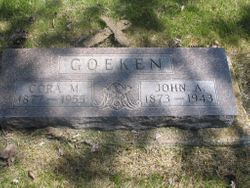
John Albert Goeken
| Birth | : | 21 Nov 1873 Atlantic, Cass County, Iowa, USA |
| Death | : | 5 Dec 1943 Spink County, South Dakota, USA |
| Burial | : | Greenlawn Cemetery, Afton, Union County, USA |
| Coordinate | : | 41.0335999, -94.1856003 |
| Plot | : | Division B, Block 035, Grave 005 |
| Description | : | Buried at Greenlawn Cemetery on December 5, 1943. |
frequently asked questions (FAQ):
-
Where is John Albert Goeken's memorial?
John Albert Goeken's memorial is located at: Greenlawn Cemetery, Afton, Union County, USA.
-
When did John Albert Goeken death?
John Albert Goeken death on 5 Dec 1943 in Spink County, South Dakota, USA
-
Where are the coordinates of the John Albert Goeken's memorial?
Latitude: 41.0335999
Longitude: -94.1856003
Family Members:
Parent
Spouse
Siblings

Children

Flowers:


Nearby Cemetories:
1. Greenlawn Cemetery
Afton, Union County, USA
Coordinate: 41.0335999, -94.1856003
2. Civil War Era Cemetery
Afton, Union County, USA
Coordinate: 41.0460854, -94.2025299
3. Saint Edwards Catholic Cemetery
Afton, Union County, USA
Coordinate: 41.0359993, -94.2129974
4. Norris Plot Cemetery
Afton, Union County, USA
Coordinate: 41.0079994, -94.1579971
5. Rollins Plot Cemetery
Afton, Union County, USA
Coordinate: 41.0040283, -94.2234802
6. County Home Cemetery
Creston, Union County, USA
Coordinate: 41.0449982, -94.2590027
7. Abel Cemetery
Arispe, Union County, USA
Coordinate: 40.9790001, -94.1429977
8. Mount Pisgah Cemetery
Thayer, Union County, USA
Coordinate: 41.0511017, -94.1007996
9. Browns Mountain Cemetery
Thayer, Union County, USA
Coordinate: 41.0499992, -94.0999985
10. Otterbein Cemetery
Thayer, Union County, USA
Coordinate: 40.9990005, -94.0879974
11. Beulah Cemetery
Thayer, Union County, USA
Coordinate: 41.0589981, -94.0759964
12. West Union Cemetery
Thayer, Union County, USA
Coordinate: 41.0191994, -94.0721970
13. Groesbeck Cemetery
Lorimor, Union County, USA
Coordinate: 41.1100006, -94.1230011
14. Cedar Grove Cemetery
Lorimor, Union County, USA
Coordinate: 41.1209984, -94.2200012
15. Bethel Cemetery
Thayer, Union County, USA
Coordinate: 41.0600014, -94.0693970
16. Dodge Center Cemetery
Afton, Union County, USA
Coordinate: 41.1279984, -94.1829987
17. Monette Cemetery
Lorimor, Union County, USA
Coordinate: 41.0800743, -94.0715866
18. Bragg Cemetery
Lorimor, Union County, USA
Coordinate: 41.1282997, -94.1433029
19. Evergreen Cemetery
Creston, Union County, USA
Coordinate: 41.1139984, -94.2839966
20. Thayer Catholic Cemetery
Thayer, Union County, USA
Coordinate: 41.0374985, -94.0357971
21. Claypool Cemetery
Thayer, Union County, USA
Coordinate: 41.0126114, -94.0303497
22. Old Jerusalem Cemetery
Creston, Union County, USA
Coordinate: 41.1159401, -94.3084335
23. Graceland Cemetery
Creston, Union County, USA
Coordinate: 41.0369987, -94.3519974
24. Lorimor Cemetery
Lorimor, Union County, USA
Coordinate: 41.1128006, -94.0516968