
| Birth | : | 20 Sep 1897 Randolph, Cedar County, Nebraska, USA |
| Death | : | 28 Apr 1991 Miller, Hand County, South Dakota, USA |
| Burial | : | G A R Cemetery, Miller, Hand County, USA |
| Coordinate | : | 44.5078011, -98.9858017 |
| Plot | : | Blk 35 Lot 13 Grave 1 |
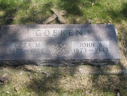
| Description | : | Lois Goeken, daughter of John & Cora (Clark) Goeken, was born Sept. 1898 in Nebraska. *1900 Nebraska Cedar Census* She married Walter C. Benning in 1917. They took over the family farm, south of Rockham, SD, but in Hand County, after Walter's father, Frank, died in 1918. They were the parents of Quentin, Marvin, Roger, Marilyn, & Walter "Gene" Benning. Walter died in 1933. Lois married Louis Eaton in 1943. She was Hand County Register of Deeds. *1945 Census* |
frequently asked questions (FAQ):
-
Where is Lois Ethel Goeken Benning Eaton's memorial?
Lois Ethel Goeken Benning Eaton's memorial is located at: G A R Cemetery, Miller, Hand County, USA.
-
When did Lois Ethel Goeken Benning Eaton death?
Lois Ethel Goeken Benning Eaton death on 28 Apr 1991 in Miller, Hand County, South Dakota, USA
-
Where are the coordinates of the Lois Ethel Goeken Benning Eaton's memorial?
Latitude: 44.5078011
Longitude: -98.9858017
Family Members:
Parent

Spouse

Siblings

Children
Flowers:


Nearby Cemetories:
1. G A R Cemetery
Miller, Hand County, USA
Coordinate: 44.5078011, -98.9858017
2. Hillcrest Cemetery
Miller, Hand County, USA
Coordinate: 44.5207000, -99.0006100
3. Saint Ann's Cemetery
Miller, Hand County, USA
Coordinate: 44.5222015, -98.9732971
4. Saint Lawrence Cemetery
Saint Lawrence, Hand County, USA
Coordinate: 44.5292015, -98.9321976
5. Morningside Cemetery
Ree Heights, Hand County, USA
Coordinate: 44.5147018, -99.1903000
6. Beulah Cemetery
Vayland, Hand County, USA
Coordinate: 44.6060982, -98.8060989
7. Alden Cemetery
Hand County, USA
Coordinate: 44.6775017, -99.1203003
8. Sunbeam Cemetery
Hand County, USA
Coordinate: 44.6777992, -98.8407974
9. Wessington Cemetery
Hand County, USA
Coordinate: 44.4569016, -98.7102966
10. Saint Josephs Catholic Cemetery
Hand County, USA
Coordinate: 44.4574400, -98.7100400
11. Burdette Cemetery
Burdette, Hand County, USA
Coordinate: 44.7002983, -98.7869034
12. McCord Cemetery
Wessington, Beadle County, USA
Coordinate: 44.3998500, -98.6673100
13. Rosehill Cemetery
Hand County, USA
Coordinate: 44.2980995, -98.7731018
14. Howell Cemetery
Miller, Hand County, USA
Coordinate: 44.7757988, -98.9766998
15. Buffalo Cemetery
Spink County, USA
Coordinate: 44.6918983, -98.6853027
16. Cedar Cemetery
Hand County, USA
Coordinate: 44.2775002, -99.2238998
17. Mount Calvary Cemetery
Polo, Hand County, USA
Coordinate: 44.7827988, -99.1097031
18. Sand Creek Cemetery
Beadle County, USA
Coordinate: 44.3055800, -98.6791200
19. Ebenezer Baptist Cemetery
Hand County, USA
Coordinate: 44.2106018, -98.9056015
20. Mondamin Cemetery
Hand County, USA
Coordinate: 44.2158012, -99.1238022
21. Highmore Cemetery
Highmore, Hyde County, USA
Coordinate: 44.5074997, -99.4197006
22. Saint Marys Catholic Cemetery
Highmore, Hyde County, USA
Coordinate: 44.5063800, -99.4214900
23. Saint Johns Cemetery
Tulare, Spink County, USA
Coordinate: 44.7202988, -98.6600037
24. New Zion Cemetery
Hand County, USA
Coordinate: 44.2043991, -98.8206024