


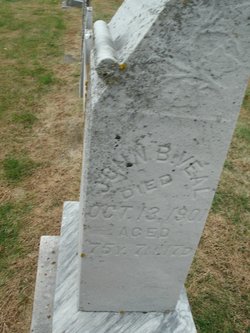
John B. Veal
| Birth | : | 26 Feb 1825 |
| Death | : | 13 Oct 1901 |
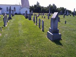
| Burial | : | West Park Cemetery, Hereford, Deaf Smith County, USA |
| Coordinate | : | 34.8210983, -102.4206009 |
| Plot | : | Row 5 Center Section |
| Description | : | Married Catherine Osborne on April 7, 1847 |
frequently asked questions (FAQ):
-
Where is John B. Veal's memorial?
John B. Veal's memorial is located at: West Park Cemetery, Hereford, Deaf Smith County, USA.
-
When did John B. Veal death?
John B. Veal death on 13 Oct 1901 in
-
Where are the coordinates of the John B. Veal's memorial?
Latitude: 34.8210983
Longitude: -102.4206009
Family Members:
Parent

Spouse

Siblings


Children
Flowers:


Nearby Cemetories:
1. West Park Cemetery
Hereford, Deaf Smith County, USA
Coordinate: 34.8210983, -102.4206009
2. Saint Thomas Episcopal Church Columbarium
Hereford, Deaf Smith County, USA
Coordinate: 34.8217660, -102.4133190
3. Saint Anthonys Cemetery
Hereford, Deaf Smith County, USA
Coordinate: 34.8327600, -102.4100700
4. Rest Lawn Cemetery
Hereford, Deaf Smith County, USA
Coordinate: 34.8643990, -102.4049988
5. Hereford Italian POW Camp Chapel Grounds
Hereford, Deaf Smith County, USA
Coordinate: 34.7458000, -102.4250000
6. Old La Plata Cemetery
Hereford, Deaf Smith County, USA
Coordinate: 34.9695880, -102.5980060
7. Westlawn Memorial Park
Dimmitt, Castro County, USA
Coordinate: 34.5380250, -102.3618610
8. Castro Memorial Gardens
Dimmitt, Castro County, USA
Coordinate: 34.5280991, -102.3197021
9. Palo Duro Wildorado
Deaf Smith County, USA
Coordinate: 35.1167700, -102.2047260
10. Holy Family Cemetery
Nazareth, Castro County, USA
Coordinate: 34.5469017, -102.1025009
11. Flagg Cemetery
Castro County, USA
Coordinate: 34.4393997, -102.3681030
12. Hart Cemetery
Hart, Castro County, USA
Coordinate: 34.3926010, -102.1346970
13. Hollene Cemetery
Hollene, Curry County, USA
Coordinate: 34.7774950, -103.0994210
14. Mitchell Cemetery
Bellview, Curry County, USA
Coordinate: 34.9150009, -103.0991974
15. Bailey County Cemetery
Muleshoe, Bailey County, USA
Coordinate: 34.2859600, -102.7661950
16. Pleasant Hill Cemetery
Pleasant Hill, Curry County, USA
Coordinate: 34.5349998, -103.0733032
17. Allen Cemetery
Quay County, USA
Coordinate: 35.0120020, -103.1381030
18. Muleshoe Memorial Park Cemetery
Muleshoe, Bailey County, USA
Coordinate: 34.2634100, -102.7851800
19. Endee Cemetery
Quay County, USA
Coordinate: 35.1453018, -103.1247025
20. Texico Cemetery
Texico, Curry County, USA
Coordinate: 34.3758011, -103.0849991
21. Boot Hill Cemetery
Quay County, USA
Coordinate: 35.0419006, -103.2397003
22. West Camp Cemetery
Bailey County, USA
Coordinate: 34.2811012, -102.9757996
23. Wayside Cemetery
Wayside, Armstrong County, USA
Coordinate: 34.7919998, -101.5466003
24. Running Water Cemetery
Edmonson, Hale County, USA
Coordinate: 34.2602710, -101.8685960