

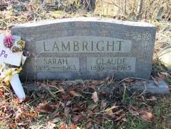
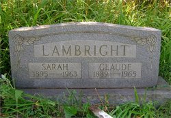
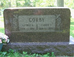
John Claude Lambright
| Birth | : | 23 Aug 1889 Industry, Beaver County, Pennsylvania, USA |
| Death | : | 30 Oct 1965 Salem, Columbiana County, Ohio, USA |
| Burial | : | Queen Family Cemetery, Copley, Lewis County, USA |
| Coordinate | : | 38.9499000, -80.6130000 |
| Description | : | Columbiana County Ohio Cemetery Inscriptions By The Columbiana County Chapter Ohio Genealogical Society Vol 13 Pg 1148 |
frequently asked questions (FAQ):
-
Where is John Claude Lambright's memorial?
John Claude Lambright's memorial is located at: Queen Family Cemetery, Copley, Lewis County, USA.
-
When did John Claude Lambright death?
John Claude Lambright death on 30 Oct 1965 in Salem, Columbiana County, Ohio, USA
-
Where are the coordinates of the John Claude Lambright's memorial?
Latitude: 38.9499000
Longitude: -80.6130000
Family Members:
Parent

Spouse
Siblings


Children
Flowers:


Nearby Cemetories:
1. Queen Family Cemetery
Copley, Lewis County, USA
Coordinate: 38.9499000, -80.6130000
2. Montgomery Cemetery
Bealls Mills, Lewis County, USA
Coordinate: 38.9648890, -80.6035400
3. Finster Chapel Cemetery
Peterson, Lewis County, USA
Coordinate: 38.9300003, -80.5999985
4. Pumphrey Cemetery
Orlando, Lewis County, USA
Coordinate: 38.9275880, -80.6216500
5. Mick Cemetery
Gilmer County, USA
Coordinate: 38.9157200, -80.6316400
6. Saint Bernard Church Cemetery
Weston, Lewis County, USA
Coordinate: 38.9928000, -80.5926940
7. Boilon Cemetery
Gilmer County, USA
Coordinate: 38.9519005, -80.6718979
8. Saint Bridget's Church Cemetery
Weston, Lewis County, USA
Coordinate: 38.9319400, -80.5572970
9. Heater Cemetery
Burnsville, Braxton County, USA
Coordinate: 38.9024560, -80.6100370
10. Blackburn Cemetery
Blackburn, Gilmer County, USA
Coordinate: 38.9235700, -80.6743200
11. Tumbling Cemetery
Gilmer County, USA
Coordinate: 38.9085999, -80.6594009
12. Tomblin Cemetery
Blackburn, Gilmer County, USA
Coordinate: 38.9076650, -80.6597330
13. Old Field Fork Cemetery
Lewis County, USA
Coordinate: 38.9827995, -80.6710968
14. Schoonover-Dawson Cemetery
Donlan, Gilmer County, USA
Coordinate: 38.9461770, -80.6854790
15. Rogers Cemetery
Gilmer County, USA
Coordinate: 38.9406013, -80.6936035
16. Oak Grove Cemetery
Lewis County, USA
Coordinate: 38.9641390, -80.5326100
17. Swecker Cemetery
Roanoke, Lewis County, USA
Coordinate: 38.9428950, -80.5282380
18. Keith Cemetery
Gilmer County, USA
Coordinate: 38.9561005, -80.6986008
19. Bailey Cemetery
Weston, Lewis County, USA
Coordinate: 38.9759270, -80.5286020
20. Canfield Cemetery
Gilmer, Gilmer County, USA
Coordinate: 38.9071999, -80.6900024
21. Harrison Grove Cemetery
Lewis County, USA
Coordinate: 39.0107994, -80.5586014
22. Locust Knob Cemetery
Stouts Mills, Gilmer County, USA
Coordinate: 38.8990000, -80.6880000
23. Dyer Cemetery
Gilmer County, USA
Coordinate: 38.9319000, -80.7110977
24. Barrett Cemetery
Burnsville, Braxton County, USA
Coordinate: 38.8778000, -80.6528015