John DeVore
| Birth | : | 1816 Harrison County, Ohio, USA |
| Death | : | 1 Nov 1871 Mills County, Iowa, USA |
| Burial | : | Dayton National Cemetery, Dayton, Montgomery County, USA |
| Coordinate | : | 39.7482224, -84.2591705 |
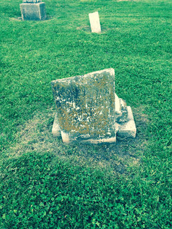
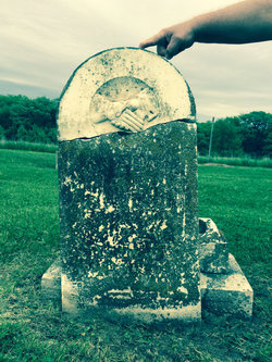
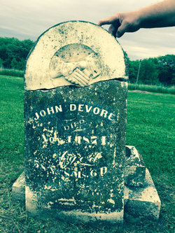
| Description | : | 9 January 2014 Hello Linda, Have you noticed the memorial for John Devore buried in Cotton Cemetery? The info. was taken from the WPA Iowa site(it's great but has mistakes too) which lists him as dying on Nov. 1,1874 but as far as the photo of his stone, it looks more like Nov. 1, 1871 to me. His "wife" Mary is just M.D. and much younger than him. I couldn't find her on the W.P. A. site. Since I'm related to both the Devores and Gonsers, John(in Cotton) may be Catherine Devore Gonser's brother- or not. I was in Mills Co. in... Read More |
frequently asked questions (FAQ):
-
Where is John DeVore's memorial?
John DeVore's memorial is located at: Dayton National Cemetery, Dayton, Montgomery County, USA.
-
When did John DeVore death?
John DeVore death on 1 Nov 1871 in Mills County, Iowa, USA
-
Where are the coordinates of the John DeVore's memorial?
Latitude: 39.7482224
Longitude: -84.2591705
Family Members:
Parent
Spouse
Siblings
Children
Flowers:
Nearby Cemetories:
1. Dayton National Cemetery
Dayton, Montgomery County, USA
Coordinate: 39.7482224, -84.2591705
2. Kinsey-Wolf Family Cemetery
Dayton, Montgomery County, USA
Coordinate: 39.7405220, -84.2540900
3. County Infirmary Cemetery
Drexel, Montgomery County, USA
Coordinate: 39.7383900, -84.2827200
4. Westmont Cemetery
Dayton, Montgomery County, USA
Coordinate: 39.7247009, -84.2453003
5. New Greencastle Cemetery
Dayton, Montgomery County, USA
Coordinate: 39.7346992, -84.2272034
6. Turner Cemetery
Montgomery County, USA
Coordinate: 39.7658005, -84.2956009
7. Old Greencastle Cemetery
Dayton, Montgomery County, USA
Coordinate: 39.7370000, -84.2143900
8. Bear Creek-Hillgrove Cemetery
Dayton, Montgomery County, USA
Coordinate: 39.7494011, -84.3071976
9. Lower Miami Cemetery
Dayton, Montgomery County, USA
Coordinate: 39.7121124, -84.2772903
10. Kaylor Family Cemetery
Frytown, Montgomery County, USA
Coordinate: 39.7086110, -84.2616670
11. Fort McKinley Cemetery
Dayton, Montgomery County, USA
Coordinate: 39.7976570, -84.2547302
12. Dayton Presbyterian and Methodist Graveyard (Defun
Dayton, Montgomery County, USA
Coordinate: 39.7558670, -84.1933820
13. Jefferson View Cemetery
Dayton, Montgomery County, USA
Coordinate: 39.7141304, -84.3090515
14. Rohrer Cemetery
Jefferson Township, Montgomery County, USA
Coordinate: 39.7094170, -84.3041940
15. Christ Episcopal Church Columbarium
Dayton, Montgomery County, USA
Coordinate: 39.7620240, -84.1937090
16. Calvary Cemetery
Dayton, Montgomery County, USA
Coordinate: 39.7248993, -84.1979980
17. Saint Henrys Cemetery
Dayton, Montgomery County, USA
Coordinate: 39.7450150, -84.1887630
18. Beth Abraham Cemetery
Oakwood, Montgomery County, USA
Coordinate: 39.7291985, -84.1919022
19. Iams Cemetery
Trotwood, Montgomery County, USA
Coordinate: 39.7864820, -84.3113620
20. Riverview Cemetery
Dayton, Montgomery County, USA
Coordinate: 39.7299995, -84.1908035
21. Liberty United Methodist Church Cemetery
Liberty, Montgomery County, USA
Coordinate: 39.7183330, -84.3243000
22. Woodland Cemetery and Arboretum
Dayton, Montgomery County, USA
Coordinate: 39.7428840, -84.1773210
23. Salem Heights Cemetery
Trotwood, Montgomery County, USA
Coordinate: 39.8125700, -84.2732500
24. Nicholas Cemetery
Montgomery County, USA
Coordinate: 39.7092018, -84.3283005

