
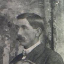
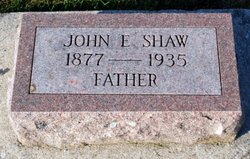
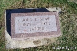

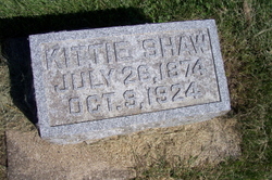
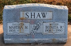
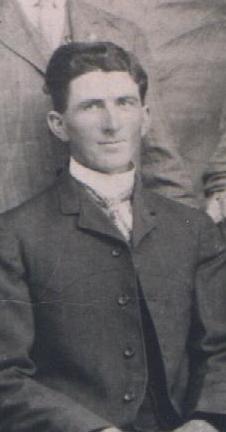
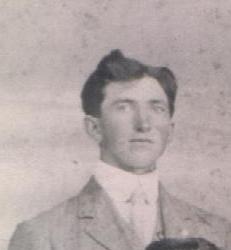
John E Shaw
| Birth | : | 1877 Clarksville, Butler County, Iowa, USA |
| Death | : | 1935 |
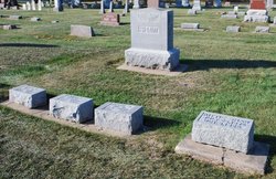
| Burial | : | Zion Lutheran Church Cemetery, Driscoll, Burleigh County, USA |
| Coordinate | : | 46.9961900, -100.1700600 |
frequently asked questions (FAQ):
-
Where is John E Shaw's memorial?
John E Shaw's memorial is located at: Zion Lutheran Church Cemetery, Driscoll, Burleigh County, USA.
-
When did John E Shaw death?
John E Shaw death on 1935 in
-
Where are the coordinates of the John E Shaw's memorial?
Latitude: 46.9961900
Longitude: -100.1700600
Family Members:
Parent
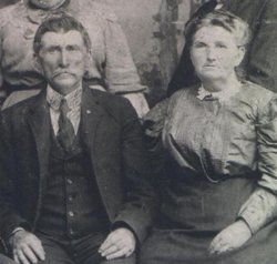

Spouse

Siblings
Children


Flowers:


Nearby Cemetories:
1. Zion Lutheran Church Cemetery
Driscoll, Burleigh County, USA
Coordinate: 46.9961900, -100.1700600
2. Mennonite Zion Cemetery
Arena, Burleigh County, USA
Coordinate: 47.0794400, -100.1572400
3. Ahola Cemetery
Wing, Burleigh County, USA
Coordinate: 47.0250626, -100.2952423
4. Chaska Gravesite
Driscoll, Burleigh County, USA
Coordinate: 46.9015700, -100.1330700
5. Chestina Cemetery
Kidder County, USA
Coordinate: 47.0539330, -100.0408600
6. Zion Langedahl Cemetery
Kidder County, USA
Coordinate: 47.0825005, -100.0714035
7. Evangelical Immanuel Cemetery
Tuttle, Kidder County, USA
Coordinate: 47.0963000, -100.0950000
8. Skudesness Lutheran Cemetery
Kidder County, USA
Coordinate: 47.0466995, -100.0072021
9. Saint Johns Cemetery
Arena, Burleigh County, USA
Coordinate: 47.1343994, -100.1564026
10. Grace Lutheran Cemetery
Driscoll, Burleigh County, USA
Coordinate: 46.8367000, -100.1409070
11. Wing Cemetery
Wing, Burleigh County, USA
Coordinate: 47.1380000, -100.2830000
12. Driscoll Cemetery
Burleigh County, USA
Coordinate: 46.8356018, -100.1397018
13. Union Cemetery
Burleigh County, USA
Coordinate: 47.0544014, -100.4203033
14. Rose Hill Cemetery
Burleigh County, USA
Coordinate: 46.9813995, -100.4338989
15. Tuttle Cemetery
Tuttle, Kidder County, USA
Coordinate: 47.1397018, -100.0077972
16. Phoenix Township Cemetery
Arena, Burleigh County, USA
Coordinate: 47.1854000, -100.1996000
17. Sterling Union Cemetery
Sterling, Burleigh County, USA
Coordinate: 46.8218994, -100.2891998
18. Holy Cross Cemetery
Tuttle, Kidder County, USA
Coordinate: 47.1408005, -99.9464035
19. Richmond Cemetery
Wing, Burleigh County, USA
Coordinate: 47.1922020, -100.2832570
20. Woodlawn Cemetery
Steele, Kidder County, USA
Coordinate: 46.8806000, -99.9094009
21. Allen Cemetery
Kidder County, USA
Coordinate: 46.9155998, -99.8647003
22. Holy Cross Cemetery
Steele, Kidder County, USA
Coordinate: 46.8463400, -99.9115500
23. Pleasant View Cemetery
McKenzie, Burleigh County, USA
Coordinate: 46.8251000, -100.4054000
24. Kleve Cemetery
Robinson, Kidder County, USA
Coordinate: 47.1112800, -99.8404200