
| Memorials | : | 1 |
| Location | : | Wing, Burleigh County, USA |
| Coordinate | : | 47.1922020, -100.2832570 |
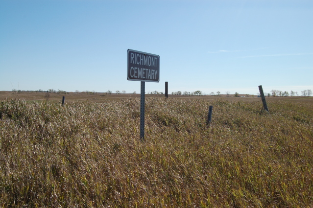
| Description | : | An abandoned cemetery in Richmond Township, just to the east side of Highway 14. It is marked with a sign (which is mis-spelled as Richmont) and a barbed wire fence that has fallen apart. The only evidence of any graves is two wooden markers that have no names or markings. |
frequently asked questions (FAQ):
-
Where is Richmond Cemetery?
Richmond Cemetery is located at Wing, Burleigh County ,North Dakota ,USA.
-
Richmond Cemetery cemetery's updated grave count on graveviews.com?
1 memorials
-
Where are the coordinates of the Richmond Cemetery?
Latitude: 47.1922020
Longitude: -100.2832570


Nearby Cemetories:
1. Wing Cemetery
Wing, Burleigh County, USA
Coordinate: 47.1380000, -100.2830000
2. Phoenix Township Cemetery
Arena, Burleigh County, USA
Coordinate: 47.1854000, -100.1996000
3. Saint Johns Cemetery
Arena, Burleigh County, USA
Coordinate: 47.1343994, -100.1564026
4. Jewish Cemetery
Regan, Burleigh County, USA
Coordinate: 47.1790200, -100.4751700
5. Mennonite Zion Cemetery
Arena, Burleigh County, USA
Coordinate: 47.0794400, -100.1572400
6. Stark Mennonite Church Cemetery
Wing, Burleigh County, USA
Coordinate: 47.3153800, -100.1770700
7. Hazel Grove Cemetery
Wing, Burleigh County, USA
Coordinate: 47.3150940, -100.1690700
8. Evangelical Immanuel Cemetery
Tuttle, Kidder County, USA
Coordinate: 47.0963000, -100.0950000
9. Regan Cemetery
Regan, Burleigh County, USA
Coordinate: 47.1605644, -100.5173187
10. Union Cemetery
Burleigh County, USA
Coordinate: 47.0544014, -100.4203033
11. Ahola Cemetery
Wing, Burleigh County, USA
Coordinate: 47.0250626, -100.2952423
12. Johns Lake Mennonite Brethren
Burleigh County, USA
Coordinate: 47.3155289, -100.4751129
13. Zion Langedahl Cemetery
Kidder County, USA
Coordinate: 47.0825005, -100.0714035
14. Tuttle Cemetery
Tuttle, Kidder County, USA
Coordinate: 47.1397018, -100.0077972
15. Zion Lutheran Church Cemetery
Driscoll, Burleigh County, USA
Coordinate: 46.9961900, -100.1700600
16. Last Rest Cemetery
McClusky, Sheridan County, USA
Coordinate: 47.3417900, -100.5028400
17. Chestina Cemetery
Kidder County, USA
Coordinate: 47.0539330, -100.0408600
18. Ghylin Union Cemetery
Burleigh County, USA
Coordinate: 47.1124992, -100.5808029
19. Denhoff Adventist Cemetery
Sheridan County, USA
Coordinate: 47.4197006, -100.2446976
20. Rose Hill Cemetery
Burleigh County, USA
Coordinate: 46.9813995, -100.4338989
21. Holy Cross Cemetery
Tuttle, Kidder County, USA
Coordinate: 47.1408005, -99.9464035
22. Skudesness Lutheran Cemetery
Kidder County, USA
Coordinate: 47.0466995, -100.0072021
23. First German Baptist Church Cemetery
McClusky, Sheridan County, USA
Coordinate: 47.4450684, -100.3536987
24. Alta Community Church Cemetery
Wilton, Burleigh County, USA
Coordinate: 47.3093000, -100.6217000