
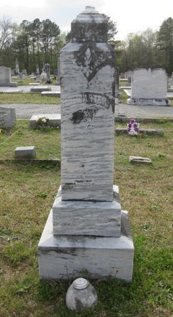
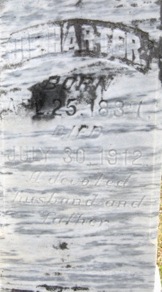
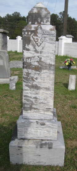
John Edmund Harter
| Birth | : | 25 Apr 1837 |
| Death | : | 30 Jul 1912 |
| Burial | : | Calvary Cemetery, Sandusky, Erie County, USA |
| Coordinate | : | 41.4383011, -82.7339020 |
| Description | : | Son of James Andrew Harter and Martha Elizabeth Street Harter. John Edmund Harter was a Civil War veteran, having lost a leg in battle. He was in the Saluda Regiment; Edgefield, South Carolina. Married to Mary Ann Burnett. He was the father of John Walter Harter, John Wesley Harter, Stephen Elias Harter, Elizabeth Cornelia Harter, Audie Burnett Harter, Mary Emma Lorena Harter, James Andrew Harter, Minnie Lee Harter, and William Henry Harter. |
frequently asked questions (FAQ):
-
Where is John Edmund Harter's memorial?
John Edmund Harter's memorial is located at: Calvary Cemetery, Sandusky, Erie County, USA.
-
When did John Edmund Harter death?
John Edmund Harter death on 30 Jul 1912 in
-
Where are the coordinates of the John Edmund Harter's memorial?
Latitude: 41.4383011
Longitude: -82.7339020
Family Members:
Parent

Spouse
Children
Flowers:


Nearby Cemetories:
1. Calvary Cemetery
Sandusky, Erie County, USA
Coordinate: 41.4383011, -82.7339020
2. Saint Marys Cemetery
Sandusky, Erie County, USA
Coordinate: 41.4425011, -82.7285995
3. Saint Joseph's Cemetery
Sandusky, Erie County, USA
Coordinate: 41.4420800, -82.7259500
4. Cholera Cemetery
Sandusky, Erie County, USA
Coordinate: 41.4496660, -82.7252970
5. First Cemetery (Defunct)
Sandusky, Erie County, USA
Coordinate: 41.4543770, -82.7216040
6. Grace Episcopal Church Columbarium
Sandusky, Erie County, USA
Coordinate: 41.4547630, -82.7093940
7. Saint Stephen United Church of Christ Columbarium
Sandusky, Erie County, USA
Coordinate: 41.4331790, -82.6861310
8. Oakland Cemetery
Sandusky, Erie County, USA
Coordinate: 41.4267807, -82.6873398
9. Venice Cemetery
Margaretta Township, Erie County, USA
Coordinate: 41.4413690, -82.7829920
10. Oheb Shalom Cemetery
Perkins Township, Erie County, USA
Coordinate: 41.4199800, -82.6902400
11. Erie County Cemetery
Sandusky, Erie County, USA
Coordinate: 41.4200580, -82.6896760
12. Ohio Veterans Home Cemetery
Sandusky, Erie County, USA
Coordinate: 41.4182940, -82.6881920
13. Wilmer Cemetery
Wilmer, Erie County, USA
Coordinate: 41.4008848, -82.7074048
14. Baum Family Cemetery
Perkins Township, Erie County, USA
Coordinate: 41.3837600, -82.7055420
15. Johnson's Island Confederate Cemetery
Marblehead, Ottawa County, USA
Coordinate: 41.5003014, -82.7300034
16. Castalia Cemetery
Castalia, Erie County, USA
Coordinate: 41.3957410, -82.8015733
17. Old Perkins Cemetery
Perkins Township, Erie County, USA
Coordinate: 41.3851460, -82.6683020
18. Perkins Cemetery
Sandusky, Erie County, USA
Coordinate: 41.3997002, -82.6505966
19. Beatty Cemetery (Defunct)
Perkins Township, Erie County, USA
Coordinate: 41.3961370, -82.6508980
20. Osborn Park Cemetery
Sandusky, Erie County, USA
Coordinate: 41.4184280, -82.6361480
21. War of 1812 Battle Site
Mineyahta-on-the Bay, Ottawa County, USA
Coordinate: 41.5140350, -82.7438530
22. Hartshorn Cemetery
Danbury, Ottawa County, USA
Coordinate: 41.5144440, -82.7499530
23. Sandhill Cemetery
Castalia, Erie County, USA
Coordinate: 41.3616982, -82.7589035
24. Wolcott Cemetery
Marblehead, Ottawa County, USA
Coordinate: 41.5177994, -82.7403030