
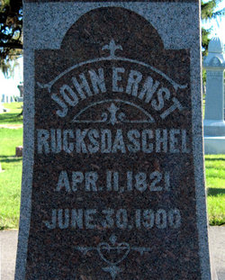
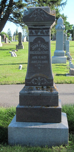


John Ernst “Ernest” Rucksdaschel
| Birth | : | 11 Apr 1821 Weissenstadt, Landkreis Wunsiedel im Fichtelgebirge, Bavaria (Bayern), Germany |
| Death | : | 30 Jun 1900 Postville, Allamakee County, Iowa, USA |
| Burial | : | Tracy Public Cemetery, Tracy, San Joaquin County, USA |
| Coordinate | : | 37.7251358, -121.4189453 |
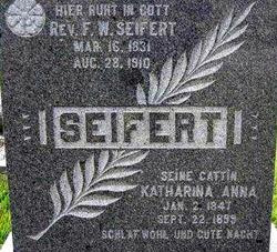
| Description | : | Ernst Ruckdaschel, one of the oldest and most respected of the German settlers in this region, was gathered to his ancestors a week ago Saturday, at the ripe age of 79 years. In reference to his life, we quote the following from the Postville "Volksblatt" (People's Paper): Ernst Ruckdaschel was born on April 11, 1821 in Weissenstadt in Bavaria at the foot of the Fichtel Mts. In his youth he learned the locksmith's trade and travelled then as a journeyman through various regions of Germany. In 1845 he married Katharine, nee Hasch. This was a happy and... Read More |
frequently asked questions (FAQ):
-
Where is John Ernst “Ernest” Rucksdaschel's memorial?
John Ernst “Ernest” Rucksdaschel's memorial is located at: Tracy Public Cemetery, Tracy, San Joaquin County, USA.
-
When did John Ernst “Ernest” Rucksdaschel death?
John Ernst “Ernest” Rucksdaschel death on 30 Jun 1900 in Postville, Allamakee County, Iowa, USA
-
Where are the coordinates of the John Ernst “Ernest” Rucksdaschel's memorial?
Latitude: 37.7251358
Longitude: -121.4189453
Family Members:
Spouse
Children

Flowers:


Nearby Cemetories:
1. Tracy Public Cemetery
Tracy, San Joaquin County, USA
Coordinate: 37.7251358, -121.4189453
2. Tracy Mausoleum
Tracy, San Joaquin County, USA
Coordinate: 37.7250214, -121.4150696
3. Valpico Memorial Park
Tracy, San Joaquin County, USA
Coordinate: 37.7113260, -121.4656510
4. Brichetto Tomb
San Joaquin County, USA
Coordinate: 37.6272011, -121.3871994
5. East Union Cemetery
Manteca, San Joaquin County, USA
Coordinate: 37.8114014, -121.2350006
6. Congregation of Ahavas Achim Cemetery
French Camp, San Joaquin County, USA
Coordinate: 37.8778419, -121.2753067
7. Chinese Cemetery
French Camp, San Joaquin County, USA
Coordinate: 37.8819962, -121.2805862
8. Congregation Adas Yeshuran of Stockton Cemetery
French Camp, San Joaquin County, USA
Coordinate: 37.8784065, -121.2740784
9. Park View Cemetery
Manteca, San Joaquin County, USA
Coordinate: 37.8617249, -121.2238312
10. Five Pillars Farm Cemetery
Livermore, Alameda County, USA
Coordinate: 37.7262764, -121.7105789
11. Ripon Cemetery
Ripon, San Joaquin County, USA
Coordinate: 37.7420311, -121.1238708
12. Atlanta Cemetery
Five Corners, San Joaquin County, USA
Coordinate: 37.8270035, -121.1420135
13. Grayson Cemetery
Grayson, Stanislaus County, USA
Coordinate: 37.5594559, -121.1802826
14. Thomas Lindsay Gravesite
San Joaquin County, USA
Coordinate: 37.9573110, -121.2918430
15. David Kelsey Gravesite
Stockton, San Joaquin County, USA
Coordinate: 37.9573110, -121.2918430
16. Citizens Cemetery
Stockton, San Joaquin County, USA
Coordinate: 37.9559410, -121.2769120
17. Union Cemetery
Brentwood, Contra Costa County, USA
Coordinate: 37.9103012, -121.6477966
18. Temple Israel Cemetery
Stockton, San Joaquin County, USA
Coordinate: 37.9640541, -121.2784348
19. Stockton State Hospital Cemetery
Stockton, San Joaquin County, USA
Coordinate: 37.9663110, -121.2846850
20. Saint Michaels Cemetery
Livermore, Alameda County, USA
Coordinate: 37.6797790, -121.7519150
21. San Joaquin Catholic Cemetery
Stockton, San Joaquin County, USA
Coordinate: 37.9707830, -121.2850190
22. IOOF Memory Gardens Cemetery
Livermore, Alameda County, USA
Coordinate: 37.6797850, -121.7526100
23. Casa Bonita Mausoleum
Stockton, San Joaquin County, USA
Coordinate: 37.9752340, -121.2877800
24. Stockton Woodland Mausoleum
Stockton, San Joaquin County, USA
Coordinate: 37.9762400, -121.2878000