
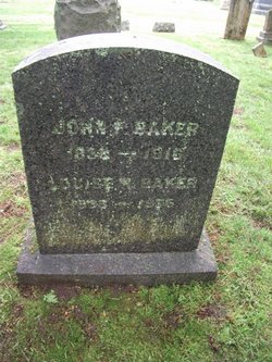
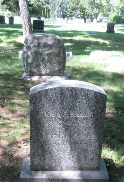
John F. Baker
| Birth | : | 10 Jul 1838 Barnstable County, Massachusetts, USA |
| Death | : | 10 Jul 1916 Osterville, Barnstable County, Massachusetts, USA |
| Burial | : | Beechwood Cemetery, Centerville, Barnstable County, USA |
| Coordinate | : | 41.6561012, -70.3491974 |
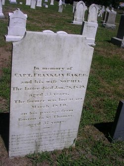
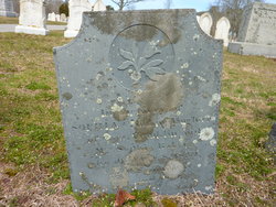
| Description | : | Son of Franklin Baker & Sophia Crosby Baker, marriage intentions on 14 May 1826 in Brewster, Massachusetts. His father was lost at sea in March 1840. His mother died 28 Jan 1839. He was raised by his father's brother Elkanah Hopkins Baker & Charity Baker. Age: 79y 7m 22d. He married Louisa Hinckley Bearse Parker on 29 Jan 1874 in Barnstable. Additional information provided by ditdit. |
frequently asked questions (FAQ):
-
Where is John F. Baker's memorial?
John F. Baker's memorial is located at: Beechwood Cemetery, Centerville, Barnstable County, USA.
-
When did John F. Baker death?
John F. Baker death on 10 Jul 1916 in Osterville, Barnstable County, Massachusetts, USA
-
Where are the coordinates of the John F. Baker's memorial?
Latitude: 41.6561012
Longitude: -70.3491974
Family Members:
Parent

Spouse
Siblings
Flowers:


Nearby Cemetories:
1. Beechwood Cemetery
Centerville, Barnstable County, USA
Coordinate: 41.6561012, -70.3491974
2. Centerville Ancient Cemetery
Centerville, Barnstable County, USA
Coordinate: 41.6547012, -70.3429031
3. Congregational Cemetery
Barnstable, Barnstable County, USA
Coordinate: 41.6459007, -70.3461990
4. Saint Francis Xavier Cemetery
Centerville, Barnstable County, USA
Coordinate: 41.6516991, -70.3331985
5. Hillside Cemetery
Osterville, Barnstable County, USA
Coordinate: 41.6316700, -70.3787100
6. Saint Peters Episcopal Church Memorial Garden
Barnstable, Barnstable County, USA
Coordinate: 41.6209700, -70.3735800
7. Saint Andrew's By The Sea Columbarium
Hyannis Port, Barnstable County, USA
Coordinate: 41.6306199, -70.3073859
8. Sandy Street Cemetery
Barnstable, Barnstable County, USA
Coordinate: 41.6968994, -70.3401031
9. South Street Cemetery
Hyannis, Barnstable County, USA
Coordinate: 41.6480300, -70.2920500
10. Marstons Mills Cemetery
Marstons Mills, Barnstable County, USA
Coordinate: 41.6612015, -70.4080963
11. Crocker Park Cemetery
Barnstable, Barnstable County, USA
Coordinate: 41.6959000, -70.3780975
12. Baptist Church Cemetery
Hyannis, Barnstable County, USA
Coordinate: 41.6519699, -70.2873230
13. Oak Grove Cemetery
Hyannis, Barnstable County, USA
Coordinate: 41.6432991, -70.2889023
14. Oak Neck Cemetery
Hyannis, Barnstable County, USA
Coordinate: 41.6431007, -70.2861023
15. Saint Patricks Cemetery
Hyannis, Barnstable County, USA
Coordinate: 41.6562996, -70.2835999
16. West Parish Burial Ground
West Barnstable, Barnstable County, USA
Coordinate: 41.6984200, -70.3842920
17. Universalist Cemetery
Hyannis, Barnstable County, USA
Coordinate: 41.6549100, -70.2822390
18. Lothrop Hill Cemetery
Barnstable, Barnstable County, USA
Coordinate: 41.7028008, -70.3174973
19. West Barnstable Cemetery
West Barnstable, Barnstable County, USA
Coordinate: 41.7080994, -70.3728027
20. Saint Marys Church Memorial Gardens
Barnstable, Barnstable County, USA
Coordinate: 41.7036000, -70.3090000
21. Cobb's Hill Cemetery East and West
Barnstable, Barnstable County, USA
Coordinate: 41.7008018, -70.2994003
22. Cummaquid Cemetery
Cummaquid, Barnstable County, USA
Coordinate: 41.6974700, -70.2804850
23. Mosswood Cemetery
Cotuit, Barnstable County, USA
Coordinate: 41.6279984, -70.4303970
24. Iyanough Gravesite
Cummaquid, Barnstable County, USA
Coordinate: 41.7014900, -70.2754100