
| Birth | : | 23 May 1925 Netawaka, Jackson County, Kansas, USA |
| Death | : | 17 Sep 1999 Lawrence, Douglas County, Kansas, USA |
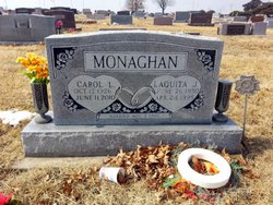
| Burial | : | Memorial Park Cemetery, Lawrence, Douglas County, USA |
| Coordinate | : | 38.9552994, -95.2153015 |
| Description | : | LAWRENCE -- John Lyle Monaghan, 74, Lawrence, died Saturday, Sept. 17, 1999, at a Lawrence hospital. He was born May 23, 1925, in Netawaka, to John W. and Dorothy Myers Monaghan. He lived in Topeka before he moved to Lawrence in 1956. He worked for the U.S. Industrial Chemical Co., and later for Koch Industries from 1957 until 1990 when he retired. He was an Army veteran of World War II. He was a member of First United Methodist Church in Lawrence where he served on several committees and was active in the Men's Group. He was a past commander of Veterans of... Read More |
frequently asked questions (FAQ):
-
Where is John Lyle Monaghan's memorial?
John Lyle Monaghan's memorial is located at: Memorial Park Cemetery, Lawrence, Douglas County, USA.
-
When did John Lyle Monaghan death?
John Lyle Monaghan death on 17 Sep 1999 in Lawrence, Douglas County, Kansas, USA
-
Where are the coordinates of the John Lyle Monaghan's memorial?
Latitude: 38.9552994
Longitude: -95.2153015
Family Members:
Parent

Siblings
Flowers:


Nearby Cemetories:
1. Memorial Park Cemetery
Lawrence, Douglas County, USA
Coordinate: 38.9552994, -95.2153015
2. Mount Calvary Catholic Cemetery
Lawrence, Douglas County, USA
Coordinate: 38.9580002, -95.2139969
3. Oak Hill Cemetery
Lawrence, Douglas County, USA
Coordinate: 38.9589005, -95.2118988
4. Trinity Episcopal Church Columbarium
Lawrence, Douglas County, USA
Coordinate: 38.9653893, -95.2373886
5. Saint Johns Catholic Cemetery
Douglas County, USA
Coordinate: 38.9437900, -95.1919600
6. Dyche Hall Natural History Museum
Lawrence, Douglas County, USA
Coordinate: 38.9584800, -95.2434800
7. Haskell Cemetery
Lawrence, Douglas County, USA
Coordinate: 38.9353790, -95.2284241
8. Franklin Cemetery
Douglas County, USA
Coordinate: 38.9437523, -95.1869431
9. Pioneer Cemetery
Lawrence, Douglas County, USA
Coordinate: 38.9528008, -95.2611008
10. First Presbyterian Church Memorial Garden
Lawrence, Douglas County, USA
Coordinate: 38.9414900, -95.2641600
11. County Poor Farm Cemetery
Douglas County, USA
Coordinate: 38.9119400, -95.2214600
12. Kennedy Cemetery
Douglas County, USA
Coordinate: 38.9112900, -95.2269200
13. Maple Grove Cemetery
Lawrence, Douglas County, USA
Coordinate: 39.0018997, -95.2316971
14. Adams Cemetery
Douglas County, USA
Coordinate: 38.9955400, -95.2509100
15. Blue Mound Cemetery
Lawrence, Douglas County, USA
Coordinate: 38.9046600, -95.1865400
16. Davis Cemetery
Lawrence, Douglas County, USA
Coordinate: 38.9722500, -95.2831100
17. Marshall Cemetery
Douglas County, USA
Coordinate: 38.9040800, -95.2446700
18. Dutton Cemetery
Douglas County, USA
Coordinate: 38.8989800, -95.2790600
19. Luckan Family Cemetery
Fall Leaf, Leavenworth County, USA
Coordinate: 38.9808500, -95.1128000
20. Corpus Christi Catholic Church Columbarium
Lawrence, Douglas County, USA
Coordinate: 38.9572250, -95.3238450
21. Cemetery Beni Israel
Eudora, Douglas County, USA
Coordinate: 38.9280128, -95.1122208
22. Lyon Family Cemetery
Lawrence, Douglas County, USA
Coordinate: 38.9877440, -95.3166530
23. Richland Cemetery
Lawrence, Douglas County, USA
Coordinate: 38.8768997, -95.2630997
24. Southwest City Cemetery
Eudora, Douglas County, USA
Coordinate: 38.9334800, -95.1070300