
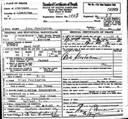
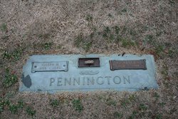
John Monroe Pennington
| Birth | : | 9 Jan 1870 |
| Death | : | 4 Apr 1930 |
| Burial | : | Riverview Cemetery, Chelan, Chelan County, USA |
| Coordinate | : | 47.8335991, -119.9944000 |
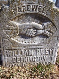
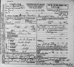
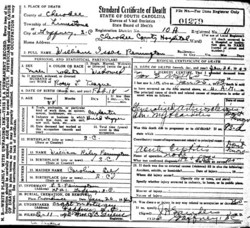
| Description | : | Parents: William Riley Pennington and Nancy Carolina Self Spouse: Mary Lucinda Self The Gaffney Ledger (Gaffney, SC) 5 Apr 1930 Sat. John Pennington to be buried Saturday Route 7 Farmer Succumbs Yesterday After Short Illness John Pennington, 60 year old farmer, died yesterday morning at his home on route 7 after an illness of only a few hours. Funeral services will be conducted at 3 o'clock Saturday afternoon at the Providence Baptist church. Interment will follow in the churchyard with the Shuford-Hatcher Company, morticians in charge. Mr. Pennington is survived by his widow, who before marriage was Miss Mary Self and three sons G. C., Emmett... Read More |
frequently asked questions (FAQ):
-
Where is John Monroe Pennington's memorial?
John Monroe Pennington's memorial is located at: Riverview Cemetery, Chelan, Chelan County, USA.
-
When did John Monroe Pennington death?
John Monroe Pennington death on 4 Apr 1930 in
-
Where are the coordinates of the John Monroe Pennington's memorial?
Latitude: 47.8335991
Longitude: -119.9944000
Family Members:
Parent
Spouse
Siblings

Children
Flowers:


Nearby Cemetories:
1. Riverview Cemetery
Chelan, Chelan County, USA
Coordinate: 47.8335991, -119.9944000
2. Mount Olivet Cemetery
Chelan, Chelan County, USA
Coordinate: 47.8451000, -119.9946000
3. Saint Andrews Episcopal Church
Chelan, Chelan County, USA
Coordinate: 47.8397460, -120.0183780
4. Chelan Fraternal Cemetery
Chelan, Chelan County, USA
Coordinate: 47.8502998, -120.0081024
5. Ballard Family Cemetery
Stayman, Chelan County, USA
Coordinate: 47.7811100, -120.1133300
6. Fletcher Cemetery
Douglas County, USA
Coordinate: 47.7430992, -119.9403000
7. Manson Indian Cemetery
Manson, Chelan County, USA
Coordinate: 47.8800000, -120.1300000
8. Brays Landing Cemetery
Douglas County, USA
Coordinate: 47.7364120, -120.1704660
9. Kummer Cemetery
Waterville, Douglas County, USA
Coordinate: 47.6559000, -120.0332000
10. Waterville Cemetery
Waterville, Douglas County, USA
Coordinate: 47.6418500, -120.0685940
11. Gate of Heaven Catholic Cemetery
Waterville, Douglas County, USA
Coordinate: 47.6382100, -120.0671690
12. Packwood Memorial Cemetery
Dyer, Douglas County, USA
Coordinate: 48.0118305, -119.8178880
13. Douglas Lutheran Cemetery
Douglas County, USA
Coordinate: 47.6189003, -119.9614029
14. Dick Family Cemetery
Okanogan County, USA
Coordinate: 48.0502700, -119.9241700
15. Miller Family Cemetery
Okanogan County, USA
Coordinate: 48.0530300, -119.9288000
16. Pateros Cemetery
Pateros, Okanogan County, USA
Coordinate: 48.0516600, -119.9097300
17. Badger Mountain View Cemetery
Douglas County, USA
Coordinate: 47.6088000, -120.0476000
18. Mansfield Cemetery
Mansfield, Douglas County, USA
Coordinate: 47.8088880, -119.6508330
19. Orondo Community Cemetery
Orondo, Douglas County, USA
Coordinate: 47.6486015, -120.2136002
20. Happy Home Cemetery
Farmer, Douglas County, USA
Coordinate: 47.6268997, -119.8125000
21. Buckingham Cemetery
Douglas County, USA
Coordinate: 47.8669014, -119.6286011
22. Entiat Cemetery
Entiat, Chelan County, USA
Coordinate: 47.6755981, -120.3043976
23. Jameson Cemetery
Douglas County, USA
Coordinate: 47.6857986, -119.6624985
24. Bridgeport Cemetery
Bridgeport, Douglas County, USA
Coordinate: 48.0050000, -119.6738800