
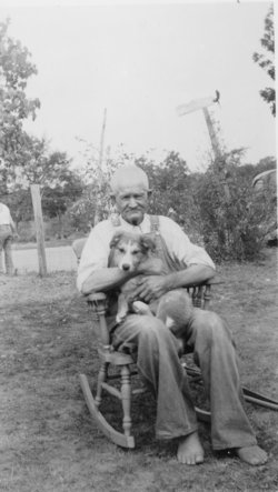
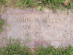
John Nesbit Wells
| Birth | : | 30 Apr 1854 Dent County, Missouri, USA |
| Death | : | 27 Jan 1941 Cantwell, St. Francois County, Missouri, USA |
| Burial | : | Longford Christ Church Pioneer Cemetery, Longford, Northern Midlands Council, Australia |
| Coordinate | : | -41.5943270, 147.1194860 |
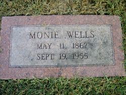
| Description | : | Mr. J. N. Wells and Miss Mary E. Forshee; married on 27 April 1876 by James Kendall, Minister of M. E. Church South at St. Francois Co., Mo. --------------------------------------- John N. Wells of Big River, St. Francois Co., Mo. over 21; Monie Hardy of Flat River, St. Francois Co., Mo. over 18; 18 April 1895 license; married on 21 April 1895 by N. O. Fleming, MG at bride's residence, St. Francois Co., Mo. --------------------------------------- John Nesbit Wells, son of the late Levi and Elsie Wells, was born in Dent County, MO., on Apr. 30, 1854, and died at his home two miles... Read More |
frequently asked questions (FAQ):
-
Where is John Nesbit Wells's memorial?
John Nesbit Wells's memorial is located at: Longford Christ Church Pioneer Cemetery, Longford, Northern Midlands Council, Australia.
-
When did John Nesbit Wells death?
John Nesbit Wells death on 27 Jan 1941 in Cantwell, St. Francois County, Missouri, USA
-
Where are the coordinates of the John Nesbit Wells's memorial?
Latitude: -41.5943270
Longitude: 147.1194860
Family Members:
Parent
Spouse
Siblings
Children
Flowers:


Nearby Cemetories:
1. Longford Christ Church Pioneer Cemetery
Longford, Northern Midlands Council, Australia
Coordinate: -41.5943270, 147.1194860
2. St Augustine Catholic Church Cemetery
Longford, Northern Midlands Council, Australia
Coordinate: -41.5932650, 147.1140900
3. Longford Uniting Church Cemetery
Longford, Northern Midlands Council, Australia
Coordinate: -41.6096150, 147.1162410
4. Longford General Cemetery
Longford, Northern Midlands Council, Australia
Coordinate: -41.6223790, 147.1055480
5. Perth General Cemetery
Perth, Northern Midlands Council, Australia
Coordinate: -41.5775800, 147.1612200
6. St. Andrew's Anglican Cemetery
Perth, Northern Midlands Council, Australia
Coordinate: -41.5727500, 147.1777170
7. Illawarra Christ Church Cemetery
Carrick, Meander Valley Council, Australia
Coordinate: -41.5502380, 147.0651810
8. St. Andrew's Uniting Church Cemetery
Evandale, Northern Midlands Council, Australia
Coordinate: -41.5713670, 147.2452090
9. Church Of The Good Shepherd
Hadspen, Meander Valley Council, Australia
Coordinate: -41.5076150, 147.0618590
10. Hadspen Uniting Church Cemetery
Hadspen, Meander Valley Council, Australia
Coordinate: -41.5064200, 147.0637300
11. Saint Andrews Anglican Cemetery
Evandale, Northern Midlands Council, Australia
Coordinate: -41.5694500, 147.2478100
12. Evandale Rose Garden
Evandale, Northern Midlands Council, Australia
Coordinate: -41.5698800, 147.2489770
13. Cressy Methodist Cemetery
Cressy, Northern Midlands Council, Australia
Coordinate: -41.6893220, 147.0779440
14. Holy Trinity Anglican Cemetery
Cressy, Northern Midlands Council, Australia
Coordinate: -41.6896474, 147.0786681
15. Holy Nativity Anglican Cemetery
Bishopsbourne, Northern Midlands Council, Australia
Coordinate: -41.6173490, 146.9869290
16. Evandale Catholic Cemetery
Evandale, Northern Midlands Council, Australia
Coordinate: -41.5685580, 147.2530820
17. Carrick Anglican Churchyard
Carrick, Meander Valley Council, Australia
Coordinate: -41.5306800, 147.0075400
18. St. James Anglican Church Cemetery
Youngtown, Launceston City, Australia
Coordinate: -41.4900170, 147.1662147
19. Prospect Vale Congregational Cemetery
Prospect Vale, Meander Valley Council, Australia
Coordinate: -41.4751150, 147.1275000
20. White Hills St Johns Anglican Church Cemetery
White Hills, Launceston City, Australia
Coordinate: -41.5177060, 147.2517580
21. Quarantine Station Cemetery
Kings Meadows, Launceston City, Australia
Coordinate: -41.4744510, 147.1743800
22. Carr Villa War Cemetery
Kings Meadows, Launceston City, Australia
Coordinate: -41.4714880, 147.1722230
23. Carr Villa Memorial Park
Kings Meadows, Launceston City, Australia
Coordinate: -41.4697360, 147.1672120
24. Launceston Garden of Remembrance
Launceston, Launceston City, Australia
Coordinate: -41.4706010, 147.1717710