
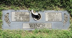
Nellie Viola Wells Winch
| Birth | : | 18 Dec 1904 Farmington, St. Francois County, Missouri, USA |
| Death | : | 16 Dec 2000 Farmington, St. Francois County, Missouri, USA |
| Burial | : | Leesville Cemetery, Leesville, Carroll County, USA |
| Coordinate | : | 40.4550018, -81.2114029 |
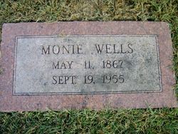
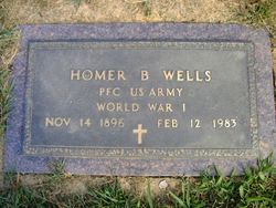
| Description | : | Nellie Viola Winch, age 95, of Bonne Terre died Dec. 16, 2000, at Mineral Area Regional Medical Center. She was born Dec. 18, 1904, in Farmington. She was a member of the Parkview Freewill Baptsist Church, and was preced in death by her parents, John and Monie Hardy Wells, and two brothers, Ollie and Homer Wells. She is survived by her husband Houston Winch. Visitation will be Monday from 3 p.m. to 7 p.m. at C.Z. Boyer and Son in Desloge. Services will be Tuesday at 11 a.m. at Boyer Chapel. Rev. Charlie Miller and lindell Richardson will officiate. Interment will be... Read More |
frequently asked questions (FAQ):
-
Where is Nellie Viola Wells Winch's memorial?
Nellie Viola Wells Winch's memorial is located at: Leesville Cemetery, Leesville, Carroll County, USA.
-
When did Nellie Viola Wells Winch death?
Nellie Viola Wells Winch death on 16 Dec 2000 in Farmington, St. Francois County, Missouri, USA
-
Where are the coordinates of the Nellie Viola Wells Winch's memorial?
Latitude: 40.4550018
Longitude: -81.2114029
Family Members:
Parent
Spouse

Siblings
Flowers:


Nearby Cemetories:
1. Leesville Cemetery
Leesville, Carroll County, USA
Coordinate: 40.4550018, -81.2114029
2. New Hagerstown Cemetery
New Hagerstown, Carroll County, USA
Coordinate: 40.4446983, -81.1893997
3. Longview Cemetery
Bowerston, Harrison County, USA
Coordinate: 40.4324989, -81.1872025
4. Tunnel Hill Cemetery
Bowerston, Harrison County, USA
Coordinate: 40.4213982, -81.2238998
5. Veteran's Grave
Orange Township, Carroll County, USA
Coordinate: 40.4931470, -81.2003677
6. Swinehart Cemetery
Carroll County, USA
Coordinate: 40.4327000, -81.1642170
7. Bethel Cemetery
Leavittsville, Carroll County, USA
Coordinate: 40.4921989, -81.1841965
8. Sherrodsville Cemetery
Sherrodsville, Carroll County, USA
Coordinate: 40.4836006, -81.2544022
9. Saint Francis Catholic Cemetery
Sherrodsville, Carroll County, USA
Coordinate: 40.4951920, -81.2349170
10. Heller Cemetery
Bowerston, Harrison County, USA
Coordinate: 40.4089012, -81.2043991
11. Roby Cemetery
Sherrodsville, Carroll County, USA
Coordinate: 40.5028000, -81.2382965
12. Sherrodsville Memorial Gardens Cemetery
Sherrodsville, Carroll County, USA
Coordinate: 40.4852982, -81.2675018
13. Mount Tabor Cemetery
Carroll County, USA
Coordinate: 40.4817009, -81.1483002
14. Price-Rollins Cemetery
Carroll County, USA
Coordinate: 40.5088997, -81.1956024
15. Mount Olive Cemetery
Carroll County, USA
Coordinate: 40.4488983, -81.1382980
16. Palermo Cemetery
Carroll County, USA
Coordinate: 40.4894444, -81.1522220
17. Leavittsville Cemetery
Leavittsville, Carroll County, USA
Coordinate: 40.5133018, -81.1967010
18. Conotton Cemetery
Harrison County, USA
Coordinate: 40.4103012, -81.1489029
19. Pleasant Valley Cemetery
Dennison, Tuscarawas County, USA
Coordinate: 40.4152800, -81.2858300
20. Zion Cemetery
Sherrodsville, Carroll County, USA
Coordinate: 40.5208015, -81.2518997
21. Boone Family Cemetery
Tuscarawas County, USA
Coordinate: 40.4112100, -81.2899700
22. Plum Run Cemetery
Bowerston, Harrison County, USA
Coordinate: 40.3819008, -81.2294006
23. Plum Run Hill Top Cemetery
Harrison County, USA
Coordinate: 40.3814011, -81.2324982
24. Roxford Church Cemetery
Tuscarawas County, USA
Coordinate: 40.4703400, -81.3087200