
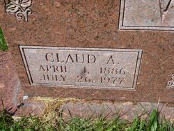

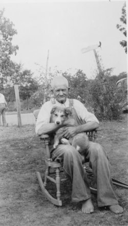
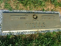
Claude A Wells
| Birth | : | 1 Apr 1886 Desloge, St. Francois County, Missouri, USA |
| Death | : | 26 Jul 1977 Farmington, St. Francois County, Missouri, USA |
| Burial | : | Leesville Cemetery, Leesville, Carroll County, USA |
| Coordinate | : | 40.4550018, -81.2114029 |
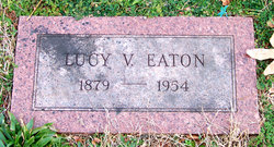
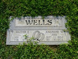
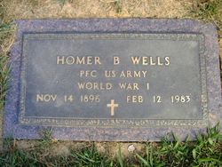
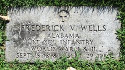
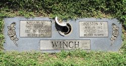
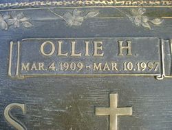
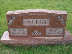
| Description | : | Claude A. Wells, 91, of Desloge was born Apr. 1, 1886 near Desloge and died July 26 at Farmington Community Hospital. He was the son of the late Nesbit and Elizabeth Forshee Wells. Surviving are his widow, Virginia Story Wells, Desloge; a son and diaghter-in-law, Vernon and Lillian Wells, Desloge; two grandchildren; five great-grandchildren; three brothers, Homer Wells, Desloge, Audrey Wells of Middelton and Ollie Wells, Rivermines; a sister Nellie (Mrs. Houston) Winch, Rt. 1, Bonne Terre. Mrs. Wells will be in state at 4 p.m. today at Boyer Funeral Home in Desloge. Chapel services are scheduled for 2 p.m. Thursday with... Read More |
frequently asked questions (FAQ):
-
Where is Claude A Wells's memorial?
Claude A Wells's memorial is located at: Leesville Cemetery, Leesville, Carroll County, USA.
-
When did Claude A Wells death?
Claude A Wells death on 26 Jul 1977 in Farmington, St. Francois County, Missouri, USA
-
Where are the coordinates of the Claude A Wells's memorial?
Latitude: 40.4550018
Longitude: -81.2114029
Family Members:
Parent
Spouse
Siblings
Children
Flowers:


Nearby Cemetories:
1. Leesville Cemetery
Leesville, Carroll County, USA
Coordinate: 40.4550018, -81.2114029
2. New Hagerstown Cemetery
New Hagerstown, Carroll County, USA
Coordinate: 40.4446983, -81.1893997
3. Longview Cemetery
Bowerston, Harrison County, USA
Coordinate: 40.4324989, -81.1872025
4. Tunnel Hill Cemetery
Bowerston, Harrison County, USA
Coordinate: 40.4213982, -81.2238998
5. Veteran's Grave
Orange Township, Carroll County, USA
Coordinate: 40.4931470, -81.2003677
6. Swinehart Cemetery
Carroll County, USA
Coordinate: 40.4327000, -81.1642170
7. Bethel Cemetery
Leavittsville, Carroll County, USA
Coordinate: 40.4921989, -81.1841965
8. Sherrodsville Cemetery
Sherrodsville, Carroll County, USA
Coordinate: 40.4836006, -81.2544022
9. Saint Francis Catholic Cemetery
Sherrodsville, Carroll County, USA
Coordinate: 40.4951920, -81.2349170
10. Heller Cemetery
Bowerston, Harrison County, USA
Coordinate: 40.4089012, -81.2043991
11. Roby Cemetery
Sherrodsville, Carroll County, USA
Coordinate: 40.5028000, -81.2382965
12. Sherrodsville Memorial Gardens Cemetery
Sherrodsville, Carroll County, USA
Coordinate: 40.4852982, -81.2675018
13. Mount Tabor Cemetery
Carroll County, USA
Coordinate: 40.4817009, -81.1483002
14. Price-Rollins Cemetery
Carroll County, USA
Coordinate: 40.5088997, -81.1956024
15. Mount Olive Cemetery
Carroll County, USA
Coordinate: 40.4488983, -81.1382980
16. Palermo Cemetery
Carroll County, USA
Coordinate: 40.4894444, -81.1522220
17. Leavittsville Cemetery
Leavittsville, Carroll County, USA
Coordinate: 40.5133018, -81.1967010
18. Conotton Cemetery
Harrison County, USA
Coordinate: 40.4103012, -81.1489029
19. Pleasant Valley Cemetery
Dennison, Tuscarawas County, USA
Coordinate: 40.4152800, -81.2858300
20. Zion Cemetery
Sherrodsville, Carroll County, USA
Coordinate: 40.5208015, -81.2518997
21. Boone Family Cemetery
Tuscarawas County, USA
Coordinate: 40.4112100, -81.2899700
22. Plum Run Cemetery
Bowerston, Harrison County, USA
Coordinate: 40.3819008, -81.2294006
23. Plum Run Hill Top Cemetery
Harrison County, USA
Coordinate: 40.3814011, -81.2324982
24. Roxford Church Cemetery
Tuscarawas County, USA
Coordinate: 40.4703400, -81.3087200