
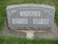
John Paul Groger
| Birth | : | 26 Apr 1906 Ellensburg, Kittitas County, Washington, USA |
| Death | : | 19 Aug 1974 Ellensburg, Kittitas County, Washington, USA |
| Burial | : | Goodrich Cemetery, Goodrich, Sheridan County, USA |
| Coordinate | : | 47.4716988, -100.1406021 |
| Description | : | OBIT: John P. Groger, 68, native Ellensburg resident, died Monday at Kittitas Valley Community Hospital. He was born April 26, 1906. He lived in the Woldale District until 1968 when he moved to Ellensburg where he since made his home at 318 1/2 N. Main. For the past three months he has resided at Haven House Nursing Home. He was a veteran of the U.S. Army, serving in World War II. He was a trapper, gardener and enjoyed rock collecting. He is survived by two sisters, Mrs. Freda Hayes of Kittitas and Mrs. Selma Getchell of Seattle; several... Read More |
frequently asked questions (FAQ):
-
Where is John Paul Groger's memorial?
John Paul Groger's memorial is located at: Goodrich Cemetery, Goodrich, Sheridan County, USA.
-
When did John Paul Groger death?
John Paul Groger death on 19 Aug 1974 in Ellensburg, Kittitas County, Washington, USA
-
Where are the coordinates of the John Paul Groger's memorial?
Latitude: 47.4716988
Longitude: -100.1406021
Family Members:
Parent

Siblings

Flowers:


Nearby Cemetories:
1. Goodrich Cemetery
Goodrich, Sheridan County, USA
Coordinate: 47.4716988, -100.1406021
2. Goodrich Seventh-Day Adventist Cemetery
Goodrich, Sheridan County, USA
Coordinate: 47.4803200, -100.1402969
3. Denhoff Catholic Cemetery
Denhoff, Sheridan County, USA
Coordinate: 47.4853247, -100.2673544
4. Denhoff Cemetery
Denhoff, Sheridan County, USA
Coordinate: 47.4839973, -100.2679291
5. Denhoff Adventist Cemetery
Sheridan County, USA
Coordinate: 47.4197006, -100.2446976
6. Saint Jacobus Lutheran Cemetery
Sheridan County, USA
Coordinate: 47.5739100, -100.1917600
7. Fairview Cemetery
Sheridan County, USA
Coordinate: 47.6032982, -100.1502991
8. First German Baptist Church Cemetery
McClusky, Sheridan County, USA
Coordinate: 47.4450684, -100.3536987
9. Pleasant Hill Cemetery
Hurdsfield, Wells County, USA
Coordinate: 47.4364014, -99.9274979
10. Hazel Grove Cemetery
Wing, Burleigh County, USA
Coordinate: 47.3150940, -100.1690700
11. Stark Mennonite Church Cemetery
Wing, Burleigh County, USA
Coordinate: 47.3153800, -100.1770700
12. Zion Cemetery
Sheridan County, USA
Coordinate: 47.6493988, -100.0755997
13. Saint Emanuel Evangelical Lutheran Cemetery
Sheridan County, USA
Coordinate: 47.6594009, -100.2247009
14. McClusky City Cemetery
McClusky, Sheridan County, USA
Coordinate: 47.4801178, -100.4373550
15. Holy Family Catholic Cemetery
McClusky, Sheridan County, USA
Coordinate: 47.4807854, -100.4375076
16. Lincoln Valley Seventh-Day Adventist Cemetery
Lincoln Valley, Sheridan County, USA
Coordinate: 47.6179466, -100.3515167
17. Lincoln Valley Baptist Cemetery
Lincoln Valley, Sheridan County, USA
Coordinate: 47.6469688, -100.2972870
18. Hope Mennonite Cemetery
Wells County, USA
Coordinate: 47.5307999, -99.8422012
19. Saint Petri Lutheran Cemetery
Harvey, Wells County, USA
Coordinate: 47.6176020, -99.9048720
20. Eigenheim Cemetery
Harvey, Wells County, USA
Coordinate: 47.6175620, -99.9046900
21. Hieb-Huft Cemetery
McClusky, Sheridan County, USA
Coordinate: 47.6029100, -100.3952700
22. Harvey Mennonite Brethren Cemetery
Harvey, Wells County, USA
Coordinate: 47.6739006, -100.0260010
23. Chaseley Cemetery
Wells County, USA
Coordinate: 47.4571991, -99.8191986
24. Lincoln Valley Lutheran Cemetery
Lincoln Valley, Sheridan County, USA
Coordinate: 47.6722527, -100.3097916