
| Memorials | : | 1 |
| Location | : | Wing, Burleigh County, USA |
| Coordinate | : | 47.3153800, -100.1770700 |
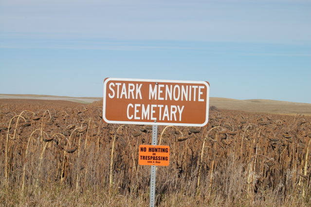
| Description | : | This cemetery was located in the SW 1/4 of Section 3 of Hazel Grove Township. At one time there was a church alongside the cemetery, but after the church disbanded in the 1920's, the building was moved to Goodrich, about 12 miles away. The cemetery had a fence around it, but at some point the fence was removed and eventually the cemetery was plowed over. Unfortunately, there is no evidence of graves or gravestones any longer. All that remains is a sign that was placed by the county. This information came from the Burleigh County Book of... Read More |
frequently asked questions (FAQ):
-
Where is Stark Mennonite Church Cemetery?
Stark Mennonite Church Cemetery is located at Wing, Burleigh County ,North Dakota ,USA.
-
Stark Mennonite Church Cemetery cemetery's updated grave count on graveviews.com?
1 memorials
-
Where are the coordinates of the Stark Mennonite Church Cemetery?
Latitude: 47.3153800
Longitude: -100.1770700
Nearby Cemetories:
1. Hazel Grove Cemetery
Wing, Burleigh County, USA
Coordinate: 47.3150940, -100.1690700
2. Denhoff Adventist Cemetery
Sheridan County, USA
Coordinate: 47.4197006, -100.2446976
3. Phoenix Township Cemetery
Arena, Burleigh County, USA
Coordinate: 47.1854000, -100.1996000
4. Richmond Cemetery
Wing, Burleigh County, USA
Coordinate: 47.1922020, -100.2832570
5. Goodrich Cemetery
Goodrich, Sheridan County, USA
Coordinate: 47.4716988, -100.1406021
6. Goodrich Seventh-Day Adventist Cemetery
Goodrich, Sheridan County, USA
Coordinate: 47.4803200, -100.1402969
7. First German Baptist Church Cemetery
McClusky, Sheridan County, USA
Coordinate: 47.4450684, -100.3536987
8. Denhoff Cemetery
Denhoff, Sheridan County, USA
Coordinate: 47.4839973, -100.2679291
9. Denhoff Catholic Cemetery
Denhoff, Sheridan County, USA
Coordinate: 47.4853247, -100.2673544
10. Saint Johns Cemetery
Arena, Burleigh County, USA
Coordinate: 47.1343994, -100.1564026
11. Wing Cemetery
Wing, Burleigh County, USA
Coordinate: 47.1380000, -100.2830000
12. Johns Lake Mennonite Brethren
Burleigh County, USA
Coordinate: 47.3155289, -100.4751129
13. Saint Petri Cemetery
Kidder County, USA
Coordinate: 47.2291985, -99.9064026
14. Pleasant Hill Cemetery
Hurdsfield, Wells County, USA
Coordinate: 47.4364014, -99.9274979
15. Tuttle Cemetery
Tuttle, Kidder County, USA
Coordinate: 47.1397018, -100.0077972
16. Last Rest Cemetery
McClusky, Sheridan County, USA
Coordinate: 47.3417900, -100.5028400
17. Evangelical Immanuel Cemetery
Tuttle, Kidder County, USA
Coordinate: 47.0963000, -100.0950000
18. Holy Cross Cemetery
Tuttle, Kidder County, USA
Coordinate: 47.1408005, -99.9464035
19. Mennonite Zion Cemetery
Arena, Burleigh County, USA
Coordinate: 47.0794400, -100.1572400
20. McClusky City Cemetery
McClusky, Sheridan County, USA
Coordinate: 47.4801178, -100.4373550
21. Holy Family Catholic Cemetery
McClusky, Sheridan County, USA
Coordinate: 47.4807854, -100.4375076
22. Zion Langedahl Cemetery
Kidder County, USA
Coordinate: 47.0825005, -100.0714035
23. Jewish Cemetery
Regan, Burleigh County, USA
Coordinate: 47.1790200, -100.4751700
24. Saint Jacobus Lutheran Cemetery
Sheridan County, USA
Coordinate: 47.5739100, -100.1917600