
| Memorials | : | 0 |
| Location | : | Wing, Burleigh County, USA |
| Coordinate | : | 47.3150940, -100.1690700 |
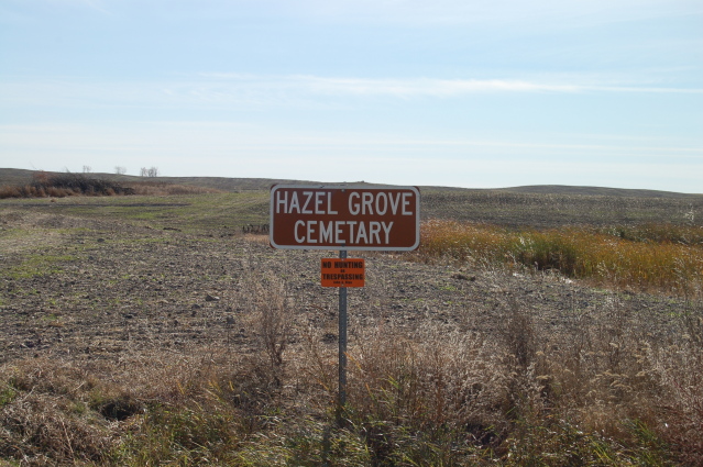
| Description | : | This cemetery was in the NE corner of the NW 1/4 of section 10 of Hazelgrove township. The cemetery has been plowed under and other than a sign, there is no evidence that a cemetery ever existed. The Burleigh County Book of Remembrances lists three individuals and five unknowns as being buried in the cemetery. |
frequently asked questions (FAQ):
-
Where is Hazel Grove Cemetery?
Hazel Grove Cemetery is located at 461st Avenue NE Wing, Burleigh County ,North Dakota , 58494USA.
-
Hazel Grove Cemetery cemetery's updated grave count on graveviews.com?
0 memorials
-
Where are the coordinates of the Hazel Grove Cemetery?
Latitude: 47.3150940
Longitude: -100.1690700
Nearby Cemetories:
1. Stark Mennonite Church Cemetery
Wing, Burleigh County, USA
Coordinate: 47.3153800, -100.1770700
2. Denhoff Adventist Cemetery
Sheridan County, USA
Coordinate: 47.4197006, -100.2446976
3. Phoenix Township Cemetery
Arena, Burleigh County, USA
Coordinate: 47.1854000, -100.1996000
4. Richmond Cemetery
Wing, Burleigh County, USA
Coordinate: 47.1922020, -100.2832570
5. Goodrich Cemetery
Goodrich, Sheridan County, USA
Coordinate: 47.4716988, -100.1406021
6. Goodrich Seventh-Day Adventist Cemetery
Goodrich, Sheridan County, USA
Coordinate: 47.4803200, -100.1402969
7. First German Baptist Church Cemetery
McClusky, Sheridan County, USA
Coordinate: 47.4450684, -100.3536987
8. Saint Johns Cemetery
Arena, Burleigh County, USA
Coordinate: 47.1343994, -100.1564026
9. Denhoff Cemetery
Denhoff, Sheridan County, USA
Coordinate: 47.4839973, -100.2679291
10. Denhoff Catholic Cemetery
Denhoff, Sheridan County, USA
Coordinate: 47.4853247, -100.2673544
11. Wing Cemetery
Wing, Burleigh County, USA
Coordinate: 47.1380000, -100.2830000
12. Saint Petri Cemetery
Kidder County, USA
Coordinate: 47.2291985, -99.9064026
13. Pleasant Hill Cemetery
Hurdsfield, Wells County, USA
Coordinate: 47.4364014, -99.9274979
14. Tuttle Cemetery
Tuttle, Kidder County, USA
Coordinate: 47.1397018, -100.0077972
15. Johns Lake Mennonite Brethren
Burleigh County, USA
Coordinate: 47.3155289, -100.4751129
16. Evangelical Immanuel Cemetery
Tuttle, Kidder County, USA
Coordinate: 47.0963000, -100.0950000
17. Last Rest Cemetery
McClusky, Sheridan County, USA
Coordinate: 47.3417900, -100.5028400
18. Holy Cross Cemetery
Tuttle, Kidder County, USA
Coordinate: 47.1408005, -99.9464035
19. Mennonite Zion Cemetery
Arena, Burleigh County, USA
Coordinate: 47.0794400, -100.1572400
20. Zion Langedahl Cemetery
Kidder County, USA
Coordinate: 47.0825005, -100.0714035
21. McClusky City Cemetery
McClusky, Sheridan County, USA
Coordinate: 47.4801178, -100.4373550
22. Holy Family Catholic Cemetery
McClusky, Sheridan County, USA
Coordinate: 47.4807854, -100.4375076
23. Jewish Cemetery
Regan, Burleigh County, USA
Coordinate: 47.1790200, -100.4751700
24. Saint Jacobus Lutheran Cemetery
Sheridan County, USA
Coordinate: 47.5739100, -100.1917600