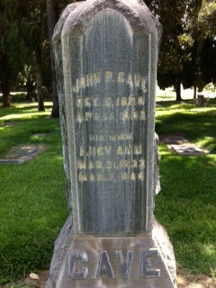
John Pemberton Cave
| Birth | : | 5 Oct 1820 Kentucky, USA |
| Death | : | 14 Apr 1902 San Bernardino County, California, USA |
| Burial | : | Saint Peter Greenfield Cemetery, Vermillion, Clay County, USA |
| Coordinate | : | 42.8608017, -96.8644028 |
| Plot | : | Orig-314 |
| Description | : | John is the son of Pemberton Cave and Anna Pemberton. John married Lucy Ann Barnett, 21 Dec 1841, in Green Co., Kentucky. John was found in the 1880 Census of San Bernardino, San Bernardino, California with his wife and 2 sons. John was found in the 1900 Census of Corona, Riverside, California with his daughter and son-in-law Alfaretta and Charles Wall and their children. |
frequently asked questions (FAQ):
-
Where is John Pemberton Cave's memorial?
John Pemberton Cave's memorial is located at: Saint Peter Greenfield Cemetery, Vermillion, Clay County, USA.
-
When did John Pemberton Cave death?
John Pemberton Cave death on 14 Apr 1902 in San Bernardino County, California, USA
-
Where are the coordinates of the John Pemberton Cave's memorial?
Latitude: 42.8608017
Longitude: -96.8644028
Family Members:
Parent
Spouse
Siblings
Children
Flowers:
Nearby Cemetories:
1. Saint Peter Greenfield Cemetery
Vermillion, Clay County, USA
Coordinate: 42.8608017, -96.8644028
2. Clay Point Cemetery
Prairie Center Township, Clay County, USA
Coordinate: 42.8987700, -96.9065600
3. Saint Mary Cemetery
Union County, USA
Coordinate: 42.8520584, -96.7877502
4. Spirit Mound Cemetery
Clay County, USA
Coordinate: 42.8885994, -96.9424973
5. Saint Agnes Cemetery
Vermillion, Clay County, USA
Coordinate: 42.7872009, -96.8499985
6. Rockfield Cemetery
Clay County, USA
Coordinate: 42.9397011, -96.8302994
7. Clay Creek Cemetery
Clay County, USA
Coordinate: 42.8516998, -96.9788971
8. Ahlsborg Lutheran Cemetery
Union County, USA
Coordinate: 42.8228000, -96.7612000
9. Dalesburg Lutheran Cemetery
Vermillion, Clay County, USA
Coordinate: 42.9389424, -96.9242594
10. Dowlin Cemetery
Burbank, Clay County, USA
Coordinate: 42.7789001, -96.8107986
11. Bluff View Cemetery
Vermillion, Clay County, USA
Coordinate: 42.7714000, -96.9056000
12. Saint Agnes Calvary Cemetery
Vermillion, Clay County, USA
Coordinate: 42.7715900, -96.9072100
13. Brule Creek Cemetery
Spink Township, Union County, USA
Coordinate: 42.8346510, -96.7324350
14. Pleasant Hill Cemetery Old
Spink, Union County, USA
Coordinate: 42.8588462, -96.7215592
15. Olbue Lerseth Cemetery
Beresford, Union County, USA
Coordinate: 42.9281100, -96.7516100
16. Roseni Lutheran Church Cemetery
Beresford, Union County, USA
Coordinate: 42.9388000, -96.7639000
17. Dalesburg Baptist Cemetery
Dalesburg, Clay County, USA
Coordinate: 42.9675102, -96.8850403
18. Mortvedt Cemetery
Clay County, USA
Coordinate: 42.9169006, -97.0028000
19. Pleasant Valley Cemetery
Westerville, Clay County, USA
Coordinate: 42.9247017, -97.0124969
20. Pleasant Hill Cemetery
Spink, Union County, USA
Coordinate: 42.8741000, -96.6876000
21. First Brule Creek Cemetery
Elk Point, Union County, USA
Coordinate: 42.7943993, -96.7069016
22. Nora Cemetery
Union County, USA
Coordinate: 42.9314003, -96.7061005
23. Old Lodi Cemetery
Lodi, Clay County, USA
Coordinate: 42.9757996, -96.9907990
24. Union County Poor Farm Cemetery
Union County, USA
Coordinate: 42.7649210, -96.7077580


