John R. Dodge
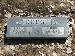
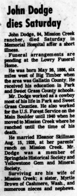
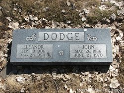
| Birth | : | 26 May 1886 Big Timber, Sweet Grass County, Montana, USA |
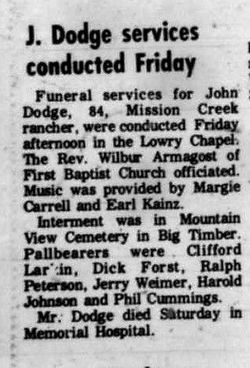
| Death | : | 27 Jul 1970 Livingston, Park County, Montana, USA |
| Burial | : | Green Acres Memorial Park, Scottsdale, Maricopa County, USA |
| Coordinate | : | 33.4530983, -111.9056015 |
| Plot | : | Section 5 Block 2 Lot 1 Grave 5 |
frequently asked questions (FAQ):
-
Where is John R. Dodge's memorial?
John R. Dodge's memorial is located at: Green Acres Memorial Park, Scottsdale, Maricopa County, USA.
-
When did John R. Dodge death?
John R. Dodge death on 27 Jul 1970 in Livingston, Park County, Montana, USA
-
Where are the coordinates of the John R. Dodge's memorial?
Latitude: 33.4530983
Longitude: -111.9056015
Family Members:
Parent
Spouse
Siblings
Nearby Cemetories:
1. Green Acres Memorial Park
Scottsdale, Maricopa County, USA
Coordinate: 33.4530983, -111.9056015
2. Papago Park
Phoenix, Maricopa County, USA
Coordinate: 33.4519000, -111.9443000
3. Phoenix Zoo
Phoenix, Maricopa County, USA
Coordinate: 33.4501220, -111.9496530
4. First Congregational Church Columbarium
Maricopa County, USA
Coordinate: 33.4240000, -111.9378000
5. First United Methodist Church Memorial Garden
Tempe, Maricopa County, USA
Coordinate: 33.4214970, -111.9363410
6. Catholic Church Cemetery
Salt River, Maricopa County, USA
Coordinate: 33.4853210, -111.8686880
7. Scottsdale United Methodist Church Memorial Garden
Scottsdale, Maricopa County, USA
Coordinate: 33.4967330, -111.9183910
8. Salt River Pima-Maricopa Indian Cemetery
Maricopa County, USA
Coordinate: 33.4687000, -111.8502000
9. Episcopal Church of the Epiphany Columbarium
Tempe, Maricopa County, USA
Coordinate: 33.4033720, -111.8932090
10. Saint Augustines Episcopal Church Columbarium
Tempe, Maricopa County, USA
Coordinate: 33.4084100, -111.9345750
11. Prince of Peace Lutheran Church Columbarium
Phoenix, Maricopa County, USA
Coordinate: 33.4909000, -111.9596330
12. University Presbyterian Church Memorial Garden
Tempe, Maricopa County, USA
Coordinate: 33.4000090, -111.9366500
13. Saint Francis Catholic Cemetery
Phoenix, Maricopa County, USA
Coordinate: 33.4733009, -111.9738998
14. First Evangelical Lutheran Church Memorial Garden
Mesa, Maricopa County, USA
Coordinate: 33.4182770, -111.8448890
15. Cross Cut Cemetery
Phoenix, Maricopa County, USA
Coordinate: 33.4514370, -111.9794850
16. City of Mesa Cemetery
Mesa, Maricopa County, USA
Coordinate: 33.4383774, -111.8329163
17. Shepherd of the Hills UCC Memorial Garden
Phoenix, Maricopa County, USA
Coordinate: 33.4950920, -111.9626900
18. Twin Buttes Cemetery
Tempe, Maricopa County, USA
Coordinate: 33.4047700, -111.9667300
19. Valley Presbyterian Church Memorial Garden
Paradise Valley, Maricopa County, USA
Coordinate: 33.5219000, -111.9311000
20. Tempe Double Butte Cemetery
Tempe, Maricopa County, USA
Coordinate: 33.4072189, -111.9756393
21. First United Methodist Church of Mesa Columbarium
Mesa, Maricopa County, USA
Coordinate: 33.4127690, -111.8307530
22. Camelback Cemetery
Paradise Valley, Maricopa County, USA
Coordinate: 33.5243900, -111.9328200
23. Petersen Park
Tempe, Maricopa County, USA
Coordinate: 33.3937500, -111.9612500
24. First Presbyterian Church of Mesa Columbarium
Mesa, Maricopa County, USA
Coordinate: 33.4190950, -111.8225900

