
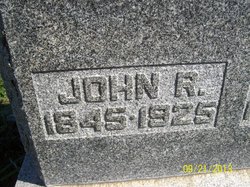
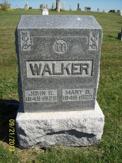
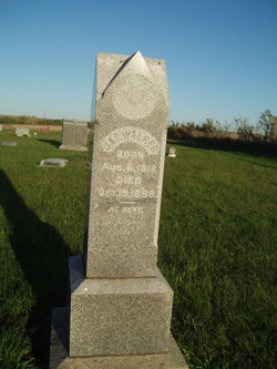
John R. Walker
| Birth | : | 1845 Kentucky, USA |
| Death | : | 1925 Brown County, Kansas, USA |
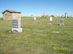
| Burial | : | Island Cemetery, Harrisville, Cheshire County, USA |
| Coordinate | : | 42.9466800, -72.0960100 |
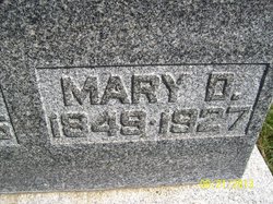
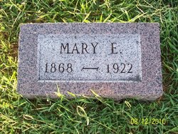
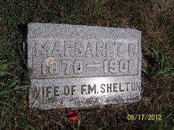
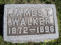
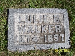
| Description | : | 6/1/1880 census, WALKER household. Padonia Twp., Brown Co., KS John R., 34, farmer, b.KY, dad b.MO, mom b.KY Mary D., 31, wife, b.KY Mary E., 10, dau, b.KY Margarate R., 8, dau, b.KY James T., 7, son, b.KS Lulie B., 5, dau, b.KS Anna F., 3, dau, b.KS (His father, sister & her family, are listed next household -see on his father's page) 4/15/1910 census, WALKER household. Padonia Twp., Brown Co., KS John R., head, 65, marr43yrs, b.KY Mary D., wife, 61, marr43yrs, mother of 9(3 living), b.KY Georgia E., dau, 21, single, b.KS Jefferson, son, 18, b.KS Bessie Shelton*, granddaughter, 15, b.KS *(daughter of Margarate R.) ..John R. Walker, who... Read More |
frequently asked questions (FAQ):
-
Where is John R. Walker's memorial?
John R. Walker's memorial is located at: Island Cemetery, Harrisville, Cheshire County, USA.
-
When did John R. Walker death?
John R. Walker death on 1925 in Brown County, Kansas, USA
-
Where are the coordinates of the John R. Walker's memorial?
Latitude: 42.9466800
Longitude: -72.0960100
Family Members:
Parent
Spouse
Children

Flowers:


Nearby Cemetories:
1. Island Cemetery
Harrisville, Cheshire County, USA
Coordinate: 42.9466800, -72.0960100
2. Saint Denis Cemetery
Harrisville, Cheshire County, USA
Coordinate: 42.9531400, -72.1045900
3. Riverside Cemetery
Chesham, Cheshire County, USA
Coordinate: 42.9348183, -72.1444702
4. Willard Hill Cemetery
Harrisville, Cheshire County, USA
Coordinate: 42.9337006, -72.1520081
5. Dublin Town Cemetery
Dublin, Cheshire County, USA
Coordinate: 42.9064670, -72.0711880
6. Nelson Cemetery
Nelson, Cheshire County, USA
Coordinate: 42.9861200, -72.1281000
7. Nelson Congregational Church Pauper Graves
Nelson, Cheshire County, USA
Coordinate: 42.9899440, -72.1271560
8. Fairwood Bible Institute Cemetery
Dublin, Cheshire County, USA
Coordinate: 42.8984920, -72.1094640
9. East Cemetery
Marlborough, Cheshire County, USA
Coordinate: 42.9317000, -72.1696000
10. Saint Francis Chapel
Marlborough, Cheshire County, USA
Coordinate: 42.8992090, -72.1579800
11. Munsonville Cemetery
Munsonville, Cheshire County, USA
Coordinate: 43.0071200, -72.1577200
12. Pine Ridge Cemetery
Hancock, Hillsborough County, USA
Coordinate: 42.9727800, -71.9865000
13. Hillside Cemetery
Roxbury Center, Cheshire County, USA
Coordinate: 42.9534360, -72.2117930
14. Norway Plain Cemetery
Hancock, Hillsborough County, USA
Coordinate: 42.9743996, -71.9843979
15. East Sullivan Cemetery
East Sullivan, Cheshire County, USA
Coordinate: 42.9953600, -72.1963500
16. Pine Grove Cemetery
Marlborough, Cheshire County, USA
Coordinate: 42.9057100, -72.2073000
17. Graniteville Cemetery
Marlborough, Cheshire County, USA
Coordinate: 42.9057000, -72.2073000
18. Meeting House Cemetery
Marlborough, Cheshire County, USA
Coordinate: 42.8856020, -72.1892240
19. Robb Cemetery
South Stoddard, Cheshire County, USA
Coordinate: 43.0391900, -72.0716500
20. Mount Calvary Cemetery
Marlborough, Cheshire County, USA
Coordinate: 42.9060900, -72.2136300
21. Nye Burying Ground
Roxbury Center, Cheshire County, USA
Coordinate: 42.9393600, -72.2266900
22. Hillside Cemetery
Hancock, Hillsborough County, USA
Coordinate: 42.9844800, -71.9737300
23. Estey Cemetery
Marlborough, Cheshire County, USA
Coordinate: 42.8971000, -72.2113000
24. Sullivan Center Cemetery
Sullivan, Cheshire County, USA
Coordinate: 43.0143433, -72.2217636