
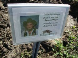
John Raymond “Crazy John” Nispel
| Birth | : | 7 Dec 1944 Beatrice, Gage County, Nebraska, USA |
| Death | : | 29 Aug 2018 North Kansas City, Clay County, Missouri, USA |
| Burial | : | Saint Pauls Evangelical Lutheran Cemetery, Plymouth, Jefferson County, USA |
| Coordinate | : | 40.3074989, -97.0085983 |
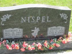
| Description | : | John "Crazy John" Raymond Nispel, 73 December 7, 1944 ~ August 29, 2918 John was born on December 7, 1944 in Beatrice, Nebraska to Raymond and Dorothy (Bengston) Nispel. He was raised on a farm northwest of Plymouth, Nebraska. He was baptized and confirmed, and attended St. Paul’s Evangelical Lutheran Church and School in Plymouth. John graduated from Plymouth High School in 1963. He worked in the construction trades as a member of the carpenter and boiler maker unions. John had special mechanical and welding skills. The Cooper Nuclear Plant in Brownville,... Read More |
frequently asked questions (FAQ):
-
Where is John Raymond “Crazy John” Nispel's memorial?
John Raymond “Crazy John” Nispel's memorial is located at: Saint Pauls Evangelical Lutheran Cemetery, Plymouth, Jefferson County, USA.
-
When did John Raymond “Crazy John” Nispel death?
John Raymond “Crazy John” Nispel death on 29 Aug 2018 in North Kansas City, Clay County, Missouri, USA
-
Where are the coordinates of the John Raymond “Crazy John” Nispel's memorial?
Latitude: 40.3074989
Longitude: -97.0085983
Family Members:
Parent
Flowers:


Nearby Cemetories:
1. Saint Pauls Evangelical Lutheran Cemetery
Plymouth, Jefferson County, USA
Coordinate: 40.3074989, -97.0085983
2. Woodlawn Cemetery
Plymouth, Jefferson County, USA
Coordinate: 40.2991982, -96.9906006
3. Megli-Yost Cemetery
Jefferson County, USA
Coordinate: 40.3064003, -97.0466995
4. Emmanuel Cemetery
Jefferson County, USA
Coordinate: 40.2910995, -97.0466995
5. Immanuel Lutheran Cemetery
Plymouth, Jefferson County, USA
Coordinate: 40.3075430, -96.9529750
6. Old Plymouth Cemetery
Plymouth, Jefferson County, USA
Coordinate: 40.2621994, -97.0235977
7. Kilpatrick Cemetery
Plymouth, Jefferson County, USA
Coordinate: 40.2919006, -96.9338989
8. Peace Lutheran Cemetery
Plymouth, Jefferson County, USA
Coordinate: 40.2868470, -97.0862410
9. Swan Valley Cemetery
Swanton, Saline County, USA
Coordinate: 40.3636017, -97.0832977
10. Plummers Branch Cemetery
Swanton, Saline County, USA
Coordinate: 40.3866997, -97.0314026
11. Saint Pauls Church of Christ Cemetery
Jefferson County, USA
Coordinate: 40.2478480, -97.0808630
12. Hildebrandt Cemetery
Jansen, Jefferson County, USA
Coordinate: 40.2225750, -97.0476330
13. Zion Lutheran Cemetery
Harbine, Jefferson County, USA
Coordinate: 40.2346610, -96.9350780
14. First Trinity Lutheran Cemetery
Beatrice, Gage County, USA
Coordinate: 40.3053600, -96.8794400
15. Sparks Cemetery
Beatrice, Gage County, USA
Coordinate: 40.2485180, -96.8984970
16. Harbine Cemetery
Harbine, Jefferson County, USA
Coordinate: 40.2042007, -96.9717026
17. Oak Grove Cemetery
De Witt, Saline County, USA
Coordinate: 40.4049988, -96.9483032
18. Bower Cemetery
Jefferson County, USA
Coordinate: 40.2621994, -97.1517029
19. South Fork Cemetery
Saline County, USA
Coordinate: 40.3792000, -97.1331024
20. Thiessen Cemetery
Jansen, Jefferson County, USA
Coordinate: 40.1899650, -97.0640780
21. Freeman Cemetery
Beatrice, Gage County, USA
Coordinate: 40.2966933, -96.8435666
22. Ellis Cemetery
Beatrice, Gage County, USA
Coordinate: 40.2260017, -96.8785019
23. Pleasant View Cemetery
Jefferson County, USA
Coordinate: 40.3204500, -97.1795800
24. Hope Church Cemetery
Harbine, Jefferson County, USA
Coordinate: 40.1826480, -96.9540828