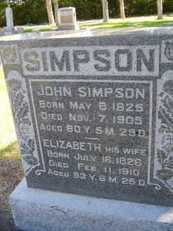
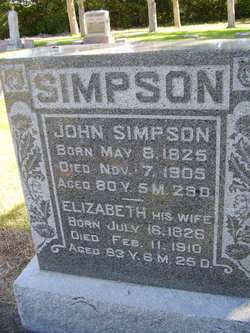
John Simpson
| Birth | : | 8 May 1825 Ireland |
| Death | : | 7 Nov 1905 Blue Hill, Webster County, Nebraska, USA |
| Burial | : | St. Audries Churchyard, West Quantoxhead, West Somerset District, England |
| Coordinate | : | 51.1688420, -3.2717650 |
| Plot | : | NW section Lot 188 |
| Description | : | John Simpson died in Blue Hill, Webster Co. NE 1905—Death of John Simpson John Simpson died at his home in this city Tuesday afternoon after an extended illness with dropsy. The funeral service was held Thursday afternoon at 2 o’clock at Presbyterian Church. Rev. Bretthouwer preaching the sermon, in the presence of a large congregation of mourning friends and relatives. The interment was made in the Blue Hill cemetery. John Simpson was born in Ireland May 8, 1825, died Nov. 7th, 1905, at the age of 80 yrs. And 6 months. He was married to Elizabeth Jenkins Dec. 19,... Read More |
frequently asked questions (FAQ):
-
Where is John Simpson's memorial?
John Simpson's memorial is located at: St. Audries Churchyard, West Quantoxhead, West Somerset District, England.
-
When did John Simpson death?
John Simpson death on 7 Nov 1905 in Blue Hill, Webster County, Nebraska, USA
-
Where are the coordinates of the John Simpson's memorial?
Latitude: 51.1688420
Longitude: -3.2717650
Family Members:
Spouse
Children
Flowers:
Nearby Cemetories:
1. St. Audries Churchyard
West Quantoxhead, West Somerset District, England
Coordinate: 51.1688420, -3.2717650
2. Saint George Churchyard
Bicknoller, West Somerset District, England
Coordinate: 51.1472610, -3.2722430
3. St. George's Churchyard
Sampford Brett, West Somerset District, England
Coordinate: 51.1538990, -3.3033380
4. St. Mary's Churchyard
East Quantoxhead, West Somerset District, England
Coordinate: 51.1855220, -3.2370690
5. St Peter's Churchyard
Williton, West Somerset District, England
Coordinate: 51.1584870, -3.3235670
6. St Mary's Churchyard
Kilve, West Somerset District, England
Coordinate: 51.1883100, -3.2223530
7. St. Mary's Churchyard
Holford, West Somerset District, England
Coordinate: 51.1627900, -3.2074238
8. Watchet Town Cemetery
Watchet, West Somerset District, England
Coordinate: 51.1745790, -3.3379850
9. St Decuman's Churchyard
Watchet, West Somerset District, England
Coordinate: 51.1757020, -3.3383800
10. St. Mary of Stogumber Churchyard
Stogumber, West Somerset District, England
Coordinate: 51.1276170, -3.2902340
11. All Saints Churchyard
Monksilver, West Somerset District, England
Coordinate: 51.1287770, -3.3262800
12. St. Nicholas's Churchyard
Holford, West Somerset District, England
Coordinate: 51.1902700, -3.1949170
13. Holy Ghost Churchyard
Crowcombe, West Somerset District, England
Coordinate: 51.1232260, -3.2293260
14. All Saints Churchyard
Dodington, West Somerset District, England
Coordinate: 51.1583770, -3.1854620
15. St. Andrew's Churchyard
Lilstock, West Somerset District, England
Coordinate: 51.1971070, -3.1936420
16. St. Mary's Churchyard
Stringston, West Somerset District, England
Coordinate: 51.1748960, -3.1795460
17. St Mary Church
Nettlecombe, West Somerset District, England
Coordinate: 51.1312930, -3.3491000
18. St. Andrew's Parish of Old Cleeve Churchyard
Old Cleeve, West Somerset District, England
Coordinate: 51.1683560, -3.3733090
19. St. Martin de Tours Churchyard
Elworthy, West Somerset District, England
Coordinate: 51.1066110, -3.3113586
20. Over Stowey Cemetery
Over Stowey, Sedgemoor District, England
Coordinate: 51.1404020, -3.1661850
21. St Peter and St Paul Churchyard
Over Stowey, Sedgemoor District, England
Coordinate: 51.1399680, -3.1656040
22. Burton Baptist Chapel
Stogursey, West Somerset District, England
Coordinate: 51.1910560, -3.1560340
23. Nether Stowey Cemetery
Nether Stowey, Sedgemoor District, England
Coordinate: 51.1498667, -3.1530087
24. St. Mary's Churchyard
Nether Stowey, Sedgemoor District, England
Coordinate: 51.1502280, -3.1494270


