
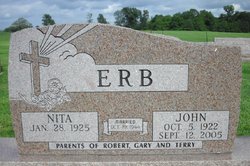
John Stanley Erb
| Birth | : | 5 Oct 1922 |
| Death | : | 12 Sep 2005 |
| Burial | : | St Michael Churchyard, York, York Unitary Authority, England |
| Coordinate | : | 53.9577900, -1.0825600 |
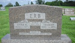
| Description | : | Kalona–John Stanley Erb was born October 5, 1922 near Wellman, Iowa in Iowa County, the son of Truman and Anna Marie Brenneman Erb. He attended White Hall Schoo near Wellmanl. John was united in marriage to Nita Brenneman October 19, 1944 at the Lower Deer Creek Church rural Kalona, Iowa. The couple farmed in the Wellman area for more than 40 years, retiring in 1985. In 1988 they moved to their home in Kalona. John enjoyed spending time with his family especially his grandchildren, fishing, traveling and his favorite hobby was working and spending time on the farm with his... Read More |
frequently asked questions (FAQ):
-
Where is John Stanley Erb's memorial?
John Stanley Erb's memorial is located at: St Michael Churchyard, York, York Unitary Authority, England.
-
When did John Stanley Erb death?
John Stanley Erb death on 12 Sep 2005 in
-
Where are the coordinates of the John Stanley Erb's memorial?
Latitude: 53.9577900
Longitude: -1.0825600
Family Members:
Parent

Siblings
Flowers:


Nearby Cemetories:
1. St Michael Churchyard
York, York Unitary Authority, England
Coordinate: 53.9577900, -1.0825600
2. Saint Peter's
York, York Unitary Authority, England
Coordinate: 53.9577400, -1.0822600
3. Carmelite Friary of York (Defunct)
York, York Unitary Authority, England
Coordinate: 53.9577020, -1.0822860
4. St Peter the Little (Defunct)
York, York Unitary Authority, England
Coordinate: 53.9585310, -1.0821170
5. All Saints Pavement Churchyard
York, York Unitary Authority, England
Coordinate: 53.9581090, -1.0808820
6. St. Mary Castlegate Churchyard
York, York Unitary Authority, England
Coordinate: 53.9570800, -1.0804370
7. St John Churchyard
York, York Unitary Authority, England
Coordinate: 53.9574440, -1.0854510
8. St Helen Davygate Church Cemetery
York, York Unitary Authority, England
Coordinate: 53.9596460, -1.0830390
9. St Martin le Grand Churchyard
York, York Unitary Authority, England
Coordinate: 53.9593870, -1.0843800
10. St Sampson Churchyard
York, York Unitary Authority, England
Coordinate: 53.9597440, -1.0813060
11. St Crux Churchyard
York, York Unitary Authority, England
Coordinate: 53.9589890, -1.0795460
12. All Saints North Street Churchyard
York, York Unitary Authority, England
Coordinate: 53.9584400, -1.0862400
13. Greyfriars Abbey Church (Defunct)
York, York Unitary Authority, England
Coordinate: 53.9553090, -1.0814240
14. Holy Trinity Kings Court Churchyard
York, York Unitary Authority, England
Coordinate: 53.9599760, -1.0800800
15. St Helen Churchyard
York, York Unitary Authority, England
Coordinate: 53.9603030, -1.0841970
16. Central Methodist Hall
York, York Unitary Authority, England
Coordinate: 53.9594090, -1.0788330
17. St Martin cum Gregory Churchyard
York, York Unitary Authority, England
Coordinate: 53.9572500, -1.0871400
18. St Mary Bishophill Senior Churchyard
York, York Unitary Authority, England
Coordinate: 53.9551780, -1.0849680
19. Friends Burial Ground
York, York Unitary Authority, England
Coordinate: 53.9550140, -1.0846700
20. Augustinian Friary, York (Nonextant)
York, York Unitary Authority, England
Coordinate: 53.9601683, -1.0860521
21. St Mary Bishophill Junior Churchyard
York, York Unitary Authority, England
Coordinate: 53.9558890, -1.0869950
22. St Saviour Churchyard
York, York Unitary Authority, England
Coordinate: 53.9596100, -1.0780000
23. St Crux Hungate Burial Ground
York, York Unitary Authority, England
Coordinate: 53.9593540, -1.0774470
24. Holy Trinity Goodramgate Churchyard
York, York Unitary Authority, England
Coordinate: 53.9609810, -1.0804640