
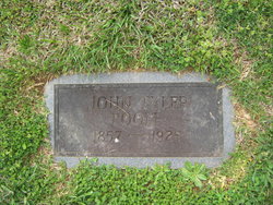
John Tyler Poole
| Birth | : | 13 May 1857 Randolph County, North Carolina, USA |
| Death | : | 12 Apr 1925 Siler City, Chatham County, North Carolina, USA |
| Burial | : | Pleasant Grove Christian Church Cemetery, Coleridge, Randolph County, USA |
| Coordinate | : | 35.5857160, -79.5783140 |
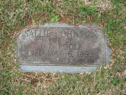
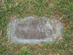
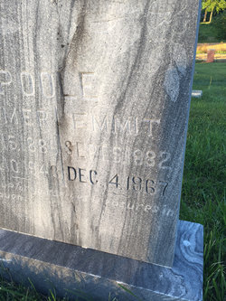
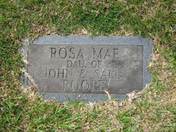
| Description | : | NCDC shows his birth as being 13 MAY 1856 and his death date being 12 APR 1926. Father listed as unknown, mother listed as Sally Poole. He was a farmer and died from stomach cancer. Marriage 1 Sally Johnson *Married 31 JAN 1878 in Randolph County, North Carolina Children Malissa Jane Poole b: 22 AUG 1880 Emmit W Poole b: 5 SEPT 1882 Parkie Poole John Robert Poole b: 12 DEC 1886 Arthur Milton Poole b: 12 JAN 1888 Lena Annie Poole b: 5 Jul 1891 Rosa Mae Pool b: May 1893 |
frequently asked questions (FAQ):
-
Where is John Tyler Poole's memorial?
John Tyler Poole's memorial is located at: Pleasant Grove Christian Church Cemetery, Coleridge, Randolph County, USA.
-
When did John Tyler Poole death?
John Tyler Poole death on 12 Apr 1925 in Siler City, Chatham County, North Carolina, USA
-
Where are the coordinates of the John Tyler Poole's memorial?
Latitude: 35.5857160
Longitude: -79.5783140
Family Members:
Spouse
Children

Flowers:


Nearby Cemetories:
1. Pleasant Grove Christian Church Cemetery
Coleridge, Randolph County, USA
Coordinate: 35.5857160, -79.5783140
2. Maple Springs United Methodist Church Cemetery
Ramseur, Randolph County, USA
Coordinate: 35.6190030, -79.5871860
3. Pleasant Hill United Methodist Church Cemetery
Seagrove, Randolph County, USA
Coordinate: 35.5641190, -79.6124860
4. Bennett Baptist Church Cemetery
Bennett, Chatham County, USA
Coordinate: 35.5602350, -79.5418390
5. Glover United Church of Christ
Chatham County, USA
Coordinate: 35.6016667, -79.5283333
6. Antioch Christian Church Cemetery
Seagrove, Randolph County, USA
Coordinate: 35.5847980, -79.6361780
7. Mount Zion United Methodist Church Cemetery
Randolph County, USA
Coordinate: 35.5310430, -79.5624010
8. Deaton Family Cemetery
Chatham County, USA
Coordinate: 35.5353440, -79.5469330
9. Riverside Baptist Church Cemetery
Seagrove, Randolph County, USA
Coordinate: 35.5337430, -79.6099330
10. John D. Scott Graveyard
Harpers Crossroads, Chatham County, USA
Coordinate: 35.5519400, -79.5188900
11. Waddell Memorial Chapel Cemetery
Randolph County, USA
Coordinate: 35.5256450, -79.5795590
12. Deep River Baptist Church Cemetery
Ramseur, Randolph County, USA
Coordinate: 35.6388700, -79.6247100
13. Maness Family Cemetery
Coleridge, Randolph County, USA
Coordinate: 35.5315700, -79.6235700
14. Bray Cemetery
Bear Creek, Chatham County, USA
Coordinate: 35.6392430, -79.5295760
15. Beulah Baptist Church Cemetery
Randolph County, USA
Coordinate: 35.5183320, -79.5662690
16. Shiloh Baptist Church Cemetery
Ramseur, Randolph County, USA
Coordinate: 35.6115112, -79.6561737
17. Concord Cemetery
Coleridge, Randolph County, USA
Coordinate: 35.6525002, -79.6042023
18. Purvis Cemetery
Bennett, Chatham County, USA
Coordinate: 35.5184244, -79.5488155
19. Lane-Moon Cemetery
Bear Creek, Chatham County, USA
Coordinate: 35.6461100, -79.5305600
20. Mount Olivet United Methodist Church Cemetery
Coleridge, Randolph County, USA
Coordinate: 35.5527400, -79.6593200
21. James Scott Family Cemetery
Chatham County, USA
Coordinate: 35.5494444, -79.4977778
22. Fall Creek Baptist Cemetery
Bennett, Chatham County, USA
Coordinate: 35.5272540, -79.5158190
23. Brush Creek Baptist Church Cemetery
Bear Creek, Chatham County, USA
Coordinate: 35.6527557, -79.5240936
24. Chesley Jones Family Cemetery
Bear Creek, Chatham County, USA
Coordinate: 35.5322300, -79.5043200