
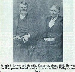

Joseph Power “Uncle Joe” Lewis
| Birth | : | 14 Mar 1811 Bracken County, Kentucky, USA |
| Death | : | 11 Apr 1889 Custer County, Nebraska, USA |
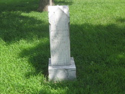
| Burial | : | Old Saint Davids Episcopal Church Cemetery, Cheraw, Chesterfield County, USA |
| Coordinate | : | 34.6956140, -79.8794250 |
| Plot | : | Block 16 |
| Inscription | : | JOSEPH P. LEWIS DIED APR. 11, 1889 AGED 73 Y 27 D |
| Description | : | from The History of Hendricks County, Indiana (Chicago: Interstate Publishing, 1885)--Center Township, pages 527-528: Joseph P. Lewis was born in Bracken County, Ky. While he was a lad his parents moved to Indiana, stopping in Fayette and Rush counties. Joseph went back to Kentucky and was married to Louisa Leak in June, 1834. He moved to Hendricks County in 1835, and lived there continuously until his removal to Nebraska April 1, 1885, where he went to join his children in Custer County. He could relate many interesting experiences of pioneer life, such as how the settlers beat their corn into meal... Read More |
frequently asked questions (FAQ):
-
Where is Joseph Power “Uncle Joe” Lewis's memorial?
Joseph Power “Uncle Joe” Lewis's memorial is located at: Old Saint Davids Episcopal Church Cemetery, Cheraw, Chesterfield County, USA.
-
When did Joseph Power “Uncle Joe” Lewis death?
Joseph Power “Uncle Joe” Lewis death on 11 Apr 1889 in Custer County, Nebraska, USA
-
Where are the coordinates of the Joseph Power “Uncle Joe” Lewis's memorial?
Latitude: 34.6956140
Longitude: -79.8794250
Family Members:
Parent
Spouse
Siblings

Children
Flowers:


Nearby Cemetories:
1. Pee Dee Union Baptist Church Cemetery
Cheraw, Chesterfield County, USA
Coordinate: 34.6968440, -79.8775160
2. Erasmus Powe Family Cemetery
Cheraw, Chesterfield County, USA
Coordinate: 34.7041400, -79.8822950
3. Foundry Hill Cemetery
Cheraw, Chesterfield County, USA
Coordinate: 34.6957350, -79.8998800
4. Gillespie - Shipp Family Graveyard
Wallace, Marlboro County, USA
Coordinate: 34.7179060, -79.8657610
5. Wallace Baptist Church Cemetery
Wallace, Marlboro County, USA
Coordinate: 34.7199530, -79.8609130
6. Chatham Hill Memorial Gardens
Cheraw, Chesterfield County, USA
Coordinate: 34.6719017, -79.9019012
7. Mission of Faith Church Cemetery
Wallace, Marlboro County, USA
Coordinate: 34.7246090, -79.8598550
8. Greater White Creek Baptist Church Cemetery
Wallace, Marlboro County, USA
Coordinate: 34.7346600, -79.8667400
9. Fisher Hill Community Cemetery
Cheraw, Chesterfield County, USA
Coordinate: 34.6738360, -79.9319040
10. Progressive Church of Our Lord Jesus Christ Cemete
Cheraw, Chesterfield County, USA
Coordinate: 34.6910300, -79.9387430
11. J. C. Broome Memorial Garden
Cheraw, Chesterfield County, USA
Coordinate: 34.6753830, -79.9346970
12. Hickory Grove Road Cemetery
Wallace, Marlboro County, USA
Coordinate: 34.6950640, -79.8162270
13. Robinson Zion Church
Cheraw, Chesterfield County, USA
Coordinate: 34.7328090, -79.9323420
14. Prince Of Peace Church Cemetery
Cheraw, Chesterfield County, USA
Coordinate: 34.7076230, -79.9484660
15. Smith Family Cemetery
Wallace, Marlboro County, USA
Coordinate: 34.7216060, -79.8162530
16. Faith Freewill Baptist Church Cemetery
Cheraw, Chesterfield County, USA
Coordinate: 34.6717450, -79.9451980
17. Goodman Creek Missionary Baptist Church
Cheraw, Chesterfield County, USA
Coordinate: 34.7356390, -79.9347530
18. Pleasant Grove United Methodist Church Cemetery
Cheraw, Chesterfield County, USA
Coordinate: 34.7048630, -79.9539520
19. Ebenezer United Methodist Church Cemetery
Wallace, Marlboro County, USA
Coordinate: 34.7326498, -79.8078380
20. Oak Grove United Methodist Church Cemetery
Wallace, Marlboro County, USA
Coordinate: 34.7430992, -79.8174973
21. Montrose Cemetery
Chesterfield County, USA
Coordinate: 34.6255989, -79.8842010
22. True Gospel Emanuel Holiness Church Cemetery
Wallace, Marlboro County, USA
Coordinate: 34.7146900, -79.7958800
23. Gibson Family Cemetery
Wallace, Marlboro County, USA
Coordinate: 34.7425300, -79.8137700
24. Smithville Cemetery
Chesterfield County, USA
Coordinate: 34.7047005, -79.9669037