
Joseph Rich Earl
| Birth | : | 26 Apr 1835 Illinois, USA |
| Death | : | 4 Nov 1898 Alliance, Box Butte County, Nebraska, USA |
| Burial | : | St. Michael's Churchyard, Monkton Combe, Bath and North East Somerset Unitary Authority, England |
| Coordinate | : | 51.3559540, -2.3285700 |
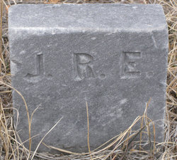
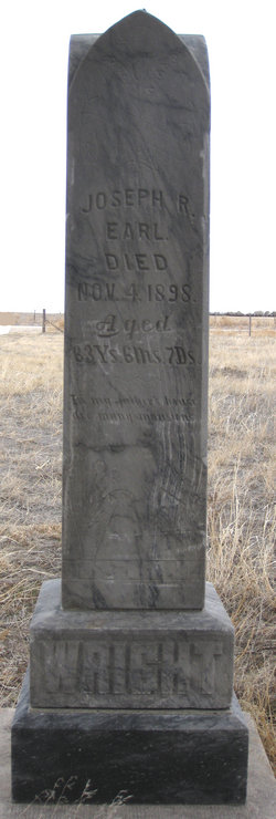
| Inscription | : | Joseph R. Earl died November 4, 1898, 63yrs, 6 mos., 7 days. "In my Father's house are many mansions." |
| Description | : | (OBITUARY FROM ALLIANCE TIMES, FRIDAY, NOV. 4, 1898) " Joseph Rich Earl, father of Mrs. Vol Wright died this morning from throat and lung trouble, at the home of his daughter, west of town. Other particulars are not at hand." Excerpt from "City of Alliance and Box Butte County Centennial (1988): Minerva Earl was only sixteen years old when she became Mrs. Vol Wright. Her father (Joseph Earl) was a widower so lived with them and came with them to Box Butte County, Nebraska to file for homestead land. The trip was made by team and... Read More |
frequently asked questions (FAQ):
-
Where is Joseph Rich Earl's memorial?
Joseph Rich Earl's memorial is located at: St. Michael's Churchyard, Monkton Combe, Bath and North East Somerset Unitary Authority, England.
-
When did Joseph Rich Earl death?
Joseph Rich Earl death on 4 Nov 1898 in Alliance, Box Butte County, Nebraska, USA
-
Where are the coordinates of the Joseph Rich Earl's memorial?
Latitude: 51.3559540
Longitude: -2.3285700
Family Members:
Parent

Spouse
Siblings
Children
Flowers:


Nearby Cemetories:
1. St. Michael's Churchyard
Monkton Combe, Bath and North East Somerset Unitary Authority, England
Coordinate: 51.3559540, -2.3285700
2. Union Chapel
Combe Down, Bath and North East Somerset Unitary Authority, England
Coordinate: 51.3594751, -2.3443662
3. Prior Park College
Bath, Bath and North East Somerset Unitary Authority, England
Coordinate: 51.3645990, -2.3442400
4. Jewish Burial Ground
Combe Down, Bath and North East Somerset Unitary Authority, England
Coordinate: 51.3599170, -2.3534670
5. Midford Burial Ground
Bath, Bath and North East Somerset Unitary Authority, England
Coordinate: 51.3394360, -2.3391424
6. St John the Evangelist Cemetery
Bath, Bath and North East Somerset Unitary Authority, England
Coordinate: 51.3696700, -2.3487400
7. Bath Abbey Cemetery
Widcombe, Bath and North East Somerset Unitary Authority, England
Coordinate: 51.3712850, -2.3483060
8. St Thomas à Becket's Church
Widcombe, Bath and North East Somerset Unitary Authority, England
Coordinate: 51.3734250, -2.3465560
9. Unitarian Chapel Burial Ground
Widcombe, Bath and North East Somerset Unitary Authority, England
Coordinate: 51.3704650, -2.3539270
10. St. Mary The Virgin Churchyard
Bathwick, Bath and North East Somerset Unitary Authority, England
Coordinate: 51.3759930, -2.3411930
11. Smallcombe Vale Cemetery
Bathwick, Bath and North East Somerset Unitary Authority, England
Coordinate: 51.3757400, -2.3429400
12. Freshford Cemetery
Freshford, Bath and North East Somerset Unitary Authority, England
Coordinate: 51.3379620, -2.3082970
13. Saint Peters Churchyard
Freshford, Bath and North East Somerset Unitary Authority, England
Coordinate: 51.3400570, -2.3033340
14. Quaker Burial Ground
Widcombe, Bath and North East Somerset Unitary Authority, England
Coordinate: 51.3744350, -2.3498460
15. St. James' Churchyard
South Stoke, Bath and North East Somerset Unitary Authority, England
Coordinate: 51.3497220, -2.3652780
16. St. Mary's Churchyard
Claverton, Bath and North East Somerset Unitary Authority, England
Coordinate: 51.3757560, -2.3061500
17. Claverton Cemetery
Bath, Bath and North East Somerset Unitary Authority, England
Coordinate: 51.3758190, -2.3060720
18. Abbey & St James' Graveyard for the Poor
Widcombe, Bath and North East Somerset Unitary Authority, England
Coordinate: 51.3753550, -2.3545640
19. Old Baptist Burial Ground
Walcot, Bath and North East Somerset Unitary Authority, England
Coordinate: 51.3755070, -2.3544360
20. Baptist Burial Ground
Widcombe, Bath and North East Somerset Unitary Authority, England
Coordinate: 51.3764216, -2.3556947
21. Bath Union Workhouse Graveyard
Bath, Bath and North East Somerset Unitary Authority, England
Coordinate: 51.3584160, -2.3711140
22. Saint Mark's Churchyard
Widcombe, Bath and North East Somerset Unitary Authority, England
Coordinate: 51.3766660, -2.3588010
23. St Mary Magdalen Chapel
Widcombe, Bath and North East Somerset Unitary Authority, England
Coordinate: 51.3760486, -2.3643405
24. Old Orchard Street Catholic Burial Vault
Bath, Bath and North East Somerset Unitary Authority, England
Coordinate: 51.3800370, -2.3579910