
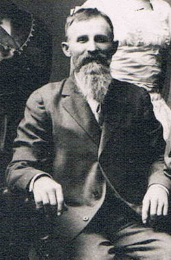
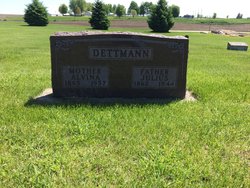

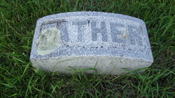
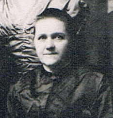
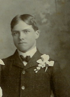
Julius Christoph Dettmann
| Birth | : | 9 Jan 1862 Clayton County, Iowa, USA |
| Death | : | 12 May 1944 Clayton County, Iowa, USA |
| Burial | : | National Cemetery, National, Clayton County, USA |
| Coordinate | : | 42.9536018, -91.2902985 |
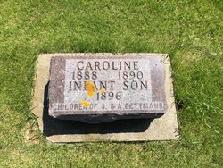
| Description | : | Julius Dettman Funeral services for Julius Dettman, 82 who died at his home here last Friday, May 12, 1944, due to infirmities of old age, were held at St. John’s Lutheran church Monday afternoon. The Rev. H.M. Adix conducted the services. Burial was in the cemetery in National. Julius Dettman, son of Mr. and Mrs. John Dettman, was born Jan. 9, 1862 near Garnavillo, His youth and manhood was spent in the Garnavillo vicinity and March 29, 1887 he was married to Miss Alvina Hamann. The couple moved to a farm north of National where... Read More |
frequently asked questions (FAQ):
-
Where is Julius Christoph Dettmann's memorial?
Julius Christoph Dettmann's memorial is located at: National Cemetery, National, Clayton County, USA.
-
When did Julius Christoph Dettmann death?
Julius Christoph Dettmann death on 12 May 1944 in Clayton County, Iowa, USA
-
Where are the coordinates of the Julius Christoph Dettmann's memorial?
Latitude: 42.9536018
Longitude: -91.2902985
Family Members:
Parent
Spouse
Siblings
Children

Flowers:


Nearby Cemetories:
1. National Cemetery
National, Clayton County, USA
Coordinate: 42.9536018, -91.2902985
2. Giard Cemetery
Farmersburg, Clayton County, USA
Coordinate: 42.9933014, -91.3080978
3. Bismark Cemetery
Farmersburg, Clayton County, USA
Coordinate: 42.9790000, -91.3500000
4. Farmersburg-Wagner Cemetery
Farmersburg, Clayton County, USA
Coordinate: 42.9481010, -91.3700027
5. Eastman Cemetery
McGregor, Clayton County, USA
Coordinate: 43.0010000, -91.2190000
6. Clayton Center Cemetery
Clayton Center, Clayton County, USA
Coordinate: 42.8841705, -91.3225021
7. Zion Lutheran Cemetery
Clayton Center, Clayton County, USA
Coordinate: 42.8841705, -91.3249969
8. County Home Cemetery
Clayton Center, Clayton County, USA
Coordinate: 42.8916702, -91.3499985
9. Railroad Employee Cemetery
Giard, Clayton County, USA
Coordinate: 43.0305395, -91.3140229
10. Norwegian Church Cemetery
McGregor, Clayton County, USA
Coordinate: 42.9644400, -91.1764100
11. First Evangelical Lutheran Church Cemetery
McGregor, Clayton County, USA
Coordinate: 42.9718000, -91.1760000
12. Colony Catholic Cemetery (Defunct)
Read Township, Clayton County, USA
Coordinate: 42.8830000, -91.3580000
13. Moody Cemetery
McGregor, Clayton County, USA
Coordinate: 43.0030594, -91.1886063
14. Buell Park Cemetery
Mendon Township, Clayton County, USA
Coordinate: 43.0168226, -91.1999590
15. Garnavillo Community Cemetery
Garnavillo, Clayton County, USA
Coordinate: 42.8656000, -91.2422100
16. Garnavillo Cemetery
Garnavillo, Clayton County, USA
Coordinate: 42.8660300, -91.2390100
17. Saint Joseph Cemetery
Garnavillo, Clayton County, USA
Coordinate: 42.8628006, -91.2502975
18. Walton Cemetery
McGregor, Clayton County, USA
Coordinate: 43.0216270, -91.1909350
19. Gooding Cemetery
Wagner Township, Clayton County, USA
Coordinate: 42.9869490, -91.4191570
20. Pleasant Grove Cemetery
McGregor, Clayton County, USA
Coordinate: 43.0266991, -91.1949997
21. Saint Marys Catholic Church Cemetery
McGregor, Clayton County, USA
Coordinate: 43.0213735, -91.1834632
22. Norway Lutheran Church Cemetery
Saint Olaf, Clayton County, USA
Coordinate: 42.9352798, -91.4302826
23. Clayton Cemetery
Clayton, Clayton County, USA
Coordinate: 42.9043999, -91.1641998
24. Saint Wenceslaus Cemetery
McGregor, Clayton County, USA
Coordinate: 43.0593987, -91.3142014