| Description |
: |
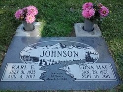
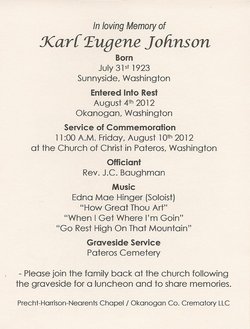
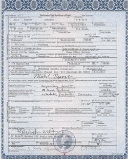
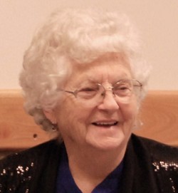
Karl Eugene Johnson, 89 of Okanogan passed away at his Daughters home in Okanogan August, 4, 2012.
He was born July 31, 1923 in Sunnyside, WA to Aaron and Emma Johnson.
He was raised in Sunnyside, WA until 1926 when the family moved to Kennewick, where his Dad raised a five acre garden, by age five Karl was planting potatoes and weeding the garden along with two other brothers. In 1934 the family moved to Twisp, WA and took over His Grandfathers Ranch.
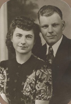
In 1946 He met Edna Mae Burns, they married March 5, 1946, She preceded...
Read More
|
Karl Eugene Johnson, 89 of Okanogan passed away at his Daughters home in Okanogan August, 4, 2012.
He was born July 31, 1923 in Sunnyside, WA to Aaron and Emma Johnson.
He was raised in Sunnyside, WA until 1926 when the family moved to Kennewick, where his Dad raised a five acre garden, by age five Karl was planting potatoes and weeding the garden along with two other brothers. In 1934 the family moved to Twisp, WA and took over His Grandfathers Ranch.
In 1946 He met Edna Mae Burns, they married March 5, 1946, She preceded Him in death September 10, 2011, March 12, 2011 they Celebrated 65 years together, they first lived in Carlton, then moved to Winthrop in 1955, they then settled at Home in Brewster in 1972 for many years, until moving to Okanogan in 2005 next to their Daughter Laurie.
Karl had numerous jobs along with farming, hauling apples in the fall and did contracting work for the Forest Service, using his equipment on fires, about 1973 they bought ten acres on the Bridgeport Bar where he planted pears and started Johnson's Backhoe Service. There wasn't anything he wouldn't try, a job he hated, or a fruit stand he would pass up, he liked watermelon, cantaloupe and sweet cherry pie, and the last few years he raised a large garden.
He raised 5 Children and enjoyed spending time with his Children, Grandchildren and Great Grandchildren.
He is survived by two Sons Bill Johnson (Kathy) of Omak, Bob Johnson (Gwen) of Bridgeport, three Daughters, Sharon Lester (Bill) of Port Orchard, Bunny Johnson (J.C.) of Bridgeport, and Laurie Morgan (A.C.) of Okanogan, 14 Grandchildren and 16 Great Grandchildren, one Brother Donald Johnson, and two Sisters Dorothy Haines, and Vera Baughman
He was preceded in death by His spouse of 65 years Edna Mae, his parents Aaron and Emma Johnson, 4 Brothers, His Grandparents and many Cousins.
A memorial service is planned at 11 a.m. Friday, August 10, 2012 at the Church of Christ on 128 N. Independence Street, in Pateros, WA with Inurnment Services to be held immediately after at the Pateros Cemetery.
A potluck Celebration of Life will follow at the Church of Christ in Pateros, WA
In lieu of flowers a donation can be made to the charity of your choice in Karl's name.
Precht-Harrison Nearants Chapel is in charge of arrangements.
Children:
William Eugene Johnson 1947
Sharon Karlene Johnson 1948
Florence Dianne Johnson 1949
Robert Karl Johnson 1956
Laurie Lynne Johnson 1957
Home in the Methow and Okanogan Valleys, by Karl Johnson
Though I was born in Sunnyside, Washington as the second child of
Aaron and Emma Johnson in 1923, I have always thought of the Methow
and Okanogan Valleys as my home.
Some of my earliest remembrances center around our five acre home
place just outside of Kennewick. Dad also rented ten acres one mile
down the road, and rented another ten acres further on. All of us
seven children who were born there in Kennewick helped in the
cultivation of the strawberries, asparagus, corn, tomatoes and other
crops that Dad sold to the cannery. Dad had a second job besides the
ranch, working at the flour mill at nights. As we pulled weeds,
helped with the rill irrigation and other chores, we lived up to our
family motto, "Our play is the work".
Dad was great in managing. The fresh straw to put in the chicken
house we hauled in a Model T from the Horse Heaven country. It was
also used for the turkeys. From the flock of Leghorn hens, we sold
eggs: I remember having to candle them. Dad and his friend Charley
Mizer had a yearly contest going to see who could raise the most
potatoes.
On the side for spending money, we children used to go up and
down the fence rows and county roads picking asparagus. Dad had an
asparagus field and the fence line next to it had the best picking:
sometimes we would slip in the field and get a little extra asparagus.
This brought us two bits a crate. One day while picking, another of
Dad's friends, Sam Wiggins, came by and stopped to talk. When Sam's
son rode up on his bicycle, I went over, borrowed the bike, and with a
little wobbling learned to ride the bike on the big hill there. At
that time I must have been around eight to ten years old.
In 19J4 a momentous change came to our family. My father Aaron
was the second son of James and Ivy Johnson, pioneers in the Methow
Valley of Washington and had grown up there on the Home Place in the
rolling hills just east of Twisp. James farmed the place from 1888
until 1934 when it got too much for him to care for. To contact his
son, James rode a saddle horse from Twisp to Kennewick a distance of
around 130 miles to see if he could get Aaron and wife Emma and family
to move to Twisp and take over the home ranch there. It was the first
time Aaron's children had seen their grandfather, and with his long
white beard, he reminded them of "Santa Claus".
Aaron and Emma decided to sell their Kennewick place; and to make
the move, they loaded their Model A truck with their belongings and
the seven children and started for Twisp. When they got to Knapp's
Hill Aaron had to back up the grade as the old Model A had more power
in reverse than in the other gears. It was dark and had snowed by
the time they got to Twisp, so Aaron had to walk up to the house to
get a team of horses to pull them up the hill. When the truck was
finally pulled up to the house and the horses unhooked, they ran
away!
In 1934 while living in Twisp, our folks had gone to town. We
boys had just got out the 22 to shoot magpies when we saw our parents
returning. My brother Clarence took the magazine out of the 22,
kicked the shells out, but didn't know there was still a bullet in the chamber. And in the excitement, he pulled the trigger. The bullet
went into the fleshy part of my thumb and came out on the wrist. Dad
just put turpentine on it. For a long time I could hardly use the
hand, but with the doctor's advice to "work the heck out of the hand",
it gradually became more usable. I still have the scar today •..
My remembrance of the Twisp Home Place is of the large amount of
work that fell to us older boys. Our daily routine was to harness the
horses, work in the fields all day, unharness the horses; then two
times a-day we had to milk, separate and feed the calves. For haying
Dad hired hay hands for about thirty days in the summertime. We
resented the fact that after the hayers were through for the day, we
boys still had the chores to do. During the haying, we boys drove the
horses and helped load the hay slips that hauled the hay from the
fields to the stack. Dad could stack more hay and faster than any man
I know of. Even when it was 100 degrees, he would stand there
hollering at us, "More Hay"; I can hear him yet! After haying came
the good part of the day--we-would jump on the saddle horses and ride
down to the irrigation ditch for a cool swim.
The 4th of July was a big event in the Valley. We always tried
to be through with the haying by the 3th, and for the celebration Dad
would give each of us $5.00. At home the family always had a big
dinner with lots of fried chicken and a three-gallon freezer of home-
made ice cream. i
I remember Mom as always being busy. Only Vera, was born while
we lived on the Home Place at Twisp, making eight of us children in
all. Mom was great at making doughnuts; she had a large drawer in tt:s
cupboard that was always full of them--sometimes plain and other tines
sifted over with granulated sugar. We boys liked to put them on our
fingers and go out the door eating away. When Grandma would come to
visit, she would always holler at us boys, "stay out of the doughnuts"
you can wait till dinner time. But Mom always let us eat all we
wanted, that's what they were for. Mom baked eight loaves of bread
every' other day. Melvin was the one who alw~ys helped Mom in the house
preparing meals and doin9 dishes. Mom always raised lots of chickens
for fryers and layers. Every week-end the chicken pens had to be
cleaned and fresh straw put down. Mom saved and rendered her grease
and made homemade soap.
Another memory of th~ Home Ranch was making sorghum. We stripped
the leaves from the mature cane, chopped it ready to grind, and took
it to our home-made mill made of three drums geared together. When
the stalks were fed in, the moving drums would squeeze the juice but
into a bucket--the power that made the drums roll against each other
was supplied by mule on a sweep, walking round and round. The juice
was cooked until it was as thick as we wanted; the whole cooking time
it was being stirred with a hoe with holes in it. We kids loved to
shim and taste the foam.
There are lots of stories concerning the home-made equipment that
our family had on the home-ranch. Two people had to ride on the old-
time baler to tie the wires on the bales, first one shoving the wire
in one direction and then the other in the opposite direction.
Another ingenious machine again involved a long sweep attached to a
horse or mule at one end and a shaft at the other, leading to a cut-
off saw for cutting wood in blocks. Someone had to roll the logs onto
a deck with a ratchet, moving them over to where they could be cut.
This same contraption could be used for grinding wheat into flour.
After the 'grain-grinding, sometimes I was the sack sewer. And with
the special sack needle, you did not have to put the thread through
the eye!
With all the out-door work and especially during haying time, I
remember how I suffered with hay fever. At night I'd hang my head
over the side of the bed with my eyes and nose running a steady
stream.
In 1937 at age 14 I left the ranch and went to Toppenish. My
first job was haying for which I received $1.00 a day plus one meal
and the right to sleep in the haystack. still age 14, my next job was
at Dayton, Washington working in the pea harvest. The peas were cut
and windrowed, hauled to the cannery where the peas were separated
from the vines and then shelled.
My cousins Clyde Whitney and Donna (Nelson) Krauter from
Grandview came up to Twisp. I had_a Ford Coupe car that Clyde talked
me into letting him drive. We were going up the Twisp River road,
traveling a little too fast, just about to round a real sharp corner
when I told Clyde to slow down. We slid over the bank into the river.
The river was frozen over at the time. The car landed on its top, we
were all OK, but boy was it cold out there!
As I grew up I really liked to go to rodeos where I often rode
bareback and served as a pick-up man. One time at Twisp after I had
got a Model A Ford, I met a friend, Lee Rogers, who had a flat on his
car. While Lee's girl friend waited, he talked me into giving him my
spare. I did ! But I ran off with his girl friend. Her name was Edna
Mae Burns !
After Edna Mae and I where married, I had a number of jobs.
Along with farming I hauled apples in the fall, and both raised hay as
well as bought and sold it to the dairymen on the Coast. Then came my
long association with the Forest Service- contracting work, using cats
and other aquipment, fighting fires with cats, etc.
And now at 71 in 1994, I am still in construction work and still
using heavy equipment. In addition, I have ten acres of pears that I
care for. Brewster has been our home since 1970.
|