

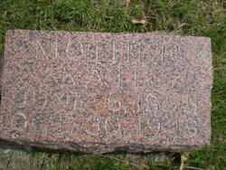
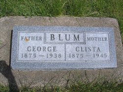
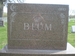
Kate Ann Kups Blum
| Birth | : | 6 Jun 1854 Czech Republic |
| Death | : | 30 Oct 1948 Linn County, Iowa, USA |
| Burial | : | Troqueer New Burial Ground, Scotland |
| Coordinate | : | 55.0399246, -3.6174200 |
| Description | : | June 1854 to October 30, 1948 Yocom Chapel Marion, Iowa Thursday, November 4, 1948 2 PM In Charge of Rev. R. E. Kerney Interment LaFayette Cemetery Lafayette, Iowa |
frequently asked questions (FAQ):
-
Where is Kate Ann Kups Blum's memorial?
Kate Ann Kups Blum's memorial is located at: Troqueer New Burial Ground, Scotland.
-
When did Kate Ann Kups Blum death?
Kate Ann Kups Blum death on 30 Oct 1948 in Linn County, Iowa, USA
-
Where are the coordinates of the Kate Ann Kups Blum's memorial?
Latitude: 55.0399246
Longitude: -3.6174200
Family Members:
Parent

Spouse

Children

Flowers:


Nearby Cemetories:
1. Troqueer New Burial Ground
Scotland
Coordinate: 55.0399246, -3.6174200
2. Troqueer Parish Churchyard
Scotland
Coordinate: 55.0398254, -3.6175921
3. Caerlaverock Parish Churchyard
Scotland
Coordinate: 55.0072220, -3.5263890
4. Irongray Churchyard
Scotland
Coordinate: 55.0986790, -3.7017490
5. Irongray Kirkyard - Extention
Scotland
Coordinate: 55.1034857, -3.7632859
6. Southwick Cemetery
Scotland
Coordinate: 54.8953040, -3.7064180
7. Buittle Cemetery
Scotland
Coordinate: 54.9195320, -3.8605370
8. Colvend Parish Churchyard
Scotland
Coordinate: 54.8683920, -3.7742470
9. Keir Churchyard
Scotland
Coordinate: 55.2198710, -3.7941310
10. Balmaghie Parish Churchyard
Scotland
Coordinate: 54.9750000, -3.9969440
11. St Paul's Churchyard
Causewayhead, Allerdale Borough, England
Coordinate: 54.8671390, -3.3552630
12. Silloth Cemetery
Silloth, Allerdale Borough, England
Coordinate: 54.8666200, -3.3551000
13. Quaker Burial Ground
Beckfoot, Copeland Borough, England
Coordinate: 54.8330850, -3.4134130
14. St Michael Churchyard
Bowness-on-Solway, Allerdale Borough, England
Coordinate: 54.9523800, -3.2135380
15. Wesleyan Home Mission Chapel Cemetery
Bowness-on-Solway, Allerdale Borough, England
Coordinate: 54.9535940, -3.2120460
16. St John's Churchyard
Newton Arlosh, Allerdale Borough, England
Coordinate: 54.8853180, -3.2506160
17. Holme St Cuthbert Churchyard
Holme St Cuthbert, Allerdale Borough, England
Coordinate: 54.8108780, -3.3951990
18. Kirkcormack Cemetery
Scotland
Coordinate: 54.8946900, -4.0027600
19. Holme Cultram Abbey Churchyard
Abbeytown, Allerdale Borough, England
Coordinate: 54.8453090, -3.2832650
20. St Bride Churchyard
Kirkbride, Allerdale Borough, England
Coordinate: 54.9047600, -3.2026500
21. Quaker Burial Ground
Allonby, Allerdale Borough, England
Coordinate: 54.7790680, -3.4296924
22. Christ Churchyard
Allonby, Allerdale Borough, England
Coordinate: 54.7671880, -3.4309950
23. St. Mungo Churchyard
Bromfield, Allerdale Borough, England
Coordinate: 54.8109800, -3.2838200
24. St Matthew’s Churchyard
Westnewton, Allerdale Borough, England
Coordinate: 54.7848970, -3.3455930