
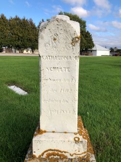

Katharinna Maria Boye Schulte
| Birth | : | 15 Dec 1802 Germany |
| Death | : | 23 Jul 1885 |
| Burial | : | Garnavillo Cemetery, Garnavillo, Clayton County, USA |
| Coordinate | : | 42.8660300, -91.2390100 |
| Description | : | On Saturday occurred the funeral of Mrs. Schulte, the mother of Henry Schulte, of Clayton township. She was in her 84th year. Her remains were followed to the grave by one of the largest funeral processions ever witnessed in this town. No less than 46 teams were in the procession. Rev. F. Sommerland preached the funeral sermon. Her funeral was July 25, 1885 Elkader Register Thursday July 30, 1885 |
frequently asked questions (FAQ):
-
Where is Katharinna Maria Boye Schulte's memorial?
Katharinna Maria Boye Schulte's memorial is located at: Garnavillo Cemetery, Garnavillo, Clayton County, USA.
-
When did Katharinna Maria Boye Schulte death?
Katharinna Maria Boye Schulte death on 23 Jul 1885 in
-
Where are the coordinates of the Katharinna Maria Boye Schulte's memorial?
Latitude: 42.8660300
Longitude: -91.2390100
Family Members:
Spouse
Children
Flowers:


Nearby Cemetories:
1. Garnavillo Cemetery
Garnavillo, Clayton County, USA
Coordinate: 42.8660300, -91.2390100
2. Garnavillo Community Cemetery
Garnavillo, Clayton County, USA
Coordinate: 42.8656000, -91.2422100
3. Saint Joseph Cemetery
Garnavillo, Clayton County, USA
Coordinate: 42.8628006, -91.2502975
4. McClelland Cemetery
Garnavillo, Clayton County, USA
Coordinate: 42.8249879, -91.2084641
5. Pioneer Rock Cemetery
Ceres, Clayton County, USA
Coordinate: 42.8230591, -91.1863937
6. Clayton Center Cemetery
Clayton Center, Clayton County, USA
Coordinate: 42.8841705, -91.3225021
7. Zion Lutheran Cemetery
Clayton Center, Clayton County, USA
Coordinate: 42.8841705, -91.3249969
8. Clayton Cemetery
Clayton, Clayton County, USA
Coordinate: 42.9043999, -91.1641998
9. Tangeman Family Cemetery
Garnavillo, Clayton County, USA
Coordinate: 42.8580000, -91.1420000
10. Saint Michael Cemetery
Clayton County, USA
Coordinate: 42.8055992, -91.1802979
11. County Home Cemetery
Clayton Center, Clayton County, USA
Coordinate: 42.8916702, -91.3499985
12. Borcherding Cemetery
Jefferson Township, Clayton County, USA
Coordinate: 42.8182983, -91.1414032
13. Krumm Cemetery
Garber, Clayton County, USA
Coordinate: 42.7913760, -91.3023559
14. Colony Catholic Cemetery (Defunct)
Read Township, Clayton County, USA
Coordinate: 42.8830000, -91.3580000
15. National Cemetery
National, Clayton County, USA
Coordinate: 42.9536018, -91.2902985
16. Harford Cemetery
Wyalusing, Grant County, USA
Coordinate: 42.9401000, -91.1401800
17. Storck Cemetery
Guttenberg, Clayton County, USA
Coordinate: 42.7694335, -91.1834638
18. Saint Paula Cemetery
Osterdock, Clayton County, USA
Coordinate: 42.7635994, -91.1992035
19. Norwegian Church Cemetery
McGregor, Clayton County, USA
Coordinate: 42.9644400, -91.1764100
20. Meenan Cemetery
Communia, Clayton County, USA
Coordinate: 42.7999862, -91.3584693
21. Old Garber Cemetery
Garber, Clayton County, USA
Coordinate: 42.7560005, -91.2580032
22. Bagley Cemetery
Bagley, Grant County, USA
Coordinate: 42.9019012, -91.0907974
23. First Evangelical Lutheran Church Cemetery
McGregor, Clayton County, USA
Coordinate: 42.9718000, -91.1760000
24. Elkader Cemetery
Elkader, Clayton County, USA
Coordinate: 42.8541718, -91.4000015