
| Birth | : | 11 May 1916 Eastport, Washington County, Maine, USA |
| Death | : | 11 Apr 1990 Okaloosa County, Florida, USA |
| Burial | : | Saint Mary's Catholic Cemetery and Mausoleum, Sacramento, Sacramento County, USA |
| Coordinate | : | 38.5298900, -121.4261200 |
| Plot | : | East Sect D #85 |
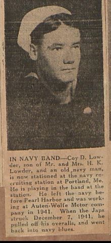
| Description | : | In the 1930 U.S. Census, John E. Brooks, 56, born N.Y., father born Wisconsin, mother born Maine, was living in Eastport, Maine, with Gurtrude J., 49, born Mass., father born N.Y., mother born Mass; Gurtrude J., 20; Elenor J., 17; M. Priscilla, 15; K. Caroline, 13; Helen E., 12; and John E. 10, all born in Maine. In the 1920 U.S. Census, John E. Brooks, 45, born N.Y., father born Illinois, mother born Maine, was living in Washington County, Maine, with Gertrude, 39, born Mass., parents born Mass.; Gertrude G., 9; Elenor J., 7; Priscilla, 6; Caroline, 4; Helen,... Read More |
frequently asked questions (FAQ):
-
Where is Katherine Carolyn Brooks Lowder's memorial?
Katherine Carolyn Brooks Lowder's memorial is located at: Saint Mary's Catholic Cemetery and Mausoleum, Sacramento, Sacramento County, USA.
-
When did Katherine Carolyn Brooks Lowder death?
Katherine Carolyn Brooks Lowder death on 11 Apr 1990 in Okaloosa County, Florida, USA
-
Where are the coordinates of the Katherine Carolyn Brooks Lowder's memorial?
Latitude: 38.5298900
Longitude: -121.4261200
Family Members:
Flowers:


Nearby Cemetories:
1. Saint Mary's Catholic Cemetery and Mausoleum
Sacramento, Sacramento County, USA
Coordinate: 38.5298900, -121.4261200
2. Sacramento County Hospital Cemetery
Sacramento, Sacramento County, USA
Coordinate: 38.5289300, -121.4239100
3. Russian Orthodox Cemetery
Sacramento, Sacramento County, USA
Coordinate: 38.5268800, -121.4244300
4. Sacramento County Cemetery
Sacramento County, USA
Coordinate: 38.5267900, -121.4233700
5. Sacramento County Veterans Memorial Cemetery
Sacramento, Sacramento County, USA
Coordinate: 38.5252838, -121.4239120
6. Tinh Xa Ngoc An Temple Columbarium
Sacramento, Sacramento County, USA
Coordinate: 38.5190200, -121.4159500
7. Sacramento Memorial Lawn Cemetery
Sacramento, Sacramento County, USA
Coordinate: 38.5146484, -121.4380341
8. Home of Peace Cemetery
Sacramento, Sacramento County, USA
Coordinate: 38.5137558, -121.4382782
9. Elder Creek Cemetery
Florin, Sacramento County, USA
Coordinate: 38.5111008, -121.4169006
10. Saint Rose Cemetery (Defunct)
Sacramento, Sacramento County, USA
Coordinate: 38.5208015, -121.4672012
11. East Lawn Memorial Park
Sacramento, Sacramento County, USA
Coordinate: 38.5612960, -121.4492760
12. Pho Minh Temple Columbarium
Sacramento, Sacramento County, USA
Coordinate: 38.5340100, -121.4769000
13. New Helvetia Cemetery (Defunct)
Sacramento, Sacramento County, USA
Coordinate: 38.5731600, -121.4639900
14. Saint Joseph Cemetery
Sacramento, Sacramento County, USA
Coordinate: 38.5574989, -121.4835968
15. Trinity Episcopal Cathedral Columbarium
Sacramento, Sacramento County, USA
Coordinate: 38.5705500, -121.4723770
16. Odd Fellows Lawn Cemetery and Mausoleum
Sacramento, Sacramento County, USA
Coordinate: 38.5585000, -121.5011000
17. Buddhist Church of Sacramento Nokotsudo
Sacramento, Sacramento County, USA
Coordinate: 38.5639300, -121.4978400
18. Sacramento City Cemetery
Sacramento, Sacramento County, USA
Coordinate: 38.5636864, -121.5009537
19. Masonic Lawn Cemetery
Sacramento, Sacramento County, USA
Coordinate: 38.5604720, -121.5032600
20. Sunset Hill Cemetery
Sacramento, Sacramento County, USA
Coordinate: 38.5608000, -121.5037300
21. California State Capitol
Sacramento, Sacramento County, USA
Coordinate: 38.5760994, -121.4931488
22. National Shrine of Our Lady of Guadalupe Crypt
Sacramento, Sacramento County, USA
Coordinate: 38.5704800, -121.5014400
23. Kim Quang Temple Columbarium
Sacramento, Sacramento County, USA
Coordinate: 38.5996600, -121.3904700
24. Holy Ascension Russian Orthodox Cemetery
Sacramento, Sacramento County, USA
Coordinate: 38.5846212, -121.4936736