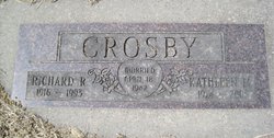
Kathleen Braley Crosby
| Birth | : | 8 Jul 1924 |
| Death | : | 27 Dec 2003 |
| Burial | : | St Nicholas Churchyard, Sturry, City of Canterbury, England |
| Coordinate | : | 51.2984830, 1.1201330 |
| Description | : | Kathleen was born on July 8, 1924 in Terry, Montana to Leon and Bessie Braley. She lived around the Miles City area where she met and married Dick Crosby on April 18, 1942. Together, they lived on their ranch on the Mizpah for several years. Dick and Kathleen moved to Owatonna, Minnesota where they lived for about 15 years before moving back to Montana. After Dick died in 1993, Kathleen moved to Helena, where she lived until her passing. Kathleen is survived by her daughter, Judy... Read More |
frequently asked questions (FAQ):
-
Where is Kathleen Braley Crosby's memorial?
Kathleen Braley Crosby's memorial is located at: St Nicholas Churchyard, Sturry, City of Canterbury, England.
-
When did Kathleen Braley Crosby death?
Kathleen Braley Crosby death on 27 Dec 2003 in
-
Where are the coordinates of the Kathleen Braley Crosby's memorial?
Latitude: 51.2984830
Longitude: 1.1201330
Family Members:
Flowers:
Nearby Cemetories:
1. St Nicholas Churchyard
Sturry, City of Canterbury, England
Coordinate: 51.2984830, 1.1201330
2. St Mary the Virgin Churchyard
Fordwich, City of Canterbury, England
Coordinate: 51.2958300, 1.1270530
3. Sturry Cemetery
Sturry, City of Canterbury, England
Coordinate: 51.3058100, 1.1277700
4. All Saints Churchyard
Westbere, City of Canterbury, England
Coordinate: 51.3065380, 1.1437670
5. St Gregory Churchyard
Canterbury, City of Canterbury, England
Coordinate: 51.2816050, 1.0887840
6. St Martin Churchyard
Canterbury, City of Canterbury, England
Coordinate: 51.2780170, 1.0937160
7. St Gregory's Priory (defunct)
Canterbury, City of Canterbury, England
Coordinate: 51.2831127, 1.0855358
8. St. John the Baptist Hospital Chapelyard
Canterbury, City of Canterbury, England
Coordinate: 51.2832713, 1.0837677
9. St Mary Northgate Cemetery
Canterbury, City of Canterbury, England
Coordinate: 51.2811320, 1.0859300
10. St Augustine Abbey Ruins
Canterbury, City of Canterbury, England
Coordinate: 51.2781280, 1.0882060
11. St Paul Without the Walls
Canterbury, City of Canterbury, England
Coordinate: 51.2779380, 1.0853180
12. Canterbury Cathedral
Canterbury, City of Canterbury, England
Coordinate: 51.2796936, 1.0826840
13. St Mary Magdalene Church Demolished
Canterbury, City of Canterbury, England
Coordinate: 51.2784510, 1.0830170
14. St George's Church Demolished
Canterbury, City of Canterbury, England
Coordinate: 51.2773770, 1.0827380
15. All Saints Church Demolished
Canterbury, City of Canterbury, England
Coordinate: 51.2802800, 1.0783450
16. St Peter the Apostle Churchyard
Canterbury, City of Canterbury, England
Coordinate: 51.2807260, 1.0775370
17. St Mary Breadman Church Demolished
Canterbury, City of Canterbury, England
Coordinate: 51.2798870, 1.0784520
18. St Margaret's Churchyard
Canterbury, City of Canterbury, England
Coordinate: 51.2781780, 1.0795840
19. St Peters Methodist Church
Canterbury, City of Canterbury, England
Coordinate: 51.2801720, 1.0771480
20. St Mary Bredin Old Church (Defunct)
Canterbury, City of Canterbury, England
Coordinate: 51.2773455, 1.0803962
21. Holy Cross Church
Canterbury, City of Canterbury, England
Coordinate: 51.2811350, 1.0755710
22. Westgate Gardens
Canterbury, City of Canterbury, England
Coordinate: 51.2805250, 1.0745040
23. Canterbury Jewish Cemetery
Canterbury, City of Canterbury, England
Coordinate: 51.2846135, 1.0706660
24. St. Dunstan Churchyard
Canterbury, City of Canterbury, England
Coordinate: 51.2836820, 1.0707800


