

Kathleen June “Kate” Hanna Drinkwalter
| Birth | : | 29 Jul 1925 Omaha, Douglas County, Nebraska, USA |
| Death | : | 22 Sep 2015 Valentine, Cherry County, Nebraska, USA |
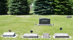
| Burial | : | Mount Hope Cemetery, Wood Lake, Cherry County, USA |
| Coordinate | : | 42.6372920, -100.2330200 |
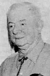
| Description | : | Funeral service for Kathleen “Kate” Drinkwalter age 90 of Valentine will be held on Friday, Sept. 25 at 2:00 PM at the Presbyterian Church in Valentine. A private family burial will be at the Mount Hope Cemetery in Wood Lake. Visitation will be on Thursday at 2:00 PM at Sandoz Chapel of the Pines in Valentine. Kathleen June Hanna was born July 23, 1925 to George P. and Myrtle (Mickelsen) Hanna in Omaha, NE. She died September 22, 2015 at Pine View Good Samaritan Home in Valentine, NE. Kate was a lifelong resident of Cherry County. She attended... Read More |
frequently asked questions (FAQ):
-
Where is Kathleen June “Kate” Hanna Drinkwalter's memorial?
Kathleen June “Kate” Hanna Drinkwalter's memorial is located at: Mount Hope Cemetery, Wood Lake, Cherry County, USA.
-
When did Kathleen June “Kate” Hanna Drinkwalter death?
Kathleen June “Kate” Hanna Drinkwalter death on 22 Sep 2015 in Valentine, Cherry County, Nebraska, USA
-
Where are the coordinates of the Kathleen June “Kate” Hanna Drinkwalter's memorial?
Latitude: 42.6372920
Longitude: -100.2330200
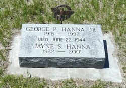
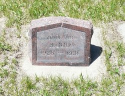
Family Members:
Parent
Spouse

Siblings

Flowers:


Nearby Cemetories:
1. Mount Hope Cemetery
Wood Lake, Cherry County, USA
Coordinate: 42.6372920, -100.2330200
2. Woodlawn Cemetery
Johnstown, Brown County, USA
Coordinate: 42.5828018, -100.0736008
3. East Woodlawn Cemetery
Johnstown, Brown County, USA
Coordinate: 42.5718994, -100.0382996
4. Grand Prairie Cemetery
Brown County, USA
Coordinate: 42.5886002, -99.9894028
5. German Cemetery
Ainsworth, Brown County, USA
Coordinate: 42.5922012, -99.9103012
6. Pleasant Dale Cemetery
Keya Paha County, USA
Coordinate: 42.8494000, -100.0608000
7. Norden Cemetery
Norden, Keya Paha County, USA
Coordinate: 42.8685837, -100.0950851
8. Norden West Cemetery
Keya Paha County, USA
Coordinate: 42.8685989, -100.0947037
9. Taylor Cemetery
Thatcher, Cherry County, USA
Coordinate: 42.8131000, -100.4832500
10. Highland Grove Cemetery
Ainsworth, Brown County, USA
Coordinate: 42.6954000, -99.8530000
11. Union Cemetery
Keya Paha County, USA
Coordinate: 42.8091780, -99.9043730
12. Ainsworth Cemetery
Ainsworth, Brown County, USA
Coordinate: 42.5341988, -99.8503036
13. Sparks Cemetery
Sparks, Cherry County, USA
Coordinate: 42.9399986, -100.2463989
14. Kewanee Cemetery
Cherry County, USA
Coordinate: 42.9332020, -100.3366500
15. Fort Niobrara Post Cemetery
Valentine, Cherry County, USA
Coordinate: 42.8885630, -100.4779260
16. East Park Cemetery
Ainsworth, Brown County, USA
Coordinate: 42.5511017, -99.8244019
17. Hartgrave Cemetery
Cherry County, USA
Coordinate: 42.3244500, -100.2680800
18. Simeon Cemetery
Cherry County, USA
Coordinate: 42.6704000, -100.6629000
19. Mount Hope Cemetery
Valentine, Cherry County, USA
Coordinate: 42.8669014, -100.5350037
20. Minnechaduza Cemetery
Valentine, Cherry County, USA
Coordinate: 42.8731003, -100.5674973
21. Saint Joseph Cemetery
Kewanee, Cherry County, USA
Coordinate: 42.9700000, -100.3373500
22. Lost Creek Cemetery
Keya Paha County, USA
Coordinate: 42.9486008, -99.9646988
23. Buffalo Flats Cemetery
Ainsworth, Brown County, USA
Coordinate: 42.5786700, -99.7357700
24. Shady Rest Cemetery
Valentine, Cherry County, USA
Coordinate: 42.4598160, -100.6837050