
| Birth | : | 25 Nov 1855 Dundenheim, Ortenaukreis, Baden-Württemberg, Germany |
| Death | : | 22 Aug 1925 Hooper, Dodge County, Nebraska, USA |
| Burial | : | Pleasington Priory, Pleasington, Blackburn with Darwen Unitary Authority, England |
| Coordinate | : | 53.7348590, -2.5433060 |
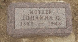
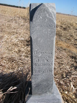
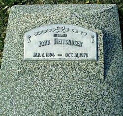
| Description | : | Mini Biography Kathrine Roth Heitshusen, 69, was born on November 25, 1855 in Germany. She married John G. Heitshusen at Homestead, IA, and they lived in the Sommerville area of Dodge County, NE for about 20 years. Kathrine died on August 22, 1925 and is buried at St. John's cemetery, Hooper, Nebraska. They had 10 children: 1. Anna Marie S. 6-2-1883 > 3-16-1941 Res-Santa Anna, CA (m * Hermann D. Heineman 3-19-1879 > 1-2-1960 Res-Anaheim, CA) 2. Maria W. (Minnie) 11-28-1884 > 11-25-1969 Buried-Hooper (m 1904 Herman Suhr 12-19-1878 > 8-25-1955 Buried-Hooper) 3. Emma M. S. 11-10-1886... Read More |
frequently asked questions (FAQ):
-
Where is Kathrine Roth Heitshusen's memorial?
Kathrine Roth Heitshusen's memorial is located at: Pleasington Priory, Pleasington, Blackburn with Darwen Unitary Authority, England.
-
When did Kathrine Roth Heitshusen death?
Kathrine Roth Heitshusen death on 22 Aug 1925 in Hooper, Dodge County, Nebraska, USA
-
Where are the coordinates of the Kathrine Roth Heitshusen's memorial?
Latitude: 53.7348590
Longitude: -2.5433060
Family Members:
Parent
Spouse

Siblings
Children
Flowers:


Nearby Cemetories:
1. Pleasington Priory
Pleasington, Blackburn with Darwen Unitary Authority, England
Coordinate: 53.7348590, -2.5433060
2. Pleasington Cemetery and Crematorium
Blackburn, Blackburn with Darwen Unitary Authority, England
Coordinate: 53.7388880, -2.5368710
3. Holy Trinity Churchyard
Hoghton, Chorley Borough, England
Coordinate: 53.7279300, -2.5848550
4. St. Josephs Roman Catholic Churchyard
Brindle, Chorley Borough, England
Coordinate: 53.7350780, -2.5880640
5. New Row Methodist Church
Blackburn with Darwen Unitary Authority, England
Coordinate: 53.7208950, -2.5023720
6. St Stephen Churchyard
Tockholes, Blackburn with Darwen Unitary Authority, England
Coordinate: 53.7058350, -2.5169320
7. St. Peter's Churchyard
Blackburn, Blackburn with Darwen Unitary Authority, England
Coordinate: 53.7448110, -2.4865070
8. St Paul's
Blackburn, Blackburn with Darwen Unitary Authority, England
Coordinate: 53.7491222, -2.4891266
9. Independent Chapel Churchyard
Blackburn, Blackburn with Darwen Unitary Authority, England
Coordinate: 53.7454960, -2.4864460
10. Wesleyan Methodist Chapel Chapelyard
Blackburn, Blackburn with Darwen Unitary Authority, England
Coordinate: 53.7464910, -2.4848380
11. Blackburn Cathedral
Blackburn, Blackburn with Darwen Unitary Authority, England
Coordinate: 53.7472960, -2.4820020
12. St. Mary's Churchyard
Mellor, Ribble Valley Borough, England
Coordinate: 53.7728600, -2.5312400
13. St Paul's Churchyard
Withnell, Chorley Borough, England
Coordinate: 53.6970740, -2.5592150
14. Mellor Methodist Churchyard
Blackburn, Blackburn with Darwen Unitary Authority, England
Coordinate: 53.7742950, -2.5255060
15. Mount St Presbyterian Chapelyard
Blackburn, Blackburn with Darwen Unitary Authority, England
Coordinate: 53.7478000, -2.4775000
16. Holy Trinity Church
Blackburn with Darwen Unitary Authority, England
Coordinate: 53.7511727, -2.4747178
17. St James's Churchyard
Brindle, Chorley Borough, England
Coordinate: 53.7133333, -2.6086111
18. St Alban's Churchyard
Blackburn, Blackburn with Darwen Unitary Authority, England
Coordinate: 53.7530090, -2.4748540
19. St Mary's R.C. Church Cemetery
Osbaldeston, Ribble Valley Borough, England
Coordinate: 53.7816970, -2.5350240
20. St James Churchyard
Lower Darwen, Blackburn with Darwen Unitary Authority, England
Coordinate: 53.7245510, -2.4634700
21. St Leonard Churchyard
Balderstone, Ribble Valley Borough, England
Coordinate: 53.7860070, -2.5609380
22. Blackburn Cemetery
Blackburn, Blackburn with Darwen Unitary Authority, England
Coordinate: 53.7662430, -2.4726050
23. St. Mary's and St. John RC Churchyard, Southworth
Samlesbury, South Ribble Borough, England
Coordinate: 53.7676690, -2.6183400
24. St. Leonard the Less Churchyard
Samlesbury, South Ribble Borough, England
Coordinate: 53.7680000, -2.6237000