
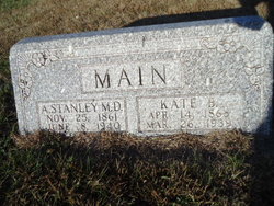
Kayte Belle “Kate” Moon Main
| Birth | : | 14 Apr 1868 Forestville, Delaware County, Iowa, USA |
| Death | : | 26 Mar 1939 Loup City, Sherman County, Nebraska, USA |
| Burial | : | Evergreen Cemetery, Loup City, Sherman County, USA |
| Coordinate | : | 41.2997017, -98.9852982 |
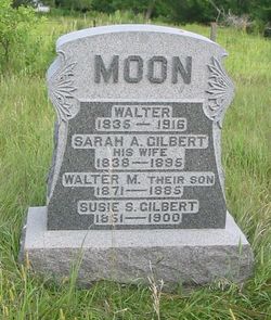
| Description | : | Married Mar 7 1901 Loup City, Sherman, NE, Dr Amos Stanley Main No children ---------------------------------------------- Funeral Rites For Mrs. A. S. Main Held Wednesday Afternoon Died At Home Sunday Evening; Burial In Evergreen Cemetery. Funeral services for Mrs. A. S. Main were held at the Baptist church Wednesday afternoon in charge of Rev. M. H. Knobloch and burial was made in the Evergreen cemetery. Mrs. Main died at 9:15 Sunday evening, March 26. On January 22 she fell in her home suffering a severe injury and after nine weeks of suffering, death occurred. Kate B. Moon, daughter of Walter and Sarah Moon was born at Forestville, Iowa,... Read More |
frequently asked questions (FAQ):
-
Where is Kayte Belle “Kate” Moon Main's memorial?
Kayte Belle “Kate” Moon Main's memorial is located at: Evergreen Cemetery, Loup City, Sherman County, USA.
-
When did Kayte Belle “Kate” Moon Main death?
Kayte Belle “Kate” Moon Main death on 26 Mar 1939 in Loup City, Sherman County, Nebraska, USA
-
Where are the coordinates of the Kayte Belle “Kate” Moon Main's memorial?
Latitude: 41.2997017
Longitude: -98.9852982
Family Members:
Parent

Spouse

Siblings


Flowers:


Nearby Cemetories:
1. Evergreen Cemetery
Loup City, Sherman County, USA
Coordinate: 41.2997017, -98.9852982
2. Saint Josaphats Cemetery
Loup City, Sherman County, USA
Coordinate: 41.3022003, -98.9847031
3. Sunny Slope Cemetery
Loup City, Sherman County, USA
Coordinate: 41.2906000, -99.0267000
4. Cleoria Cemetery
Loup City, Sherman County, USA
Coordinate: 41.2779000, -99.0893500
5. Balsora Cemetery
Sherman County, USA
Coordinate: 41.3782997, -99.0975037
6. Austin Cemetery
Rockville, Sherman County, USA
Coordinate: 41.1880989, -98.8981018
7. Verdurette Cemetery
Sherman County, USA
Coordinate: 41.1697006, -98.9757996
8. Davis Creek Cemetery
Valley County, USA
Coordinate: 41.4219017, -98.9052963
9. Saint Francis Cemetery
Ashton, Sherman County, USA
Coordinate: 41.2438000, -98.7994000
10. Lone Elm Cemetery
Loup City, Sherman County, USA
Coordinate: 41.2921982, -99.1864014
11. Immanuel Lutheran Cemetery
Ashton, Sherman County, USA
Coordinate: 41.2140000, -98.8142000
12. Gray Cemetery
Sherman County, USA
Coordinate: 41.2099991, -99.1567001
13. Arcadia Cemetery
Arcadia, Valley County, USA
Coordinate: 41.4237000, -99.1167000
14. Pleasant Hill Friends Cemetery
Valley County, USA
Coordinate: 41.4230800, -98.8377700
15. Dunkard Cemetery
Arcadia, Valley County, USA
Coordinate: 41.4522000, -99.0769000
16. Union Cemetery
Ashton, Sherman County, USA
Coordinate: 41.2214012, -98.7855988
17. Litchfield Cemetery
Litchfield, Sherman County, USA
Coordinate: 41.1543999, -99.1283035
18. Mount Carmel Cemetery
Howard County, USA
Coordinate: 41.2797012, -98.7328033
19. Salem Evangelical Church Cemetery
Ord, Valley County, USA
Coordinate: 41.4902992, -98.9244003
20. Lewis Burial Plat
Litchfield, Sherman County, USA
Coordinate: 41.1383000, -99.1484000
21. Trinity Lutheran Church Cemetery
Hazard, Sherman County, USA
Coordinate: 41.0913000, -99.0052000
22. Lee Park Cemetery
Custer County, USA
Coordinate: 41.4025002, -99.2307968
23. Lee Park Catholic Cemetery
Westerville, Custer County, USA
Coordinate: 41.4091988, -99.2311020
24. Saint Marys Cemetery
Rockville, Sherman County, USA
Coordinate: 41.1202000, -98.8255000