
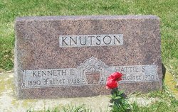
Kenneth Elias Knutson
| Birth | : | 17 Aug 1890 Dolliver, Emmet County, Iowa, USA |
| Death | : | 2 Jun 1938 Des Moines, Polk County, Iowa, USA |
| Burial | : | Palestine Cemetery, Dolliver, Emmet County, USA |
| Coordinate | : | 43.4880000, -94.6408000 |
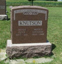
| Description | : | Knutson Obituary Kenneth Elias Knutson, the son of Mr. and Mrs. Peter Knutson, was born near Dolliver, Iowa on August 17, 1890. From the weakened condition of his heart he passed away in Des Moines, Iowa on June 2, 1938. At his death he was 47 years, 9 months and 16 days old. He spent his boyhood days on his father's farm where he also attended the rural public schools. On April 16, 1905 in the Palestine church he was confirmed in the Lutheran faith after having received religious instruction in the parental home, in the Sunday school and under the ministry... Read More |
frequently asked questions (FAQ):
-
Where is Kenneth Elias Knutson's memorial?
Kenneth Elias Knutson's memorial is located at: Palestine Cemetery, Dolliver, Emmet County, USA.
-
When did Kenneth Elias Knutson death?
Kenneth Elias Knutson death on 2 Jun 1938 in Des Moines, Polk County, Iowa, USA
-
Where are the coordinates of the Kenneth Elias Knutson's memorial?
Latitude: 43.4880000
Longitude: -94.6408000
Family Members:
Parent

Spouse
Siblings
Flowers:


Nearby Cemetories:
1. Palestine Cemetery
Dolliver, Emmet County, USA
Coordinate: 43.4880000, -94.6408000
2. Lincoln Township Cemetery
Dolliver, Emmet County, USA
Coordinate: 43.4441986, -94.6204987
3. Lake Belt Cemetery
Ceylon, Martin County, USA
Coordinate: 43.5353012, -94.6742020
4. Tenhassen Cemetery
Ceylon, Martin County, USA
Coordinate: 43.5293999, -94.5877991
5. Ellsworth Cemetery
Emmet County, USA
Coordinate: 43.5005989, -94.7249985
6. German Evangelical Cemetery
Wilbert, Martin County, USA
Coordinate: 43.5325600, -94.5419000
7. Saint Pauls Lutheran Church Cemetery
Wilbert, Martin County, USA
Coordinate: 43.5444500, -94.5395800
8. Swan Lake Township Cemetery
Maple Hill, Emmet County, USA
Coordinate: 43.3850746, -94.6381378
9. Prosser Cemetery
Estherville, Emmet County, USA
Coordinate: 43.4422000, -94.7783000
10. Lake Fremont Cemetery
Dunnell, Martin County, USA
Coordinate: 43.5691986, -94.7746964
11. Center Township Cemetery
Emmet County, USA
Coordinate: 43.3608000, -94.6790000
12. Armstrong Grove Cemetery
Armstrong, Emmet County, USA
Coordinate: 43.3985696, -94.5041425
13. Saint Marys Catholic Cemetery
Armstrong, Emmet County, USA
Coordinate: 43.3980000, -94.5048000
14. Lone Cedar Cemetery
Sherburn, Martin County, USA
Coordinate: 43.6166992, -94.7144012
15. Mount Calvary Cemetery
Armstrong, Emmet County, USA
Coordinate: 43.3850000, -94.5028000
16. Center Chain Cemetery
Martin County, USA
Coordinate: 43.5224991, -94.4483032
17. Estherville Lutheran Cemetery
Estherville, Emmet County, USA
Coordinate: 43.4298000, -94.8263000
18. Norwegian Cemetery
Estherville, Emmet County, USA
Coordinate: 43.4291992, -94.8261032
19. East Side Memorial Cemetery
Estherville, Emmet County, USA
Coordinate: 43.4267750, -94.8265600
20. East Side Cemetery
Estherville, Emmet County, USA
Coordinate: 43.4068985, -94.8264008
21. Sherburn Cemetery
Sherburn, Martin County, USA
Coordinate: 43.6455612, -94.7275009
22. Saint Patricks Cemetery
Estherville, Emmet County, USA
Coordinate: 43.3843994, -94.8283005
23. Saint Lukes Cemetery
Sherburn, Martin County, USA
Coordinate: 43.6530120, -94.7133132
24. Oak Hill Cemetery
Estherville, Emmet County, USA
Coordinate: 43.3986015, -94.8518982