
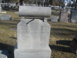
LaFayette Elliot Pease
| Birth | : | 21 Oct 1858 Illinois, USA |
| Death | : | 5 Jan 1910 North Platte, Lincoln County, Nebraska, USA |
| Burial | : | Desert Lawn Memorial Park, Palmdale, Los Angeles County, USA |
| Coordinate | : | 34.5525890, -118.0900880 |
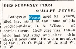
| Description | : | Buried Jan 7,1910 Lot 952 Space- 7 LaFayette Pease Oct 21,1858-Jan 5,1910 Lafayette Pease, son of S.P. Pease, and brother of Mrs. B.A.Wilson, died at the home the of the latter early yesterday morning after an illness of but a few days. The deceased came here several years ago from Myrtle precinct and was employed at the stockyards, and later at the brick barn on Front Street. Mr. Pease was about fifty years of age. The North Platte semi-weekly tribune., January 07, 1910 |
frequently asked questions (FAQ):
-
Where is LaFayette Elliot Pease's memorial?
LaFayette Elliot Pease's memorial is located at: Desert Lawn Memorial Park, Palmdale, Los Angeles County, USA.
-
When did LaFayette Elliot Pease death?
LaFayette Elliot Pease death on 5 Jan 1910 in North Platte, Lincoln County, Nebraska, USA
-
Where are the coordinates of the LaFayette Elliot Pease's memorial?
Latitude: 34.5525890
Longitude: -118.0900880
Family Members:
Parent
Siblings
Flowers:


Nearby Cemetories:
1. Desert Lawn Memorial Park
Palmdale, Los Angeles County, USA
Coordinate: 34.5525890, -118.0900880
2. Palmdale Cemetery
Palmdale, Los Angeles County, USA
Coordinate: 34.5592003, -118.0916977
3. Acton Community Cemetery
Acton, Los Angeles County, USA
Coordinate: 34.4791985, -118.2007980
4. Mount Gleason Ranch Cemetery
Acton, Los Angeles County, USA
Coordinate: 34.4410480, -118.1980720
5. Joshua Memorial Park
Lancaster, Los Angeles County, USA
Coordinate: 34.6958008, -118.1141968
6. Lancaster Cemetery
Lancaster, Los Angeles County, USA
Coordinate: 34.6977806, -118.1286087
7. Good Shepherd Catholic Cemetery
Lancaster, Los Angeles County, USA
Coordinate: 34.6656400, -118.2541300
8. Vasquez Rocks Natural Area County Park Burial Site
Agua Dulce, Los Angeles County, USA
Coordinate: 34.4886600, -118.3214500
9. Loomis Family Cemetery
Mount Wilson, Los Angeles County, USA
Coordinate: 34.3470200, -118.0488700
10. Saint Andrews Abbey Cemetery
Valyermo, Los Angeles County, USA
Coordinate: 34.4521217, -117.8681335
11. Llano Del Rio Cemetery
Llano, Los Angeles County, USA
Coordinate: 34.4851000, -117.8092100
12. Colby Ranch Cemetery
Palmdale, Los Angeles County, USA
Coordinate: 34.2986200, -118.1115100
13. Mitchell-Dyer Family Cemetery
Santa Clarita, Los Angeles County, USA
Coordinate: 34.4210200, -118.4309600
14. Sand Canyon Ranch Burial Site
Santa Clarita, Los Angeles County, USA
Coordinate: 34.3766880, -118.4105940
15. Verdugo Hills Cemetery
Tujunga, Los Angeles County, USA
Coordinate: 34.2619019, -118.2822037
16. Glen Haven Memorial Park
Sylmar, Los Angeles County, USA
Coordinate: 34.3085130, -118.3768380
17. Brown Mountain Grave Site
Altadena, Los Angeles County, USA
Coordinate: 34.2161400, -118.1612160
18. Sholom Memorial Park
Sylmar, Los Angeles County, USA
Coordinate: 34.3051630, -118.3763500
19. Islamic Cemetery and Masjid
Rosamond, Kern County, USA
Coordinate: 34.8385340, -118.3402240
20. Saint Georges Church Peace Garden
La Cañada Flintridge, Los Angeles County, USA
Coordinate: 34.2021700, -118.1960800
21. Mountain View Cemetery and Mausoleum
Altadena, Los Angeles County, USA
Coordinate: 34.1861000, -118.1481018
22. Pioneer Memorial Cemetery
Sylmar, Los Angeles County, USA
Coordinate: 34.3209305, -118.4481125
23. Ruiz-Perea Family Cemetery
Santa Clarita, Los Angeles County, USA
Coordinate: 34.4889170, -118.5458940
24. Mater Dolorosa Passionist Retreat Center Cemetery
Sierra Madre, Los Angeles County, USA
Coordinate: 34.1709633, -118.0647049