
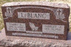
Larry Lee LeBlanc
| Birth | : | 6 Apr 1938 Clyde, Cloud County, Kansas, USA |
| Death | : | 20 Oct 1983 Concordia, Cloud County, Kansas, USA |
| Burial | : | Saint Joseph Cemetery, Saint Joseph, Cloud County, USA |
| Coordinate | : | 39.5074941, -97.4022328 |
| Inscription | : | Married Shirley, Oct. 21, 1961 Parents of Julie, Kevin and Kenton |
| Description | : | Salina Journal - October 22, 1983 Larry LeBlanc CLYDE — Larry L. LeBlanc, 45, Clyde, died Thursday night at St. Joseph's Hospital, Concordia. He was born April 6, 1938, in Clyde, and was a lifetime resident of Cloud County. Mr. LeBlanc was a farmer and a member of the Catholic Church. He served three years in the U.S. Army in Germany and was a member of the American Legion, the Veterans of Foreign Wars, the Moose, the Elks and the Knights of Columbus. Mr. LeBlanc attended grade school in Como, south of Clyde, and went to high school in Clyde. |
frequently asked questions (FAQ):
-
Where is Larry Lee LeBlanc's memorial?
Larry Lee LeBlanc's memorial is located at: Saint Joseph Cemetery, Saint Joseph, Cloud County, USA.
-
When did Larry Lee LeBlanc death?
Larry Lee LeBlanc death on 20 Oct 1983 in Concordia, Cloud County, Kansas, USA
-
Where are the coordinates of the Larry Lee LeBlanc's memorial?
Latitude: 39.5074941
Longitude: -97.4022328
Family Members:
Parent

Spouse

Siblings
Flowers:


Nearby Cemetories:
1. Saint Joseph Cemetery
Saint Joseph, Cloud County, USA
Coordinate: 39.5074941, -97.4022328
2. Pleasant View Cemetery
Ames, Cloud County, USA
Coordinate: 39.5346985, -97.4431000
3. Cedar Grove Cemetery
Clyde, Cloud County, USA
Coordinate: 39.5494003, -97.4056015
4. Iwacura Cemetery
Morganville, Clay County, USA
Coordinate: 39.4550000, -97.3510000
5. French Presbyterian Church Cemetery
Cloud County, USA
Coordinate: 39.4395200, -97.4148290
6. Green Mound Cemetery
Rice, Cloud County, USA
Coordinate: 39.5248450, -97.5081630
7. Riverdale Cemetery
Clay County, USA
Coordinate: 39.5106010, -97.2930984
8. Mount Calvary Cemetery
Clyde, Cloud County, USA
Coordinate: 39.5917015, -97.4143982
9. Princeville Cemetery
Aurora, Cloud County, USA
Coordinate: 39.4672012, -97.5010986
10. Mount Hope Cemetery
Clyde, Cloud County, USA
Coordinate: 39.5969009, -97.4116974
11. Saint Peters Cemetery
Aurora, Cloud County, USA
Coordinate: 39.4763985, -97.5180969
12. Walnut Grove Cemetery
Cloud County, USA
Coordinate: 39.5699997, -97.4993973
13. Nelson Cemetery
Rice, Cloud County, USA
Coordinate: 39.5257988, -97.5410995
14. Bloom Cemetery
Morganville, Clay County, USA
Coordinate: 39.4519005, -97.2778015
15. Lincoln Cemetery
Clay Center, Clay County, USA
Coordinate: 39.4230995, -97.2930984
16. Sulphur Springs Cemetery
Aurora, Cloud County, USA
Coordinate: 39.4086610, -97.4986840
17. Rice Cemetery
Rice, Cloud County, USA
Coordinate: 39.5614014, -97.5552979
18. Sherman Cemetery
Morganville, Clay County, USA
Coordinate: 39.5316300, -97.2243700
19. Smith Grave
Miltonvale, Cloud County, USA
Coordinate: 39.3645300, -97.4308700
20. Hollis Cemetery
Cloud County, USA
Coordinate: 39.6383018, -97.5361023
21. Norwegian Lutheran Cemetery
Clay Center, Clay County, USA
Coordinate: 39.5027900, -97.1828200
22. Agenda Cemetery
Agenda, Republic County, USA
Coordinate: 39.6761017, -97.4336014
23. Morganville City Cemetery
Morganville, Clay County, USA
Coordinate: 39.4733009, -97.1819000
24. Miltonvale Cemetery
Miltonvale, Cloud County, USA
Coordinate: 39.3358002, -97.4447021