
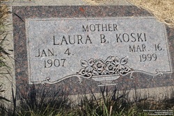

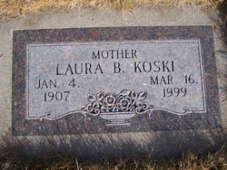

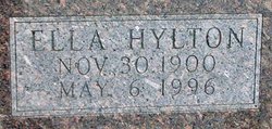
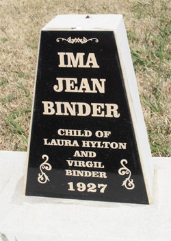
Laura Hylton Koski
| Birth | : | 4 Jan 1907 Council Grove, Morris County, Kansas, USA |
| Death | : | 16 Mar 1999 Spearfish, Lawrence County, South Dakota, USA |
| Burial | : | Mountain Lawn Cemetery, Englewood, Lawrence County, USA |
| Coordinate | : | 44.2818985, -103.8047028 |
| Plot | : | Section 9 Lot 33 grave 3 |
| Description | : | Funeral Services for Laura Koski, 92, of Lead, will be at 2 p.m. on Monday March 22, 1999 at the Chaput Memorial Chapel in Lead. The Rev. Harold Brink will officate. Laura died Tuesday, March 16, 1999 at Lookout Memorial in Spearfish. A memorial has been established. Visitation will be on Sunday, March 21, 1999 from 12 noon until 4 p.m and on Monday, March 22, 1999 from 10 a.m. until service time at the Chaput Memorial Chapel in Lead. Burial will be at the Mountain Lawn Cemetery in Lead. Laura was born on January 4, 1907 at Council Grove, Kansas to Harden... Read More |
frequently asked questions (FAQ):
-
Where is Laura Hylton Koski's memorial?
Laura Hylton Koski's memorial is located at: Mountain Lawn Cemetery, Englewood, Lawrence County, USA.
-
When did Laura Hylton Koski death?
Laura Hylton Koski death on 16 Mar 1999 in Spearfish, Lawrence County, South Dakota, USA
-
Where are the coordinates of the Laura Hylton Koski's memorial?
Latitude: 44.2818985
Longitude: -103.8047028
Family Members:
Parent

Spouse
Siblings
Children
Flowers:


Nearby Cemetories:
1. Holy Cross Cemetery
Englewood, Lawrence County, USA
Coordinate: 44.2818985, -103.8047028
2. Mountain Lawn Cemetery
Englewood, Lawrence County, USA
Coordinate: 44.2818985, -103.8047028
3. Terry Cemetery
Terry, Lawrence County, USA
Coordinate: 44.3344290, -103.8165110
4. Dumont Cemetery
Lawrence County, USA
Coordinate: 44.2270000, -103.7860000
5. Carr Cemetery
Hanna, Lawrence County, USA
Coordinate: 44.2411003, -103.8606033
6. West Lead Cemetery
Lead, Lawrence County, USA
Coordinate: 44.3484001, -103.7779999
7. South Lead Cemetery
Lead, Lawrence County, USA
Coordinate: 44.3478510, -103.7606260
8. Preston Ghost Town Cemetery
Preston, Lawrence County, USA
Coordinate: 44.3577500, -103.8871670
9. Roubaix Cemetery
Roubaix, Lawrence County, USA
Coordinate: 44.2789380, -103.6656600
10. Mount Moriah Cemetery
Deadwood, Lawrence County, USA
Coordinate: 44.3760986, -103.7253036
11. Saint Ambrose Cemetery
Deadwood, Lawrence County, USA
Coordinate: 44.3821983, -103.7266998
12. Carbonate Cemetery
Maurice, Lawrence County, USA
Coordinate: 44.4000000, -103.8680500
13. Galena Cemetery
Galena, Lawrence County, USA
Coordinate: 44.3349220, -103.6438410
14. Mountain Meadow Cemetery
Lawrence County, USA
Coordinate: 44.2038994, -103.6557999
15. Oak Ridge Cemetery
Deadwood, Lawrence County, USA
Coordinate: 44.3891983, -103.6766968
16. Bell Park Cemetery
Rochford, Pennington County, USA
Coordinate: 44.1116982, -103.7466965
17. Bear Gulch Cemetery
Lawrence County, USA
Coordinate: 44.3819008, -104.0325012
18. Reynolds Ranch Cemetery
Rochford, Pennington County, USA
Coordinate: 44.0875667, -103.8027265
19. Rose Hill Cemetery
Spearfish, Lawrence County, USA
Coordinate: 44.4802180, -103.8509270
20. Crook City Cemetery
Crook City, Lawrence County, USA
Coordinate: 44.4432100, -103.6241500
21. Anderson Cemetery
Lawrence County, USA
Coordinate: 44.4747009, -103.6896973
22. Whitewood Cemetery
Whitewood, Lawrence County, USA
Coordinate: 44.4617820, -103.6330030
23. Nemo Cemetery
Nemo, Lawrence County, USA
Coordinate: 44.1872800, -103.5066410
24. Saint Aloysius Cemetery
Sturgis, Meade County, USA
Coordinate: 44.4141340, -103.5193420