
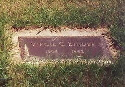
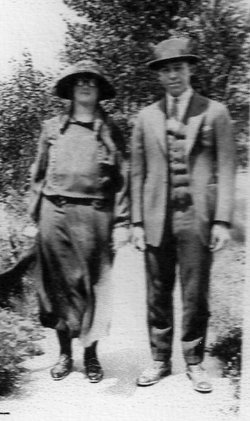
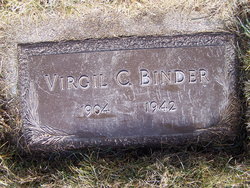
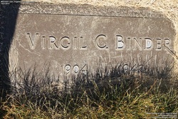
Virgil Charles Binder
| Birth | : | 29 Feb 1904 Waterville, Marshall County, Kansas, USA |
| Death | : | 4 Apr 1942 Lead, Lawrence County, South Dakota, USA |
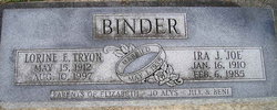
| Burial | : | Mountain Lawn Cemetery, Englewood, Lawrence County, USA |
| Coordinate | : | 44.2818985, -103.8047028 |
| Plot | : | Section 9 Lot 33 Grave 1 |
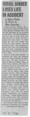
| Description | : | Mountain Lawn Cemetery Records, City of Lead: Age: 38 years 1 month 5 days Social Status: Married Cause of death: Crushing injury, falling rock in mine Next of Kin: Mrs. Virgil Binder Lead Daily Call, Monday, April 6, 1942, page 1: VIRGIL BINDER LOSES LIFE IN ACCIDENT Is Killed While At Work In Mine Saturday Virgil Charles Binder, 38, a miner in the employ of the Homestake Mining company here, lost his life Saturday in an accident in the mine. He was working on top of a pile of loose rock,... Read More |
frequently asked questions (FAQ):
-
Where is Virgil Charles Binder's memorial?
Virgil Charles Binder's memorial is located at: Mountain Lawn Cemetery, Englewood, Lawrence County, USA.
-
When did Virgil Charles Binder death?
Virgil Charles Binder death on 4 Apr 1942 in Lead, Lawrence County, South Dakota, USA
-
Where are the coordinates of the Virgil Charles Binder's memorial?
Latitude: 44.2818985
Longitude: -103.8047028
Family Members:
Parent
Spouse
Siblings
Children

Flowers:


Nearby Cemetories:
1. Holy Cross Cemetery
Englewood, Lawrence County, USA
Coordinate: 44.2818985, -103.8047028
2. Mountain Lawn Cemetery
Englewood, Lawrence County, USA
Coordinate: 44.2818985, -103.8047028
3. Terry Cemetery
Terry, Lawrence County, USA
Coordinate: 44.3344290, -103.8165110
4. Dumont Cemetery
Lawrence County, USA
Coordinate: 44.2270000, -103.7860000
5. Carr Cemetery
Hanna, Lawrence County, USA
Coordinate: 44.2411003, -103.8606033
6. West Lead Cemetery
Lead, Lawrence County, USA
Coordinate: 44.3484001, -103.7779999
7. South Lead Cemetery
Lead, Lawrence County, USA
Coordinate: 44.3478510, -103.7606260
8. Preston Ghost Town Cemetery
Preston, Lawrence County, USA
Coordinate: 44.3577500, -103.8871670
9. Roubaix Cemetery
Roubaix, Lawrence County, USA
Coordinate: 44.2789380, -103.6656600
10. Mount Moriah Cemetery
Deadwood, Lawrence County, USA
Coordinate: 44.3760986, -103.7253036
11. Saint Ambrose Cemetery
Deadwood, Lawrence County, USA
Coordinate: 44.3821983, -103.7266998
12. Carbonate Cemetery
Maurice, Lawrence County, USA
Coordinate: 44.4000000, -103.8680500
13. Galena Cemetery
Galena, Lawrence County, USA
Coordinate: 44.3349220, -103.6438410
14. Mountain Meadow Cemetery
Lawrence County, USA
Coordinate: 44.2038994, -103.6557999
15. Oak Ridge Cemetery
Deadwood, Lawrence County, USA
Coordinate: 44.3891983, -103.6766968
16. Bell Park Cemetery
Rochford, Pennington County, USA
Coordinate: 44.1116982, -103.7466965
17. Bear Gulch Cemetery
Lawrence County, USA
Coordinate: 44.3819008, -104.0325012
18. Reynolds Ranch Cemetery
Rochford, Pennington County, USA
Coordinate: 44.0875667, -103.8027265
19. Rose Hill Cemetery
Spearfish, Lawrence County, USA
Coordinate: 44.4802180, -103.8509270
20. Crook City Cemetery
Crook City, Lawrence County, USA
Coordinate: 44.4432100, -103.6241500
21. Anderson Cemetery
Lawrence County, USA
Coordinate: 44.4747009, -103.6896973
22. Whitewood Cemetery
Whitewood, Lawrence County, USA
Coordinate: 44.4617820, -103.6330030
23. Nemo Cemetery
Nemo, Lawrence County, USA
Coordinate: 44.1872800, -103.5066410
24. Saint Aloysius Cemetery
Sturgis, Meade County, USA
Coordinate: 44.4141340, -103.5193420