
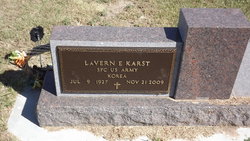

LaVern Elton “PeeWee” Karst
| Birth | : | 9 Jul 1927 Galatia, Barton County, Kansas, USA |
| Death | : | 21 Nov 2009 Great Bend, Barton County, Kansas, USA |
| Burial | : | Saint Pauls Churchyard, Brightwater, Tasman District, New Zealand |
| Coordinate | : | -41.3705220, 173.1032750 |
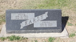
| Description | : | HOISINGTON — LaVern E. "PeeWee" Karst, 82, died Nov. 21 at Central Kansas Medical Center in Great Bend. Born July 9, 1927, in rural Galatia, he was the son of Georg Peter Karst and Freda (Schwartzkopf) Karst. On Dec. 27, 1952, he married Joyce Eurich in Milberger. She survives. A lifetime resident of Barton county and a Hoisington resident since 1955, he was the retired owner of Karst Construction Company of Hoisington. Mr. Karst was a United States Army veteran of the Korean Conflict. He was a member of the United Emmanuel Lutheran Church in Milberger, a life member of the... Read More |
frequently asked questions (FAQ):
-
Where is LaVern Elton “PeeWee” Karst's memorial?
LaVern Elton “PeeWee” Karst's memorial is located at: Saint Pauls Churchyard, Brightwater, Tasman District, New Zealand.
-
When did LaVern Elton “PeeWee” Karst death?
LaVern Elton “PeeWee” Karst death on 21 Nov 2009 in Great Bend, Barton County, Kansas, USA
-
Where are the coordinates of the LaVern Elton “PeeWee” Karst's memorial?
Latitude: -41.3705220
Longitude: 173.1032750
Family Members:
Parent

Siblings

Children

Flowers:


Nearby Cemetories:
1. Saint Pauls Churchyard
Brightwater, Tasman District, New Zealand
Coordinate: -41.3705220, 173.1032750
2. Spring Grove School Burials
Spring Grove, Tasman District, New Zealand
Coordinate: -41.3852900, 173.0903000
3. Hope Gardens of Remembrance and Crematorium
Hope, Tasman District, New Zealand
Coordinate: -41.3781226, 173.1329303
4. St Michael's Churchyard
Brightwater, Tasman District, New Zealand
Coordinate: -41.3383330, 173.1060180
5. Waimea West Cemetery
Brightwater, Tasman District, New Zealand
Coordinate: -41.3364880, 173.1062950
6. Spring Grove Cemetery
Wakefield, Tasman District, New Zealand
Coordinate: -41.4013610, 173.0822780
7. St John's Lutheran Churchyard
Hope, Tasman District, New Zealand
Coordinate: -41.3496940, 173.1488400
8. Pioneer Family Grave
Hope, Tasman District, New Zealand
Coordinate: -41.3589679, 173.1671130
9. Busch Graves
Hope, Tasman District, New Zealand
Coordinate: -41.4048597, 173.1533852
10. Saint Joseph's Church Cemetery
Wakefield, Tasman District, New Zealand
Coordinate: -41.4053900, 173.0506100
11. Saint Peter & Paul Catholic Churchyard
Appleby, Tasman District, New Zealand
Coordinate: -41.3172800, 173.1117800
12. Saint Johns Churchyard
Wakefield, Tasman District, New Zealand
Coordinate: -41.4101250, 173.0479030
13. Saint Alban's Appleby Churchyard
Appleby, Tasman District, New Zealand
Coordinate: -41.3173900, 173.1370900
14. Richmond Cemetery
Richmond, Tasman District, New Zealand
Coordinate: -41.3485780, 173.1782300
15. St. Mary's Orphanage Cemetery
Nelson City, New Zealand
Coordinate: -41.3302150, 173.2449810
16. Seaview Cemetery
Nelson, Nelson City, New Zealand
Coordinate: -41.3037350, 173.2262930
17. St Barnabas Anglican Churchyard
Stoke, Nelson City, New Zealand
Coordinate: -41.3126340, 173.2351600
18. Marsden Cemetery
Nelson, Nelson City, New Zealand
Coordinate: -41.3178960, 173.2488480
19. St. Paul's Lutheran Churchyard
Upper Moutere, Tasman District, New Zealand
Coordinate: -41.2703770, 173.0058870
20. Foxhill Cemetery
Foxhill, Tasman District, New Zealand
Coordinate: -41.4421470, 172.9618070
21. Moutere Hills Cemetery
Upper Moutere, Tasman District, New Zealand
Coordinate: -41.2365927, 173.0102027
22. Haven Cemetery
Nelson, Nelson City, New Zealand
Coordinate: -41.2732100, 173.2603300
23. Haulashore Island
Nelson, Nelson City, New Zealand
Coordinate: -41.2691290, 173.2589020
24. Fairfield Cemetery
Nelson, Nelson City, New Zealand
Coordinate: -41.2827760, 173.2832300