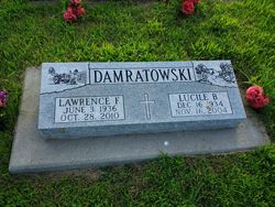
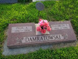
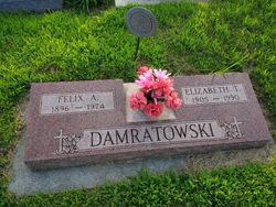
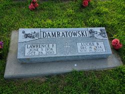
Lawrence F Damratowski
| Birth | : | 2 Jun 1936 Loup City, Sherman County, Nebraska, USA |
| Death | : | 28 Oct 2010 Columbus, Platte County, Nebraska, USA |
| Burial | : | Birtley Crematorium and Cemetery, Birtley, Metropolitan Borough of Gateshead, England |
| Coordinate | : | 54.9052590, -1.5832360 |
| Description | : | Lawrence F. Damratowski, 74, of Albion died Thursday, Oct. 28, 2010, at the Golden Living Center in Columbus. Lawrence was born June 2, 1936, at Loup City, to Felix and Elizabeth (Stenka) Damratowski. He was preceded in death by his wife, Lucille, on Nov. 16, 2004. Lawrence is survivors by: sister, Loretta Paprocki of St. Edward and a host of friends and relatives. Lawrence attended Sherman County schools District No. 38 southwest of Loup City. He attended fifth and sixth grades at parochial school in town, and completed seventh and eighth grades back in... Read More |
frequently asked questions (FAQ):
-
Where is Lawrence F Damratowski's memorial?
Lawrence F Damratowski's memorial is located at: Birtley Crematorium and Cemetery, Birtley, Metropolitan Borough of Gateshead, England.
-
When did Lawrence F Damratowski death?
Lawrence F Damratowski death on 28 Oct 2010 in Columbus, Platte County, Nebraska, USA
-
Where are the coordinates of the Lawrence F Damratowski's memorial?
Latitude: 54.9052590
Longitude: -1.5832360
Family Members:
Parent
Spouse
Siblings
Flowers:
Nearby Cemetories:
1. Birtley Crematorium and Cemetery
Birtley, Metropolitan Borough of Gateshead, England
Coordinate: 54.9052590, -1.5832360
2. St Joseph Roman Catholic Churchyard
Birtley, Metropolitan Borough of Gateshead, England
Coordinate: 54.8981200, -1.5773600
3. St John the Evangelist Churchyard
Birtley, Metropolitan Borough of Gateshead, England
Coordinate: 54.8943500, -1.5742700
4. St Andrews Churchyard
Lamesley, Metropolitan Borough of Gateshead, England
Coordinate: 54.9154000, -1.6076010
5. St Oswald’s Roman Catholic Cemetery
Wrekenton, Metropolitan Borough of Gateshead, England
Coordinate: 54.9278600, -1.5732900
6. Holy Trinity Churchyard
Usworth, Metropolitan Borough of Sunderland, England
Coordinate: 54.9205210, -1.5385030
7. St. John's Churchyard Gateshead Fell
Sheriff Hill, Metropolitan Borough of Gateshead, England
Coordinate: 54.9384680, -1.5882350
8. Our Blessed Lady Immaculate RC Churchyard
Washington, Metropolitan Borough of Sunderland, England
Coordinate: 54.9035800, -1.5212300
9. St. Alban's Churchyard
Windy Nook, Metropolitan Borough of Gateshead, England
Coordinate: 54.9426030, -1.5765070
10. Saltwell Crematorium
Gateshead, Metropolitan Borough of Gateshead, England
Coordinate: 54.9406000, -1.6066100
11. Saltwell Cemetery
Gateshead, Metropolitan Borough of Gateshead, England
Coordinate: 54.9407400, -1.6068600
12. Holy Trinity Churchyard
Washington, Metropolitan Borough of Sunderland, England
Coordinate: 54.9031000, -1.5167800
13. Washington Cemetery
Washington, Metropolitan Borough of Sunderland, England
Coordinate: 54.9029540, -1.5149770
14. Holy Trinity Churchyard and Cemetery
Pelton, Durham Unitary Authority, England
Coordinate: 54.8720010, -1.6197170
15. St. George's Churchyard
Fatfield, Metropolitan Borough of Sunderland, England
Coordinate: 54.8803030, -1.5302700
16. Heworth Cemetery
Heworth, Metropolitan Borough of Gateshead, England
Coordinate: 54.9501570, -1.5510870
17. St. Mary's Churchyard
Heworth, Metropolitan Borough of Gateshead, England
Coordinate: 54.9509290, -1.5539500
18. St Mary and St Cuthbert Churchyard
Chester-Le-Street, Durham Unitary Authority, England
Coordinate: 54.8559050, -1.5717160
19. Gateshead East Cemetery
Gateshead, Metropolitan Borough of Gateshead, England
Coordinate: 54.9560360, -1.5939800
20. Ropery Lane Cemetery
Chester-Le-Street, Durham Unitary Authority, England
Coordinate: 54.8514400, -1.5690300
21. St Josephs Roman Catholic Church
Gateshead, Metropolitan Borough of Gateshead, England
Coordinate: 54.9594469, -1.6018142
22. St Cuthbert's Church Yard
Marley Hill, Metropolitan Borough of Gateshead, England
Coordinate: 54.9174339, -1.6817654
23. St. Barnabas Churchyard
Bournmoor, Durham Unitary Authority, England
Coordinate: 54.8571260, -1.5195110
24. All Saints Churchyard
Penshaw, Metropolitan Borough of Sunderland, England
Coordinate: 54.8788450, -1.4883190

