

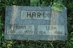
Leah Sloat/Slat Hart
| Birth | : | 1814 Pennsylvania, USA |
| Death | : | 1904 Millville, Clayton County, Iowa, USA |
| Burial | : | Friedlein Cemetery, Millville, Clayton County, USA |
| Coordinate | : | 42.7080994, -91.1108017 |
| Description | : | Source: Pennsylvania, Church and Town Records, 1708-1985 Name: John Hart Marriage Date: 21 Jul 1833 Marriage Place: Ephrata, Lancaster, Pennsylvania Spouse Name: Leah Slat Organization Name: Bethany United Church of Christ ADDITIONAL INFORMATION PROVIDED BY: [email protected] |
frequently asked questions (FAQ):
-
Where is Leah Sloat/Slat Hart's memorial?
Leah Sloat/Slat Hart's memorial is located at: Friedlein Cemetery, Millville, Clayton County, USA.
-
When did Leah Sloat/Slat Hart death?
Leah Sloat/Slat Hart death on 1904 in Millville, Clayton County, Iowa, USA
-
Where are the coordinates of the Leah Sloat/Slat Hart's memorial?
Latitude: 42.7080994
Longitude: -91.1108017
Family Members:
Spouse
Children


Flowers:


Nearby Cemetories:
1. Friedlein Cemetery
Millville, Clayton County, USA
Coordinate: 42.7080994, -91.1108017
2. Bierer Cemetery
Millville, Clayton County, USA
Coordinate: 42.7230500, -91.0925166
3. Redman Cemetery
Millville, Clayton County, USA
Coordinate: 42.7166755, -91.0852901
4. Graham Cemetery
Millville, Clayton County, USA
Coordinate: 42.6833172, -91.1195685
5. Bolsinger Cemetery
Mallory Township, Clayton County, USA
Coordinate: 42.6776340, -91.1424090
6. Saint Johns Cemetery
Jefferson Township, Clayton County, USA
Coordinate: 42.7497000, -91.1133000
7. Bethel Cemetery
Osterdock, Clayton County, USA
Coordinate: 42.7041702, -91.1688919
8. Goshen Cemetery
Millville, Clayton County, USA
Coordinate: 42.6905594, -91.0544434
9. Noggle Cemetery
Clayton County, USA
Coordinate: 42.6666580, -91.1654100
10. Guttenberg Cemetery
Guttenberg, Clayton County, USA
Coordinate: 42.7691994, -91.1035995
11. Lewis Cemetery
Osterdock, Clayton County, USA
Coordinate: 42.7416000, -91.1834000
12. Saint Marys Cemetery
Guttenberg, Clayton County, USA
Coordinate: 42.7691994, -91.1352997
13. Myer Cemetery
Luxemburg, Dubuque County, USA
Coordinate: 42.6455760, -91.0762740
14. Mount Olivet Cemetery
Guttenberg, Clayton County, USA
Coordinate: 42.7764840, -91.1083560
15. Storck Cemetery
Guttenberg, Clayton County, USA
Coordinate: 42.7694335, -91.1834638
16. Saint Paula Cemetery
Osterdock, Clayton County, USA
Coordinate: 42.7635994, -91.1992035
17. Brown Cemetery
Mallory Township, Clayton County, USA
Coordinate: 42.6530991, -91.2005997
18. Oak Hill Cemetery
Colesburg, Delaware County, USA
Coordinate: 42.6391983, -91.1924973
19. Hansel Cemetery
Mallory Township, Clayton County, USA
Coordinate: 42.7066994, -91.2433014
20. Saint Charles Catholic Church Cemetery
Cassville, Grant County, USA
Coordinate: 42.7144000, -90.9764000
21. Charlotte Cemetery
Glen Haven, Grant County, USA
Coordinate: 42.7933006, -91.0381012
22. Saint Patricks Cemetery
Colesburg, Delaware County, USA
Coordinate: 42.6241989, -91.1928024
23. Old Saint Marys Cemetery
Glen Haven, Grant County, USA
Coordinate: 42.8078100, -91.0675330
24. Cassville Cemetery
Cassville, Grant County, USA
Coordinate: 42.7324982, -90.9713974