

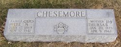
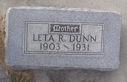
Lee Nathan Chesemore
| Birth | : | 17 Jul 1869 Rockbridge, Richland County, Wisconsin, USA |
| Death | : | 12 Nov 1941 Overton, Dawson County, Nebraska, USA |
| Burial | : | Woodlawn Memorial Park, Easton, Talbot County, USA |
| Coordinate | : | 38.8610992, -76.0597000 |
| Inscription | : | Chesemore |
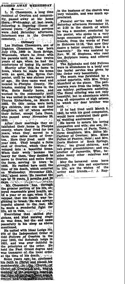
| Description | : | Source: The Elm Creek Beacon (Elm Creek, Nebraska) 28 Nov 1941 pg. 3 and extended information found in a clipping from "Harold, Overton, Nebraska". PASSED AWAY WEDNESDAY L.N. Chesemore, a long time resident of Overton and community, passed away at this home there – Wednesday of last week, following a lingering illness of several years. Funeral services were held Saturday afternoon. Interment was in the Overton cemetery. OBITUARY Lee Nathan Chesemore, son of Dighton Chesemore, was born July 17, 1869 in Rock Bridge, Wisconsin, where he lived with his parents until he... Read More |
frequently asked questions (FAQ):
-
Where is Lee Nathan Chesemore's memorial?
Lee Nathan Chesemore's memorial is located at: Woodlawn Memorial Park, Easton, Talbot County, USA.
-
When did Lee Nathan Chesemore death?
Lee Nathan Chesemore death on 12 Nov 1941 in Overton, Dawson County, Nebraska, USA
-
Where are the coordinates of the Lee Nathan Chesemore's memorial?
Latitude: 38.8610992
Longitude: -76.0597000
Family Members:
Parent
Spouse
Siblings
Children
Flowers:


Nearby Cemetories:
1. Woodlawn Memorial Park
Easton, Talbot County, USA
Coordinate: 38.8610992, -76.0597000
2. All Saints Cemetery
Easton, Talbot County, USA
Coordinate: 38.8464012, -76.0817032
3. Hopkins-Stafford Family Cemetery
Skipton, Talbot County, USA
Coordinate: 38.8896488, -76.0609487
4. Saint Pauls Cemetery
Cordova, Talbot County, USA
Coordinate: 38.8802986, -76.0149994
5. Newton Road Cemetery
Cordova, Talbot County, USA
Coordinate: 38.9020538, -76.0510101
6. Chapel Cemetery
Easton, Talbot County, USA
Coordinate: 38.8171997, -76.0211029
7. Saint Joseph's Cemetery
Cordova, Talbot County, USA
Coordinate: 38.9099998, -76.0132980
8. Ashby-Goldsborough Family Cemetery
Easton, Talbot County, USA
Coordinate: 38.8251600, -76.1239840
9. Fairview Church of the Brethren Cemetery
Talbot County, USA
Coordinate: 38.8568993, -75.9757996
10. Lombardy Farm Cemetery
Unionville, Talbot County, USA
Coordinate: 38.8158530, -76.1259852
11. Old Wye Episcopal Church Cemetery
Wye Mills, Talbot County, USA
Coordinate: 38.9366989, -76.0800018
12. Clayton Cemetery
Wye Mills, Talbot County, USA
Coordinate: 38.9297780, -76.1058167
13. Maryland State Police Canine Cemetery Barrack I
Easton, Talbot County, USA
Coordinate: 38.7843938, -76.0753632
14. Saint Stephens Church Cemetery
Easton, Talbot County, USA
Coordinate: 38.8091020, -76.1397660
15. Spring Hill Cemetery
Easton, Talbot County, USA
Coordinate: 38.7775002, -76.0727997
16. Wye House Cemetery
Easton, Talbot County, USA
Coordinate: 38.8545500, -76.1678100
17. Richards Memorial Park
Easton, Talbot County, USA
Coordinate: 38.7761002, -76.0821991
18. Doverbrook Cemetery
Easton, Talbot County, USA
Coordinate: 38.7733002, -76.0643997
19. Tuckahoe Friends Meeting House Burying Ground
Talbot County, USA
Coordinate: 38.8253460, -75.9531270
20. DeShields Cemetery
Talbot County, USA
Coordinate: 38.8278008, -76.1678009
21. Kings Creek Cemetery
Talbot County, USA
Coordinate: 38.8167000, -75.9527969
22. Third Haven Meeting Burial Ground
Easton, Talbot County, USA
Coordinate: 38.7672005, -76.0764008
23. Clover Fields Farm Cemetery
Queenstown, Queen Anne's County, USA
Coordinate: 38.9551960, -76.0896240
24. Wye of Carmichael Cemetery
Queen Anne's County, USA
Coordinate: 38.9411011, -76.1335983