
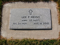

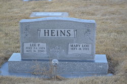
Lee Paul Heins
| Birth | : | 24 Jul 1929 Loup City, Sherman County, Nebraska, USA |
| Death | : | 16 Aug 2010 Brownson, Cheyenne County, Nebraska, USA |
| Burial | : | Mission Garden of Memories Cemetery, Clovis, Curry County, USA |
| Coordinate | : | 34.4049263, -103.2436752 |
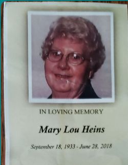
| Description | : | Lee Paul Heins, 81, of Brownson died Monday, Aug. 16, 2010, at Memorial Health Center in Sidney. Lee was born July 24, 1929, in Loup City to Fred and Bertha (Holzerland) Heins. Survivors are: his wife, Mary Lou Heins of Brownson; stepsons and stepdaughter-in-law, Bruce Woodward of Maryville, Mo., and Craig and Janet Woodward of Shenendoah, Iowa; grandsons, Ryan, Kevin Travis, and Nathan Woodward, granddaughter, Michelle Woodward; six great-grand children; brothers-in-law, Jim Smith and wife, Annette of North Platte and LeRoy Chaon of Ontario, Canada; sister-in-law, Alice Chaon of Sidney; and many nieces, nephews and cousins. Lee served over 20... Read More |
frequently asked questions (FAQ):
-
Where is Lee Paul Heins's memorial?
Lee Paul Heins's memorial is located at: Mission Garden of Memories Cemetery, Clovis, Curry County, USA.
-
When did Lee Paul Heins death?
Lee Paul Heins death on 16 Aug 2010 in Brownson, Cheyenne County, Nebraska, USA
-
Where are the coordinates of the Lee Paul Heins's memorial?
Latitude: 34.4049263
Longitude: -103.2436752
Family Members:
Parent
Spouse
Siblings

Flowers:


Nearby Cemetories:
1. Mission Garden of Memories Cemetery
Clovis, Curry County, USA
Coordinate: 34.4049263, -103.2436752
2. Lawn Haven Memorial Gardens Cemetery
Clovis, Curry County, USA
Coordinate: 34.4333000, -103.1856003
3. Black Tower Cemetery
Curry County, USA
Coordinate: 34.4087510, -103.3365440
4. Reid Cemetery
Ranchvale, Curry County, USA
Coordinate: 34.4937440, -103.3188840
5. Texico Cemetery
Texico, Curry County, USA
Coordinate: 34.3758011, -103.0849991
6. Pleasant Hill Cemetery
Pleasant Hill, Curry County, USA
Coordinate: 34.5349998, -103.0733032
7. Bobo Qualls Cemetery
Ranchvale, Curry County, USA
Coordinate: 34.5211670, -103.4501290
8. Portales Cemetery
Portales, Roosevelt County, USA
Coordinate: 34.1860500, -103.3199200
9. West Camp Cemetery
Bailey County, USA
Coordinate: 34.2811012, -102.9757996
10. Rest Lawn Memorial Cemetery
Portales, Roosevelt County, USA
Coordinate: 34.1342010, -103.3347015
11. Bethel Cemetery
Roosevelt County, USA
Coordinate: 34.2146988, -103.4961014
12. Eiland Cemetery
Roosevelt County, USA
Coordinate: 34.1169014, -103.1949997
13. Arch Cemetery
Roosevelt County, USA
Coordinate: 34.1133003, -103.1418991
14. Memorial Cemetery
Melrose, Curry County, USA
Coordinate: 34.4307251, -103.6171112
15. Roach Cemetery
Curry County, USA
Coordinate: 34.6618996, -103.4828033
16. North Cemetery
Melrose, Curry County, USA
Coordinate: 34.4496994, -103.6410980
17. Floyd Cemetery
Floyd, Roosevelt County, USA
Coordinate: 34.2141991, -103.5800018
18. Field Cemetery
Field, Curry County, USA
Coordinate: 34.6618996, -103.5738983
19. Hollene Cemetery
Hollene, Curry County, USA
Coordinate: 34.7774950, -103.0994210
20. Muleshoe Memorial Park Cemetery
Muleshoe, Bailey County, USA
Coordinate: 34.2634100, -102.7851800
21. Bailey County Cemetery
Muleshoe, Bailey County, USA
Coordinate: 34.2859600, -102.7661950
22. Stockton Cemetery
Forrest, Quay County, USA
Coordinate: 34.7649000, -103.4962000
23. Upton Cemetery
Upton, Roosevelt County, USA
Coordinate: 34.1553001, -103.6524963
24. Grady City Cemetery
Grady, Curry County, USA
Coordinate: 34.8260000, -103.3105000