
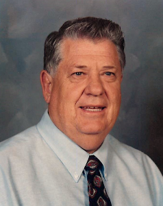
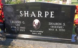

Leland “Lee” Sharpe
| Birth | : | 1 Mar 1940 Clyde, Cloud County, Kansas, USA |
| Death | : | 9 Nov 2013 Manhattan, Riley County, Kansas, USA |
| Burial | : | Mount Hope Cemetery, Clyde, Cloud County, USA |
| Coordinate | : | 39.5969009, -97.4116974 |
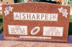
| Description | : | Leland Sharpe, 73, passed away in the early hours of Saturday, November 9, 2013 at the Bramlage Transition House in Manhattan, Kansas from complications of a stroke he suffered on June 24, 2013. Lee was born March 1, 1940 in Clyde, Kansas to parents George and Lena (Goering) Sharpe. Leland was a life-long member of the First United Methodist Church of Clyde, Kansas. He graduated from Clyde High School in 1958. He was active in all sports and music as well. Lee attended Kansas Wesleyan College for one year and played varsity basketball. He transferred to Kansas State College in the... Read More |
frequently asked questions (FAQ):
-
Where is Leland “Lee” Sharpe's memorial?
Leland “Lee” Sharpe's memorial is located at: Mount Hope Cemetery, Clyde, Cloud County, USA.
-
When did Leland “Lee” Sharpe death?
Leland “Lee” Sharpe death on 9 Nov 2013 in Manhattan, Riley County, Kansas, USA
-
Where are the coordinates of the Leland “Lee” Sharpe's memorial?
Latitude: 39.5969009
Longitude: -97.4116974
Family Members:
Parent

Siblings

Flowers:


Nearby Cemetories:
1. Mount Calvary Cemetery
Clyde, Cloud County, USA
Coordinate: 39.5917015, -97.4143982
2. Cedar Grove Cemetery
Clyde, Cloud County, USA
Coordinate: 39.5494003, -97.4056015
3. Pleasant View Cemetery
Ames, Cloud County, USA
Coordinate: 39.5346985, -97.4431000
4. Walnut Grove Cemetery
Cloud County, USA
Coordinate: 39.5699997, -97.4993973
5. Agenda Cemetery
Agenda, Republic County, USA
Coordinate: 39.6761017, -97.4336014
6. Saint Joseph Cemetery
Saint Joseph, Cloud County, USA
Coordinate: 39.5074941, -97.4022328
7. Beck Family Cemetery
Agenda, Republic County, USA
Coordinate: 39.6818000, -97.4863000
8. Green Mound Cemetery
Rice, Cloud County, USA
Coordinate: 39.5248450, -97.5081630
9. Hollis Cemetery
Cloud County, USA
Coordinate: 39.6383018, -97.5361023
10. Rice Cemetery
Rice, Cloud County, USA
Coordinate: 39.5614014, -97.5552979
11. Nelson Cemetery
Rice, Cloud County, USA
Coordinate: 39.5257988, -97.5410995
12. Riverdale Cemetery
Clay County, USA
Coordinate: 39.5106010, -97.2930984
13. Willoughby Cemetery
Agenda, Republic County, USA
Coordinate: 39.7402992, -97.4244003
14. Union Cemetery
Wayne, Republic County, USA
Coordinate: 39.6977997, -97.5457993
15. Saint Peters Cemetery
Aurora, Cloud County, USA
Coordinate: 39.4763985, -97.5180969
16. Princeville Cemetery
Aurora, Cloud County, USA
Coordinate: 39.4672012, -97.5010986
17. Iwacura Cemetery
Morganville, Clay County, USA
Coordinate: 39.4550000, -97.3510000
18. Gotland Cemetery
Sibley Township, Cloud County, USA
Coordinate: 39.6091995, -97.6125031
19. French Presbyterian Church Cemetery
Cloud County, USA
Coordinate: 39.4395200, -97.4148290
20. Sherman Cemetery
Morganville, Clay County, USA
Coordinate: 39.5316300, -97.2243700
21. Zion Cemetery
Agenda, Republic County, USA
Coordinate: 39.6749992, -97.5939026
22. Rose Hill Cemetery
Wayne, Republic County, USA
Coordinate: 39.7111015, -97.5661011
23. Minersville Cemetery
Talmo, Republic County, USA
Coordinate: 39.6568330, -97.6229250
24. Bloom Cemetery
Morganville, Clay County, USA
Coordinate: 39.4519005, -97.2778015