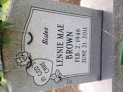
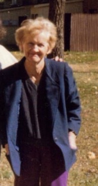
Lennie Mae Brown
| Birth | : | 2 Feb 1946 |
| Death | : | 21 Jun 2011 North Carolina, USA |
| Burial | : | Mountain Park Cemetery, Mountain Park, Surry County, USA |
| Coordinate | : | 36.3770828, -80.8549194 |
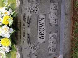
| Description | : | Ms. Lennie Mae Brown, 65, of Dobson passed away peacefully on Tuesday June 21, 2011 at Village Care of King surrounded by her loving family. She was born in Surry County on February 2, 1946 to the late William Franklin and Ruth Norman Brown. She leaves to cherish her memory her devoted sisters, Ellen Shelton of Pilot Mountain and Mary Ann and husband Bobby Bowman of Dobson; two brothers, Robert Wayne Brown of Thomasville and David and wife Janice Brown of Dobson; several nieces and nephews. In addition to her parents, Ms. Brown was preceded in death by a son... Read More |
frequently asked questions (FAQ):
-
Where is Lennie Mae Brown's memorial?
Lennie Mae Brown's memorial is located at: Mountain Park Cemetery, Mountain Park, Surry County, USA.
-
When did Lennie Mae Brown death?
Lennie Mae Brown death on 21 Jun 2011 in North Carolina, USA
-
Where are the coordinates of the Lennie Mae Brown's memorial?
Latitude: 36.3770828
Longitude: -80.8549194
Family Members:
Flowers:
Nearby Cemetories:
1. Mountain Park Cemetery
Mountain Park, Surry County, USA
Coordinate: 36.3770828, -80.8549194
2. Charity Hill Baptist Church Cemetery
Mountain Park, Surry County, USA
Coordinate: 36.3858070, -80.8671951
3. Smith-Jennings Family Cemetery
Elkin Township, Surry County, USA
Coordinate: 36.3736616, -80.8377105
4. Kennedy Cemetery
Mountain Park, Surry County, USA
Coordinate: 36.3668740, -80.8746310
5. Cockerham Graveyard
Mountain Park, Surry County, USA
Coordinate: 36.3518100, -80.8540160
6. Samuel Isaacks Cemetery
Thurmond, Surry County, USA
Coordinate: 36.3978610, -80.8729170
7. Lineberry Family Cemetery
Dobson, Surry County, USA
Coordinate: 36.3961300, -80.8276300
8. Swift Family Cemetery
Mountain Park, Surry County, USA
Coordinate: 36.3474731, -80.8469162
9. Mann Family Cemetery
Elkin, Surry County, USA
Coordinate: 36.3656990, -80.8189490
10. Golden Family Cemetery
State Road, Surry County, USA
Coordinate: 36.3439700, -80.8567300
11. Laster Wall Cemetery
Elkin, Surry County, USA
Coordinate: 36.3557222, -80.8224722
12. Union Hill Baptist Church Cemetery
Union Hill, Surry County, USA
Coordinate: 36.4012500, -80.8848610
13. Zephyr Cemetery
Elkin, Surry County, USA
Coordinate: 36.3669170, -80.8140280
14. Harris Family Cemetery
Thurmond, Surry County, USA
Coordinate: 36.3858870, -80.8968290
15. Rocky Ford Baptist Church Cemetery
Mountain Park, Surry County, USA
Coordinate: 36.4160576, -80.8523865
16. State Road Primitive Baptist Church Cemetery
State Road, Surry County, USA
Coordinate: 36.3520279, -80.8977814
17. Moody Family Cemetery
State Road, Surry County, USA
Coordinate: 36.3382510, -80.8846200
18. Central Full Gospel Church Cemetery
State Road, Surry County, USA
Coordinate: 36.3346252, -80.8777466
19. Mount Pleasant Baptist Church Cemetery
State Road, Surry County, USA
Coordinate: 36.3289030, -80.8670950
20. White Rock Methodist Cemetery
Thurmond, Surry County, USA
Coordinate: 36.3875008, -80.9192200
21. Salem Fork Christian Church Cemetery
Salemfork, Surry County, USA
Coordinate: 36.3950386, -80.7884827
22. Dayspring Baptist Chapel Cemetery
Salemfork, Surry County, USA
Coordinate: 36.3996270, -80.7895910
23. Jesse Venable Family Cemetery
Surry County, USA
Coordinate: 36.4050000, -80.7925000
24. Pleasant Union Baptist Church Cemetery
Salemfork, Surry County, USA
Coordinate: 36.4208060, -80.8063610


