
Leonard B. Arms
| Birth | : | 1820 Adams, Berkshire County, Massachusetts, USA |
| Death | : | 20 Apr 1860 Topeka, Shawnee County, Kansas, USA |
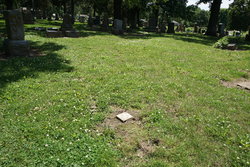
| Burial | : | Oak Hill Cemetery, Lawrence, Douglas County, USA |
| Coordinate | : | 38.9589005, -95.2118988 |
| Inscription | : | The original headstone no longer exists. The lot contains several graves, but all of its headstones have deteriorated. |
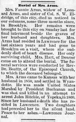
| Description | : | Leonard B. Arms was a deputy US Marshal. On 20 April 1860, he was shot and killed by John Ritchie, who was resisting arrest. An annotated version, of an informed account of the incident and its aftermath, follows: Kansas Press (Council Grove, Kansas Territory), 30 April 1860, page 2. Samuel N. Wood, editor. Homicide at Topeka Our exchanges, especially from Topeka, are filled with accounts of the late [viz., 20 April 1860] homicide [of Deputy US Marshal Leonard B. Arms] at that place. We [editor Samuel N. Wood Samuel N. Wood, who... Read More |
frequently asked questions (FAQ):
-
Where is Leonard B. Arms's memorial?
Leonard B. Arms's memorial is located at: Oak Hill Cemetery, Lawrence, Douglas County, USA.
-
When did Leonard B. Arms death?
Leonard B. Arms death on 20 Apr 1860 in Topeka, Shawnee County, Kansas, USA
-
Where are the coordinates of the Leonard B. Arms's memorial?
Latitude: 38.9589005
Longitude: -95.2118988
Family Members:
Parent
Spouse
Siblings
Children

Flowers:


Nearby Cemetories:
1. Oak Hill Cemetery
Lawrence, Douglas County, USA
Coordinate: 38.9589005, -95.2118988
2. Mount Calvary Catholic Cemetery
Lawrence, Douglas County, USA
Coordinate: 38.9580002, -95.2139969
3. Memorial Park Cemetery
Lawrence, Douglas County, USA
Coordinate: 38.9552994, -95.2153015
4. Trinity Episcopal Church Columbarium
Lawrence, Douglas County, USA
Coordinate: 38.9653893, -95.2373886
5. Saint Johns Catholic Cemetery
Douglas County, USA
Coordinate: 38.9437900, -95.1919600
6. Dyche Hall Natural History Museum
Lawrence, Douglas County, USA
Coordinate: 38.9584800, -95.2434800
7. Franklin Cemetery
Douglas County, USA
Coordinate: 38.9437523, -95.1869431
8. Haskell Cemetery
Lawrence, Douglas County, USA
Coordinate: 38.9353790, -95.2284241
9. Pioneer Cemetery
Lawrence, Douglas County, USA
Coordinate: 38.9528008, -95.2611008
10. First Presbyterian Church Memorial Garden
Lawrence, Douglas County, USA
Coordinate: 38.9414900, -95.2641600
11. Maple Grove Cemetery
Lawrence, Douglas County, USA
Coordinate: 39.0018997, -95.2316971
12. County Poor Farm Cemetery
Douglas County, USA
Coordinate: 38.9119400, -95.2214600
13. Adams Cemetery
Douglas County, USA
Coordinate: 38.9955400, -95.2509100
14. Kennedy Cemetery
Douglas County, USA
Coordinate: 38.9112900, -95.2269200
15. Davis Cemetery
Lawrence, Douglas County, USA
Coordinate: 38.9722500, -95.2831100
16. Blue Mound Cemetery
Lawrence, Douglas County, USA
Coordinate: 38.9046600, -95.1865400
17. Marshall Cemetery
Douglas County, USA
Coordinate: 38.9040800, -95.2446700
18. Dutton Cemetery
Douglas County, USA
Coordinate: 38.8989800, -95.2790600
19. Luckan Family Cemetery
Fall Leaf, Leavenworth County, USA
Coordinate: 38.9808500, -95.1128000
20. Cemetery Beni Israel
Eudora, Douglas County, USA
Coordinate: 38.9280128, -95.1122208
21. Southwest City Cemetery
Eudora, Douglas County, USA
Coordinate: 38.9334800, -95.1070300
22. Lyon Family Cemetery
Lawrence, Douglas County, USA
Coordinate: 38.9877440, -95.3166530
23. Corpus Christi Catholic Church Columbarium
Lawrence, Douglas County, USA
Coordinate: 38.9572250, -95.3238450
24. Richland Cemetery
Lawrence, Douglas County, USA
Coordinate: 38.8768997, -95.2630997