
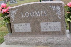
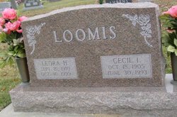
Leora Harriet Hays Loomis
| Birth | : | 21 Sep 1910 Manilla, Crawford County, Iowa, USA |
| Death | : | 16 Oct 1999 Mitchellville, Polk County, Iowa, USA |
| Burial | : | Saint Nicholas Parish Churchyard, Sabden, Ribble Valley Borough, England |
| Coordinate | : | 53.8346503, -2.3332764 |
| Plot | : | Section Pleasant Hill, Row 03, Grave 04 |
frequently asked questions (FAQ):
-
Where is Leora Harriet Hays Loomis's memorial?
Leora Harriet Hays Loomis's memorial is located at: Saint Nicholas Parish Churchyard, Sabden, Ribble Valley Borough, England.
-
When did Leora Harriet Hays Loomis death?
Leora Harriet Hays Loomis death on 16 Oct 1999 in Mitchellville, Polk County, Iowa, USA
-
Where are the coordinates of the Leora Harriet Hays Loomis's memorial?
Latitude: 53.8346503
Longitude: -2.3332764
Family Members:
Parent
Spouse
Siblings
Flowers:


Nearby Cemetories:
1. Saint Nicholas Parish Churchyard
Sabden, Ribble Valley Borough, England
Coordinate: 53.8346503, -2.3332764
2. St John Churchyard
Higham, Pendle Borough, England
Coordinate: 53.8251420, -2.2898120
3. St. John's Churchyard
Read, Ribble Valley Borough, England
Coordinate: 53.8088800, -2.3585600
4. St. Leonard's Churchyard
Padiham, Burnley Borough, England
Coordinate: 53.8022600, -2.3164300
5. Wesleyan Methodist Chapel Chapelyard
Padiham, Burnley Borough, England
Coordinate: 53.8018980, -2.3181730
6. St Leonard Churchyard Extension
Padiham, Burnley Borough, England
Coordinate: 53.7991800, -2.3222000
7. St. Anne Churchyard
Fence, Pendle Borough, England
Coordinate: 53.8304372, -2.2679552
8. St. Mary's Churchyard
Newchurch in Pendle, Pendle Borough, England
Coordinate: 53.8504181, -2.2706807
9. St. John's Cemetery
Padiham, Burnley Borough, England
Coordinate: 53.7948720, -2.3145290
10. St James Church
Altham, Hyndburn Borough, England
Coordinate: 53.7928940, -2.3465250
11. Whalley, Wiswell and Barrow Cemetery
Whalley, Ribble Valley Borough, England
Coordinate: 53.8308490, -2.4057280
12. Wheatley Lane Methodist Churchyard
Fence, Pendle Borough, England
Coordinate: 53.8341457, -2.2596202
13. All Saints Churchyard
Habergham Eaves, Burnley Borough, England
Coordinate: 53.7971060, -2.2913770
14. Saint Mary and All Saints Churchyard
Whalley, Ribble Valley Borough, England
Coordinate: 53.8211890, -2.4078080
15. St James Churchyard
Clitheroe, Ribble Valley Borough, England
Coordinate: 53.8659600, -2.3922700
16. Queen Mary's Military Hospital Cemetery
Whalley, Ribble Valley Borough, England
Coordinate: 53.8337490, -2.4127930
17. Calderstones Hospital Cemetery
Whalley, Ribble Valley Borough, England
Coordinate: 53.8338710, -2.4147160
18. Trinity Methodist Churchyard
Clitheroe, Ribble Valley Borough, England
Coordinate: 53.8709060, -2.3954550
19. St Mary Magdalene Churchyard
Clitheroe, Ribble Valley Borough, England
Coordinate: 53.8740980, -2.3903420
20. Wheatley Lane Inghamite Church Churchyard
Wheatley Lane, Pendle Borough, England
Coordinate: 53.8412800, -2.2457100
21. St Margaret Churchyard
Hapton, Burnley Borough, England
Coordinate: 53.7802400, -2.3169230
22. St. Joseph's Roman Catholic Cemetery
Clitheroe, Ribble Valley Borough, England
Coordinate: 53.8770700, -2.3960000
23. Clitheroe Cemetery
Clitheroe, Ribble Valley Borough, England
Coordinate: 53.8779250, -2.3984550
24. Twiston Quaker Burial Ground
Clitheroe, Ribble Valley Borough, England
Coordinate: 53.8854210, -2.2838840